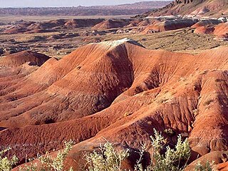
The Painted Desert is a United States desert of badlands in the Four Corners area, running from near the east end of Grand Canyon National Park and southeast into Petrified Forest National Park. It is most easily accessed from the north portion of Petrified Forest National Park. The Painted Desert is known for its brilliant and varied colors: these include the more common red rock, but also shades of lavender.
In geomorphology, a butte is an isolated hill with steep, often vertical sides and a small, relatively flat top; buttes are smaller landforms than mesas, plateaus, and tablelands. The word butte comes from the French word butte, meaning knoll ; its use is prevalent in the Western United States, including the southwest where mesa is used for the larger landform. Due to their distinctive shapes, buttes are frequently landmarks in plains and mountainous areas. To differentiate the two landforms, geographers use the rule of thumb that a mesa has a top that is wider than its height, while a butte has a top that is narrower than its height.

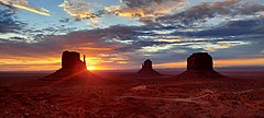
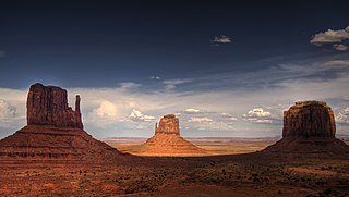
Monument Valley is a region of the Colorado Plateau characterized by a cluster of sandstone buttes, the largest reaching 1,000 ft (300 m) above the valley floor. The most famous butte formations are located in northeastern Arizona along the Utah–Arizona state line. The valley is considered sacred by the Navajo Nation, the Native American people within whose reservation it lies.

Hunts Mesa is a rock formation located in Monument Valley, south of the border between Utah and Arizona in the United States and west of the border between Arizona's Navajo County and Apache County. It is one of two popular interior destinations in the Monument Valley Navajo Tribal Park for tourists to experience panoramic views of the popular sandstone formations from a distance. The other is Mystery Valley. A Navajo guide is required to hike to either.

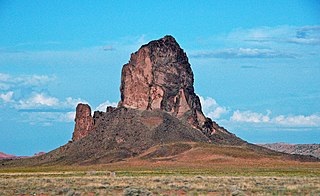
Agathla Peak or Agathlan is a peak south of Monument Valley, Arizona, which rises over 1,500 feet above the surrounding terrain. It is 7 miles (11 km) north of Kayenta and is visible from U.S. Route 163. The English designation Agathla is derived from the Navajo name aghaałą́ meaning 'much wool', apparently for the fur of antelope and deer accumulating on the rock. The mountain is considered sacred by the Navajo.

Navajo Mountain is a peak in San Juan County, Utah, with its southern flank extending into Coconino County, Arizona, in the United States. It holds an important place in the traditions of three local Native American tribes. The summit is the highest point on the Navajo Nation.

The Chuska Mountains are an elongate range on the southwest Colorado Plateau and within the Navajo Nation whose highest elevations approach 10,000 feet. The range is about 80 by 15 km. It trends north-northwest and is crossed by the state line between Arizona and New Mexico. The highlands are a dissected plateau, with an average elevation of about 2,740 m (8,990 ft), and subdued topography. The highest point is Roof Butte at 2,994 m (9,823 ft), near the northern end of the range in Arizona. Other high points include the satellite Beautiful Mountain at 2,861 m (9,386 ft) and Lukachukai Mountains at 2,885 m (9,465 ft), both also near the northern end, and Matthews Peak at 2,911 m (9,551 ft). The San Juan Basin borders the Chuskas on the east, and typical elevations in nearby parts of that basin are near 1,800 m (5,900 ft). The eastern escarpment of the mountains is marked by slumps and landslides that extend out onto the western margin of the San Juan Basin. To the north, the Chuskas are separated from the Carrizo Mountains by Red Rock Valley, which is today commonly referred to as Red Valley.
Ajo Peak is a mountain peak in southern Arizona, in the north-and-east Sonoran Desert. Two peaks are nearby, Cardigan Peak at 2,922 feet (891 m) and North Ajo Peak 2,776 feet (846 m).

Castle Dome, or Castle Dome Peak is a prominent butte and high point of the Castle Dome Mountains northeast of Yuma, Arizona, in the northwestern Sonoran Desert.

Missouri Buttes or Little Missouri Buttes are located in Crook County in northeast Wyoming on the northwest flank of the Black Hills Uplift. The buttes are 3.5 miles (5.6 km) northwest (N60°W) of Devils Tower between the Little Missouri and the Belle Fourche rivers.

Cathedral Rock is a natural sandstone butte near Sedona, Arizona, and one of the most-photographed sights in Arizona, United States. The rock formation is located in the Coconino National Forest in Yavapai County, about 1 mi (1.6 km) west of Arizona Route 179, and about 2.5 mi (4.0 km) south of the "Y" intersection of State Routes 179 and 89A in uptown Sedona. The summit elevation of Cathedral Rock is 4,967 ft (1,514 m).

Temple Butte, in the Grand Canyon, Arizona, US is a prominence below the East Rim. The butte lies on the west bank of the south-flowing Colorado River. The outfall from the Little Colorado River, draining from the Painted Desert to the east and southeast, is about two miles upstream.

Merrick Butte is a butte located in Monument Valley and is part of the Monument Valley Navajo Tribal Park, similar to its neighbors West and East Mitten Buttes just to the north. It was named after silver miner Jack Merrick, killed by Indians in 1880.

The Totem Pole is a pillar or rock spire found in Monument Valley. It is a highly eroded remnant of a butte.

The Cline Buttes are mountains with volcanic origins that form three dome-shaped peaks located in Deschutes County in central Oregon. They are some of the eastern foothills of the Cascade Range. Situated on land administered by the Bureau of Land Management, the buttes are flanked on the east and west sides by two separate sections of the Eagle Crest Resort. On the highest summit, there is a Federal Aviation Administration site with an aircraft navigation beacon. The mountains have several hiking trails as well as a number of popular mountain bike routes.

Owl Rock is a 6,547-foot elevation sandstone summit located south of Monument Valley, in northeast Arizona. It is situated 7 miles (11 km) north of Kayenta on Navajo Nation land, and can be seen from Highway 163 perched on the east edge of Tyende Mesa, where it towers 1,000 feet above the surrounding terrain. Its nearest higher neighbor is Agathla Peak, 1.4 miles (2.3 km) to the east-northeast, on the opposite side of this highway. Precipitation runoff from this feature drains into El Capitan Wash, which is part of the San Juan River drainage basin. The first ascent of Owl Rock was made in April 1966 by Fred Beckey and Harvey Carter by climbing cracks on the west face, and then bolting up a smooth south nose to the summit. They employed 20 pitons and 14 bolts on this route called Warpath. The descriptive name stems from its uncanny resemblance to an owl when viewed from the east. This feature is known as Bee 'Adizí in Navajo language meaning "spindle", and this sacred place is considered to be a spindle left behind by the Holy People. A newer name for it is Tsé Ts'óózí, meaning "Slim Rock".
Chaistla Butte is a 6,098-foot (1,859 m) elevation summit located south of Monument Valley, in Navajo County of northeast Arizona. It is situated 4.5 miles (7.2 km) northeast of the community of Kayenta, on Navajo Nation land, and can be seen from Highway 163. It is one of the eroded volcanic plugs, or diatremes, of the Navajo Volcanic Field, which is a volcanic field that includes intrusions and flows of minette and other unusual igneous rocks which formed around 30 million years ago during the Oligocene. Chaistla Butte rises 400 feet above the Little Capitan Valley, and the 1,000 by 700-foot base pokes up from the Chinle Formation. Its neighbors include Agathla Peak and Owl Rock, three miles (4.8 km) to the north-northwest. Precipitation runoff from this feature drains into the Laguña Creek drainage basin. The chaistla name, which means "beaver pocket" or "beaver corner" in the Navajo language, was officially adopted in 1915 by the U.S. Board on Geographic Names. Navajo teachings have its name meaning "to support the sky's underside", such that if this butte were to fall, the world would end. It is also known as Turkey Butte.
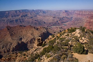
Cardenas Butte is a 6,281-foot-elevation summit located in the eastern Grand Canyon, in Coconino County of northern Arizona, Southwestern United States. Cardenas Butte is named for García López de Cárdenas, the first European to see the Grand Canyon. The butte is located on a dp orange-red ridgeline of the Supai Group, adjacent its higher elevation neighbor, Escalante Butte; both buttes are ~1.5 miles north-northwest of Navajo Point in far eastern South Rim, approaching the East Rim.
Cardenas Butte are drained on the east by Tanner Canyon, north to the Colorado River; the northwest of Cardenas Butte is drained northwest by Cardenas Creek, and north by an unnamed drainage. The Tanner Trail from Navajo Point, courses the east, upper ridges of Escalante, then Cardenas Butte, upon the Supai Group, until the trail drops down through the Redwall Limestone, at the Supai ridgeline terminus. Cardenas Butte and Escalante Butte have similar elevations, with Escalante about 300 ft higher, and westwards up the burnt-orange-red ridgeline.
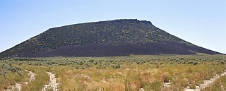
Middle Butte is a 6,391-foot elevation (1,948 m) summit located in Bingham County, Idaho, United States.