Westby, Montana

Last updated

Westby, Montana
Westby StateLine.jpg
Montana State Sign in Westby
Sheridan County Montana Incorporated and Unincorporated areas Westby Highlighted.svg
Location of Westby, Montana
Usa edcp location map.svg
Red pog.svg
Westby, Montana
Location in the United States
Coordinates: 48°52′11″N104°3′7″W / 48.86972°N 104.05194°W / 48.86972; -104.05194
Country United States
State Montana
County Sheridan
Area
[1]
  Total0.57 sq mi (1.48 km2)
  Land0.56 sq mi (1.46 km2)
  Water0.01 sq mi (0.02 km2)
Elevation
2,103 ft (641 m)
Population
 (2020)
  Total167
  Density297.15/sq mi (114.76/km2)
Time zone UTC-7 (Mountain (MST))
  Summer (DST) UTC-6 (MDT)
ZIP code
59275
Area code 406
FIPS code 30-78925
GNIS feature ID0778319

Westby is a town in Sheridan County, Montana, United States. The population was 167 at the 2020 census. [2]

Contents

History

Westby was founded in 1910 as a town in what was then Williams County, North Dakota (now in Divide County). Danish settlers came up with the name by combining the word west, which noted the town's location in extreme western North Dakota, with the word by, Danish for town. The town remained in North Dakota until 1914, when it was moved slightly across the border so as to be next to a newly built branch line of the Soo Line Railroad and in a state that permitted the sale of alcohol. [3] [4]

Geography

Westby is located at 48°52′11″N104°3′7″W / 48.86972°N 104.05194°W / 48.86972; -104.05194 (48.869847, -104.051950). [5]

According to the United States Census Bureau, the town has a total area of 0.54 square miles (1.40 km2), all land. [6]

Westby is located on the state border with North Dakota, and near the international boundary with Saskatchewan. Montana Highway 5 passes through the town.

Climate

According to the Köppen Climate Classification system, Westby has a humid continental climate, abbreviated "DFb" on climate maps. [7]

Climate data for Westby, Montana (1991–2020 normals, extremes 1937–present)
MonthJanFebMarAprMayJunJulAugSepOctNovDecYear
Record high °F (°C)55
(13)
66
(19)
77
(25)
91
(33)
102
(39)
103
(39)
112
(44)
108
(42)
103
(39)
92
(33)
73
(23)
61
(16)
112
(44)
Mean daily maximum °F (°C)19.5
(−6.9)
23.5
(−4.7)
35.7
(2.1)
52.6
(11.4)
65.3
(18.5)
73.1
(22.8)
79.9
(26.6)
80.0
(26.7)
69.6
(20.9)
53.5
(11.9)
36.1
(2.3)
23.7
(−4.6)
51.0
(10.6)
Daily mean °F (°C)8.7
(−12.9)
12.8
(−10.7)
25.0
(−3.9)
39.9
(4.4)
52.4
(11.3)
61.5
(16.4)
67.3
(19.6)
65.9
(18.8)
55.4
(13.0)
41.0
(5.0)
25.4
(−3.7)
13.7
(−10.2)
39.1
(3.9)
Mean daily minimum °F (°C)−2.2
(−19.0)
2.1
(−16.6)
14.2
(−9.9)
27.3
(−2.6)
39.5
(4.2)
49.9
(9.9)
54.6
(12.6)
51.8
(11.0)
41.1
(5.1)
28.6
(−1.9)
14.6
(−9.7)
3.8
(−15.7)
27.1
(−2.7)
Record low °F (°C)−45
(−43)
−42
(−41)
−33
(−36)
−18
(−28)
10
(−12)
28
(−2)
35
(2)
29
(−2)
15
(−9)
−6
(−21)
−26
(−32)
−42
(−41)
−45
(−43)
Average precipitation inches (mm)0.37
(9.4)
0.34
(8.6)
0.55
(14)
0.98
(25)
2.17
(55)
3.14
(80)
2.49
(63)
1.64
(42)
1.26
(32)
0.97
(25)
0.52
(13)
0.48
(12)
14.91
(379)
Source: NOAA [8]

Demographics

Historical population
CensusPop.Note
1920 253
1930 28713.4%
1940 36928.6%
1950 3967.3%
1960 309−22.0%
1970 287−7.1%
1980 2911.4%
1990 253−13.1%
2000 172−32.0%
2010 168−2.3%
2020 167−0.6%
U.S. Decennial Census [9] [2]

2010 census

As of the census [10] of 2010, there were 168 people, 82 households, and 49 families residing in the town. The population density was 311.1 inhabitants per square mile (120.1/km2). There were 114 housing units at an average density of 211.1 per square mile (81.5/km2). The racial makeup of the town was 95.8% White, 2.4% Native American, and 1.8% from two or more races. Hispanic or Latino of any race were 1.8% of the population.

There were 82 households, of which 19.5% had children under the age of 18 living with them, 53.7% were married couples living together, 3.7% had a female householder with no husband present, 2.4% had a male householder with no wife present, and 40.2% were non-families. 36.6% of all households were made up of individuals, and 12.2% had someone living alone who was 65 years of age or older. The average household size was 2.05 and the average family size was 2.67.

The median age in the town was 48.3 years. 19% of residents were under the age of 18; 4.3% were between the ages of 18 and 24; 19.1% were from 25 to 44; 35.1% were from 45 to 64; and 22.6% were 65 years of age or older. The gender makeup of the town was 52.4% male and 47.6% female.

2000 census

As of the census [11] of 2000, there were 172 people, 88 households, and 52 families residing in the town. The population density was 317.2 inhabitants per square mile (122.5/km2). There were 121 housing units at an average density of 223.1 per square mile (86.1/km2). The racial makeup of the town was 98.26% White, 1.16% Native American, and 0.58% from two or more races. Hispanic or Latino of any race were 1.74% of the population.

There were 88 households, out of which 14.8% had children under the age of 18 living with them, 51.1% were married couples living together, 5.7% had a female householder with no husband present, and 39.8% were non-families. 35.2% of all households were made up of individuals, and 23.9% had someone living alone who was 65 years of age or older. The average household size was 1.95 and the average family size was 2.47.

In the town, the population was spread out, with 15.1% under the age of 18, 2.9% from 18 to 24, 22.7% from 25 to 44, 34.3% from 45 to 64, and 25.0% who were 65 years of age or older. The median age was 50 years. For every 100 females there were 109.8 males. For every 100 females age 18 and over, there were 105.6 males.

The median income for a household in the town was $32,875, and the median income for a family was $44,583. Males had a median income of $35,625 versus $18,125 for females. The per capita income for the town was $19,438. About 4.7% of families and 9.4% of the population were below the poverty line, including none of those under the age of eighteen and 20.0% of those 65 or over.

Education

Westby School District educates students from kindergarten through 12th grade. [12] Westby High School's team name is Thunder. [13]

See also

Related Research Articles

<span class="mw-page-title-main">Divide County, North Dakota</span> County in North Dakota, United States

Divide County is a county in the U.S. state of North Dakota. As of the 2020 census, the population was 2,195. Its county seat is Crosby.

<span class="mw-page-title-main">Sheridan County, Montana</span> County in Montana, United States

Sheridan County is a county in the U.S. state of Montana. As of the 2020 census, the population was 3,539. Its county seat is Plentywood. Its northern boundary is the Canada–United States border south of Saskatchewan.

<span class="mw-page-title-main">Ismay, Montana</span> Town in Montana, United States

Ismay is a town in Custer County, Montana, United States. There is a post office at Ismay, and a church, and no other businesses or services. The population was 17 at the 2020 census. The town is the least-populous incorporated municipality in the state of Montana.

<span class="mw-page-title-main">Fairview, Montana</span> Town in Montana, United States

Fairview is a town in Richland County, Montana, United States. The population was 896 at the 2020 census. The town is directly on the North Dakota border. Fairview incorporated in 1913.

<span class="mw-page-title-main">Wibaux, Montana</span> Town in Montana, United States

Wibaux is a town in and the county seat of Wibaux County, Montana, United States. It is the only incorporated town in Wibaux County. The population was 462 at the 2020 census.

<span class="mw-page-title-main">Ellendale, North Dakota</span> City in North Dakota, United States

Ellendale is a city in Dickey County, North Dakota, United States. It is the capital city of Dickey County. The population was 1,125 at the 2020 census. Ellendale was founded in 1882. Ellendale is the home of Trinity Bible College, located on the former campus of the North Dakota State Normal and Industrial School and the Ellendale Opera House currently under renovation.

<span class="mw-page-title-main">Tabor, South Dakota</span> Town in South Dakota, United States

Tabor is a town in Bon Homme County, South Dakota, United States. The population was 407 at the 2020 census.

<span class="mw-page-title-main">Tyndall, South Dakota</span> City in South Dakota, United States

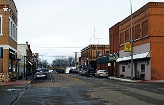
Tyndall is a city in and the county seat of Bon Homme County, South Dakota, United States. The population was 1,057 at the 2020 census.

<span class="mw-page-title-main">Westport, South Dakota</span> Town in South Dakota, United States

Westport is a town in western Brown County, South Dakota, United States. The population was 88 at the 2020 census.

<span class="mw-page-title-main">Bradley, South Dakota</span> Town in South Dakota, United States

Bradley is a town in Clark County, South Dakota, United States. The population was 65 at the 2020 census.

<span class="mw-page-title-main">Brandt, South Dakota</span> Town in South Dakota, United States

Brandt is a town in Deuel County, South Dakota, United States. The population was 114 at the 2020 census.

<span class="mw-page-title-main">Nunda, South Dakota</span> Town in South Dakota, United States

Nunda is a village in Lake County, South Dakota, United States. The population was 46 at the 2020 census. Located there are a post office, grainery, bar and grill, and an American Legion post.

<span class="mw-page-title-main">Eden, South Dakota</span> Town in South Dakota, United States

Eden is a town in Marshall County, South Dakota, United States. The population was 94 at the 2020 census.

<span class="mw-page-title-main">Long Lake, South Dakota</span> Town in South Dakota, United States

Long Lake is a town in McPherson County, South Dakota, United States. The population was 27 at the 2020 census.

<span class="mw-page-title-main">Crooks, South Dakota</span> City in South Dakota, United States

Crooks is a city in Minnehaha County, South Dakota, United States and is a suburb of Sioux Falls. The population was 1,362 at the 2020 census. Crooks was named New Hope until 1904. The town's present name honors W. A. Crooks, a local politician.

<span class="mw-page-title-main">Hartford, South Dakota</span> City in South Dakota, United States

Hartford is a suburban American city in Minnehaha County, South Dakota, a few miles northwest of Sioux Falls. Its population was 3,354 at the 2020 census.

<span class="mw-page-title-main">Corona, South Dakota</span> Town in South Dakota, United States

Corona is a town in Roberts County, South Dakota, United States. The population was 69 at the 2020 census.

<span class="mw-page-title-main">Woonsocket, South Dakota</span> City in South Dakota, United States

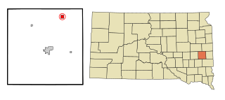
Woonsocket is a city in Sanborn County, South Dakota. The population was 631 at the 2020 census. It is the county seat of Sanborn County.

<span class="mw-page-title-main">Lowry, South Dakota</span> Town in South Dakota, United States

Lowry is a town in Walworth County, South Dakota, United States. The population was 10 at the 2020 census. The town is home to Lowry Pilgrim Community Church, Swan Creek Harness Shop, J & C Repair, Karst Service and a fire station. Lowry also has an abandoned school, and a post office, which closed to service in the early 1970s.

<span class="mw-page-title-main">Westby, Wisconsin</span> City in Wisconsin, United States

Westby is a city in Vernon County, Wisconsin, United States. The population was 2,332 as of the 2020 census. The name "Westby" is a Norwegian name and literally translates to "Western city".

References

  1. "ArcGIS REST Services Directory". United States Census Bureau. Retrieved September 5, 2022.
  2. 1 2 "U.S. Census website". United States Census Bureau . Retrieved November 2, 2021.
  3. "Montana Place Names Companion". Montana Place Names From Alzada to Zortman. Montana Historical Society Research Center. Retrieved May 9, 2011.
  4. Wick, Douglas A. "Westby (Divide County)". North Dakota Place Names. Retrieved May 9, 2011.
  5. "US Gazetteer files: 2010, 2000, and 1990". United States Census Bureau. February 12, 2011. Retrieved April 23, 2011.
  6. "US Gazetteer files 2010". United States Census Bureau. Archived from the original on July 2, 2012. Retrieved December 18, 2012.
  7. Climate Summary for Westby, Montana
  8. "NOWData - NOAA Online Weather Data". National Oceanic and Atmospheric Administration. Retrieved December 15, 2023.
  9. United States Census Bureau. "Census of Population and Housing" . Retrieved July 14, 2016.
  10. "U.S. Census website". United States Census Bureau . Retrieved December 18, 2012.
  11. "U.S. Census website". United States Census Bureau . Retrieved January 31, 2008.
  12. "Westby School District 3". Westby School District. Retrieved April 20, 2021.
  13. "Member Schools". Montana High School Association. Retrieved April 19, 2021.

Commons-logo.svg Media related to Westby, Montana at Wikimedia Commons