Medicine Lake, Montana

Last updated

Medicine Lake, Montana
Sheridan County Montana Incorporated and Unincorporated areas Medicine Lake Highlighted.svg
Location of Medicine Lake, Montana
Coordinates: 48°30′2″N104°30′11″W / 48.50056°N 104.50306°W / 48.50056; -104.50306
Country United States
State Montana
County Sheridan
Area
[1]
  Total0.40 sq mi (1.02 km2)
  Land0.40 sq mi (1.02 km2)
  Water0.00 sq mi (0.00 km2)
Elevation
1,959 ft (597 m)
Population
 (2020)
  Total244
  Density617.72/sq mi (238.42/km2)
Time zone UTC-7 (Mountain (MST))
  Summer (DST) UTC-6 (MDT)
ZIP code
59247
Area code 406
FIPS code 30-48775
GNIS feature ID0774077
Website www.medicinelakemt.com

Medicine Lake is a town in Sheridan County, Montana, United States. The population was 244 at the 2020 census. [2]

Contents

On July 5, 1937, Medicine Lake recorded a temperature of 117 °F (47 °C), setting the record for the highest temperature ever recorded in Montana. [3]

History

Edward Stubban named this place Flandrem for his home town in Norway and established a post office and store in 1906. The town moved about 2 miles with the construction of the Great Northern Railway in 1910. They changed the name to Medicine Lake after the nearby lake the Assiniboine referred to as Bda wauka, “Medicine water.” [4]

On November 14, 2020, the high school football team, which co-ops with Froid, known as the RedHawks, won the 6-man State Championship. They defeated White Sulphur Springs 44–19 to finish the season 10–0. It was the first football state title for the school, which had finished 2nd in 1952, 1985 and 2000, when they were known as the Honkers.[ citation needed ]

On November 20, 2021, the undefeated RedHawks won back to back state titles with a 43–0 defeat of the Power-Dutton-Brady Titans on the road in Dutton, Montana. The win concluded the RedHawks' season with a 13–0 record and extended their winning streak to 23 games.[ citation needed ]

Geography

Medicine Lake is located at 48°30′2″N104°30′11″W / 48.50056°N 104.50306°W / 48.50056; -104.50306 (48.500438, -104.503079). [5]

According to the United States Census Bureau, the town has a total area of 0.40 square miles (1.04 km2), all land. [6]

Climate

According to the Köppen Climate Classification system, Medicine Lake has a semi-arid climate, abbreviated "BSk" on climate maps. [7]

Climate data for Medicine Lake, Montana, 1991–2020 normals, extremes 1911–present
MonthJanFebMarAprMayJunJulAugSepOctNovDecYear
Record high °F (°C)60
(16)
68
(20)
77
(25)
92
(33)
103
(39)
107
(42)
117
(47)
107
(42)
101
(38)
91
(33)
75
(24)
68
(20)
117
(47)
Mean maximum °F (°C)43.3
(6.3)
45.9
(7.7)
60.3
(15.7)
76.5
(24.7)
84.8
(29.3)
90.3
(32.4)
95.4
(35.2)
96.0
(35.6)
91.1
(32.8)
78.1
(25.6)
60.0
(15.6)
45.6
(7.6)
98.2
(36.8)
Mean daily maximum °F (°C)22.1
(−5.5)
26.4
(−3.1)
39.0
(3.9)
54.6
(12.6)
66.5
(19.2)
75.1
(23.9)
82.7
(28.2)
82.6
(28.1)
72.0
(22.2)
55.3
(12.9)
38.2
(3.4)
26.9
(−2.8)
53.5
(11.9)
Daily mean °F (°C)11.0
(−11.7)
15.1
(−9.4)
27.6
(−2.4)
42.1
(5.6)
53.9
(12.2)
62.8
(17.1)
69.1
(20.6)
67.8
(19.9)
57.1
(13.9)
42.3
(5.7)
27.0
(−2.8)
16.1
(−8.8)
41.0
(5.0)
Mean daily minimum °F (°C)−0.1
(−17.8)
3.9
(−15.6)
16.3
(−8.7)
29.6
(−1.3)
41.4
(5.2)
50.6
(10.3)
55.6
(13.1)
53.0
(11.7)
42.1
(5.6)
29.4
(−1.4)
15.8
(−9.0)
5.3
(−14.8)
28.6
(−1.9)
Mean minimum °F (°C)−26.1
(−32.3)
−20.0
(−28.9)
−8.9
(−22.7)
13.0
(−10.6)
25.6
(−3.6)
37.6
(3.1)
43.3
(6.3)
40.1
(4.5)
26.0
(−3.3)
12.6
(−10.8)
−5.0
(−20.6)
−18.5
(−28.1)
−30.6
(−34.8)
Record low °F (°C)−51
(−46)
−58
(−50)
−38
(−39)
−15
(−26)
8
(−13)
22
(−6)
30
(−1)
30
(−1)
9
(−13)
−10
(−23)
−31
(−35)
−46
(−43)
−58
(−50)
Average precipitation inches (mm)0.33
(8.4)
0.16
(4.1)
0.42
(11)
0.93
(24)
2.39
(61)
2.90
(74)
2.65
(67)
1.54
(39)
1.17
(30)
0.89
(23)
0.36
(9.1)
0.32
(8.1)
14.06
(358.7)
Average precipitation days (≥ 0.01 in)3.42.23.85.17.810.58.66.86.15.02.63.165.0
Source 1: NOAA [8]
Source 2: National Weather Service [9]

Demographics

Historical population
CensusPop.Note
1920 292
1930 38431.5%
1940 3963.1%
1950 45414.6%
1960 452−0.4%
1970 393−13.1%
1980 4083.8%
1990 357−12.5%
2000 269−24.6%
2010 225−16.4%
2020 2448.4%
U.S. Decennial Census [10] [2]

2010 census

As of the census [11] of 2010, there were 225 people, 109 households, and 65 families residing in the town. The population density was 562.5 inhabitants per square mile (217.2/km2). There were 167 housing units at an average density of 417.5 per square mile (161.2/km2). The racial makeup of the town was 90.7% White, 0.9% African American, 4.0% Native American, and 4.4% from two or more races.

There were 109 households, of which 24.8% had children under the age of 18 living with them, 40.4% were married couples living together, 12.8% had a female householder with no husband present, 6.4% had a male householder with no wife present, and 40.4% were non-families. 38.5% of all households were made up of individuals, and 14.7% had someone living alone who was 65 years of age or older. The average household size was 2.06 and the average family size was 2.74.

The median age in the town was 48.1 years. 24.4% of residents were under the age of 18; 4.6% were between the ages of 18 and 24; 17.8% were from 25 to 44; 34.8% were from 45 to 64; and 18.7% were 65 years of age or older. The gender makeup of the town was 49.3% male and 50.7% female.

2000 census

As of the census [12] of 2000, there were 269 people, 120 households, and 72 families residing in the town. The population density was 658.8 inhabitants per square mile (254.4/km2). There were 165 housing units at an average density of 404.1 per square mile (156.0/km2). The racial makeup of the town was 92.19% White, 3.72% Native American, 0.37% Asian, 0.37% Pacific Islander, and 3.35% from two or more races.

There were 120 households, out of which 28.3% had children under the age of 18 living with them, 50.0% were married couples living together, 6.7% had a female householder with no husband present, and 40.0% were non-families. 40.0% of all households were made up of individuals, and 15.0% had someone living alone who was 65 years of age or older. The average household size was 2.24 and the average family size was 2.97.

In the town, the population was spread out, with 26.4% under the age of 18, 7.1% from 18 to 24, 22.3% from 25 to 44, 28.3% from 45 to 64, and 16.0% who were 65 years of age or older. The median age was 41 years. For every 100 females there were 116.9 males. For every 100 females age 18 and over, there were 108.4 males.

The median income for a household in the town was $28,750, and the median income for a family was $35,694. Males had a median income of $26,000 versus $26,250 for females. The per capita income for the town was $16,405. About 7.2% of families and 7.2% of the population were below the poverty line, including 6.5% of those under the age of eighteen and 3.4% of those 65 or over.

Education

Medicine Lake School District educates students from kindergarten through 12th grade. [13] Medicine Lake High School's team name is the Redhawks. [14]

Related Research Articles

<span class="mw-page-title-main">Belt, Montana</span> Town in Montana, United States

Belt is a town in Cascade County, Montana, United States. The population was 510 according to the 2020 census. It is part of the Great Falls, Montana metropolitan area.

<span class="mw-page-title-main">Cascade, Montana</span> Town in Cascade County, Montana, United States

Cascade is a town in Cascade County, Montana, United States. The population was 600 at the 2020 census. It is part of the Great Falls, Montana Metropolitan Statistical Area, which in 2020 had a population of 84,414. Cascade was incorporated in 1911.

<span class="mw-page-title-main">Winifred, Montana</span> Town in Montana, United States

Winifred is a small town in rural north-central Fergus County, Montana, United States. It was founded in 1913 and provides services for its region's populace. The town population was 172 at the 2020 census. The current mayor is Travis Willson.

<span class="mw-page-title-main">Jordan, Montana</span> Town in Montana, United States

Jordan is a town in and the county seat of Garfield County, Montana, United States. The population was 356 at the 2020 census. It is Garfield County's only incorporated community.

<span class="mw-page-title-main">Ryegate, Montana</span> Town in Montana, United States

Ryegate is a town in, and the county seat of, Golden Valley County, Montana, United States. The population was 223 at the 2020 census. Ryegate is situated on the north bank of the Musselshell River.

<span class="mw-page-title-main">Whitehall, Montana</span> Town in Montana, United States

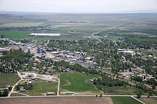
Whitehall is a town in Jefferson County, Montana, United States. The population was 1,006 at the 2020 census. It is part of the Helena Micropolitan Statistical Area.

<span class="mw-page-title-main">Big Arm, Montana</span> Census-designated place in Montana, United States

Big Arm is a census-designated place (CDP) in Lake County, Montana, United States. The population was 177 at the 2010 census, up from 131 in 2000.

<span class="mw-page-title-main">Ravalli, Montana</span> Place in Montana, United States

Ravalli is an unincorporated community in Lake County, Montana, United States. The population was 76 at the 2010 census, down from 119 in 2000. For statistical purposes, the United States Census Bureau has defined Ravalli as a census-designated place (CDP). In the early 1900s, the Pablo-Allard herd in Ravalli was said to be the largest collection of the bison remaining in the U.S. and played a critical role in the conservation of bison.

<span class="mw-page-title-main">St. Ignatius, Montana</span> Town in Montana, United States

St. Ignatius is a town in Lake County, Montana, United States. The population was 768 at the 2020 census. The town is located on the Flathead Indian Reservation.

<span class="mw-page-title-main">East Helena, Montana</span> City in Montana, United States

East Helena is a city in Lewis and Clark County, Montana, United States, approximately 5 miles (8 km) east of downtown Helena. The population was 1,944 at the 2020 census. It is part of the Helena Micropolitan Statistical Area, which includes all of Lewis and Clark and Jefferson counties; its population is 83,058 according to the 2020 Census.

<span class="mw-page-title-main">Rexford, Montana</span> Town in Montana, United States

Rexford is a town in Lincoln County, Montana, United States. The population was 78 at the 2020 census.

<span class="mw-page-title-main">Seeley Lake, Montana</span> CDP in Montana, United States

Seeley Lake is a census-designated place (CDP) in Missoula County, Montana, United States. It is part of the 'Missoula, Montana Metropolitan Statistical Area'. The town sits beside the 1,031.5 acres lake Seeley Lake. The population was 1,682 at the 2020 census.

<span class="mw-page-title-main">Valier, Montana</span> Town in Montana, United States

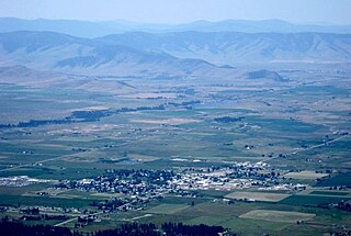
Valier is a town in Pondera County, Montana, United States. The population was 530 at the 2020 census.

<span class="mw-page-title-main">Choteau, Montana</span> City in Montana, United States

Choteau is a city in and the county seat of Teton County, Montana, United States. The population was 1,721 at the 2020 census.

<span class="mw-page-title-main">Sunburst, Montana</span> Town in Montana, United States

Sunburst is a town in Toole County, Montana, United States. The population was 333 in the 2020 census.

<span class="mw-page-title-main">Nashua, Montana</span> Town in Montana, United States

Nashua is a town in Valley County, Montana, United States. The population was 301 at the 2020 census.

<span class="mw-page-title-main">Broadview, Montana</span> Town in Montana, United States

Broadview is a town in Yellowstone County, Montana, United States. The population was 139 at the 2020 census.

<span class="mw-page-title-main">Polson, Montana</span> Town in Montana, United States

Polson is a city in , United States, on the southern shore of Flathead Lake and within the Flathead Indian Reservation. The population was 5,148 at the 2020 census. It is the county seat of Lake County. In 1898 the city was named after pioneer rancher David Polson. It was incorporated in 1910.

<span class="mw-page-title-main">Ronan, Montana</span> City in Montana, United States

Ronan is a city in Lake County, Montana, United States. It is on the Flathead Indian Reservation. The population was 1,955 at the 2020 census.

<span class="mw-page-title-main">Oneida, Tennessee</span> Town in Tennessee, United States

Oneida is a town in Scott County, Tennessee, United States. The population was 3,787 at the 2020 census.

References

  1. "ArcGIS REST Services Directory". United States Census Bureau. Retrieved September 5, 2022.
  2. 1 2 "U.S. Census website". United States Census Bureau . Retrieved November 2, 2021.
  3. "Record Highest Temperatures by State" (PDF). National Climatic Data Center. Archived (PDF) from the original on November 6, 2004. Retrieved May 9, 2011.
  4. "Medicine Lake". Montana Place Names Companion. Montana Historical Society. Retrieved April 7, 2021.
  5. "US Gazetteer files: 2010, 2000, and 1990". United States Census Bureau. February 12, 2011. Retrieved April 23, 2011.
  6. "US Gazetteer files 2010". United States Census Bureau. Archived from the original on January 25, 2012. Retrieved December 18, 2012.
  7. Climate Summary for Medicine Lake, Montana
  8. "U.S. Climate Normals Quick Access – Station: Medicine Lake 3 SE, MT". National Oceanic and Atmospheric Administration. Retrieved October 19, 2023.
  9. "NOAA Online Weather Data – NWS Glasgow". National Weather Service. Retrieved October 19, 2023.
  10. United States Census Bureau. "Census of Population and Housing" . Retrieved July 14, 2016.
  11. "U.S. Census website". United States Census Bureau . Retrieved December 18, 2012.
  12. "U.S. Census website". United States Census Bureau . Retrieved January 31, 2008.
  13. "Medicine Lake School District #7". Medicine Lake School District. Retrieved April 20, 2021.
  14. "Member Schools". Montana High School Association. Retrieved April 19, 2021.