Western Interior Seaway anoxia

Last updated

Three Western Interior Seaway anoxic events occurred during the Cretaceous in the shallow inland seaway that divided North America in two island continents, Appalachia and Laramidia (see map). During these anoxic events much of the water column was depleted in dissolved oxygen. While anoxic events impact the world's oceans, Western Interior Seaway anoxic events exhibit a unique paleoenvironment compared to other basins. The notable Cretaceous anoxic events in the Western Interior Seaway mark the boundaries at the Aptian-Albian, Cenomanian-Turonian, and Coniacian-Santonian stages, and are identified as Oceanic Anoxic Events I, II, and III respectively. The episodes of anoxia came about at times when very high sea levels coincided with the nearby Sevier orogeny that affected Laramidia to the west and Caribbean large igneous province to the south, which delivered nutrients and oxygen-adsorbing compounds into the water column.

Contents

Most anoxic events are recognized using the 13C isotope as a proxy to indicate total organic carbon preserved in sedimentary rocks. If there is very little oxygen, then organic material that settles to the bottom of the water column will not be degraded as readily compared to normal oxygen settings and can be incorporated into the rock. 13Corganic is calculated by comparing the amount of 13C to a carbon isotope standard, and using multiple samples can track changes (δ) in organic carbon content through rocks over time, forming a δ13Corganic curve. The δ13Corganic, as a result, serves as a benthic oxygen curve.

The excellent organic carbon preservation brought about by these successive anoxic events makes Western Interior Seaway strata some of the richest source rocks for oil and gas.

Farallon, Kula, and North American plate distribution between 64 and 74 million years ago. Arrows represent vectors (magnitude and direction) of plate motion. Black represents present-day land area. North America subduction.jpg
Farallon, Kula, and North American plate distribution between 64 and 74 million years ago. Arrows represent vectors (magnitude and direction) of plate motion. Black represents present-day land area.

Western Interior Seaway tectonics and geography

During the Cretaceous Period, along the western shore of the Western Interior Seaway there was active volcanism and foreland subsidence brought about by the Sevier orogeny, formed by the convergence of the oceanic Farallon and Kula plates with the North American plate. [1] Active volcanism during the Sevier orogeny was the product of partial melting of the subducting Farallon and Kula plates: that resulting melt traveled up through the overlying North American plate, creating a belt of active volcanos. Most active volcanism occurred in the extreme northern and southern portions of the western shoreline of the Western Interior Seaway. [1]

To the east of the orogeny, a back-arc basin formed due to the warping of the North American plate in response to the horizontal stress of the subducting oceanic plates. The low-lying area was under water throughout the Cretaceous due to the warm climate causing the planet's ocean waters to expand and flood the continent's interior. Sea level during Oceanic Anoxic Event II at the Cenomanian-Turonian boundary was at its highest of the Cretaceous due to high global temperatures. At that time, the Western Interior Seaway stretched from the Boreal Sea (present Arctic Sea) to the Tethys Sea (present Gulf of Mexico), making it 6000 km long and 2000 km wide. [2] [3] [4] The deepest portions were around 500 m deep. [3]

Formation of the Caribbean Plate in the Tethys Sea near the southern region of the Western Interior Seaway created a large igneous province (called the Caribbean Plateau) that produced underwater lava flows from 95-87 million years ago. [5]

Anoxic events

External image
Searchtool.svg nature.com A flow chart of magma sourcing trace metals, ocean fertilization, stratification, and anoxia.

Nutrient sourcing

Ash and dissolved trace metals from Sevier and Caribbean eruptions provided nutrients to the water column, which was the driving mechanism for anoxia in the Western Interior Seaway. [6] Ash from volcanic eruptions is the source of thick bentonite layers in Western Interior Seaway strata. Ash contains trace metals that, while in low concentration, provide nutrients to microorganisms that live in the water column. Caribbean Plateau lavas sourced hydrothermal fluids containing trace metals and sulfides. Together both events enriched the chemistry of the water column by fertilizing the photosynthesizing microorganisms, which are the ocean's primary producers. Increases in primary production will affect the rest of the water column by increasing the biomass (the density of organisms in a certain volume), which will use up much of the available oxygen both during metabolism and once dead, during the processes of decay. Additionally, dissolved oxygen passively binds to metals and sulfides, further depleting the oxygen in the water column. [6]

Stratification

A significant loss of oxygen leads to environmental perturbations. Water column stratification can occur when the zone below the sediment-water interface that is normally devoid of oxygen moves up above the sediment and into the water column. While this is a common phenomenon in deep water, this is interpreted to have occurred during anoxic settings in the shallow Western Interior Seaway as evidenced by extinctions of benthic fauna at the Cenomanian-Turonian Boundary Event brought about by Oceanic Anoxic Event II. The extinction can be explained by ocean stratification causing low-oxygen conditions in the benthic zone. Further, increasing primary production of marine plankton causes an excess of metabolic waste products, notably overproduction of CO2 during processes of organic decay. When CO2 combines with water molecules it reduces the alkalinity of seawater. Eventually the ocean can become so acidified that calcite cannot be incorporated into the hard parts of shelly organisms (biomineralized) and therefore toxic to live in. [7]

A look down the Western Interior Seaway during Oceanic Anoxic Event II. The structure of the North American plate and sea level (blue line) projected over the United States of America (red line) with nutrient sourcing from volcanoes along the convergent margin, and the resulting water column stratification (green) and its extent throughout the basin (dashed green line). Western Interior Seaway during Oceanic Anoxic Event II.png
A look down the Western Interior Seaway during Oceanic Anoxic Event II. The structure of the North American plate and sea level (blue line) projected over the United States of America (red line) with nutrient sourcing from volcanoes along the convergent margin, and the resulting water column stratification (green) and its extent throughout the basin (dashed green line).
The Corganic Curve for the duration of Oceanic Anoxic Event II (OAE II, highlighted in green)showing change in Corganic compared to a standard (Vienna Pee Dee Belemnite) through time (y-axis) across the Cenomanian-Turonian Stage Boundary (about 93.9 million years ago). 13Corganic Curve for OAE II.png
The Corganic Curve for the duration of Oceanic Anoxic Event II (OAE II, highlighted in green)showing change in Corganic compared to a standard (Vienna Pee Dee Belemnite) through time (y-axis) across the Cenomanian-Turonian Stage Boundary (about 93.9 million years ago).

Alternate theories to anoxic events in the Western Interior Seaway

Oceanic Anoxic Event II

Western Interior Seaway strata preserve the positive13Corganic excursion during Oceanic Anoxic Event II, meaning there was excellent preservation of organic carbon. However, other evidence is conflicting. Molybdenum, an oxygen-sensitive trace metal, will be present in unoxidized form in strata only if there is anoxia. One study showed lack of molybdenum in Oceanic Anoxic Event II strata. [8] Other studies demonstrated the persistence of benthic organisms that could not live in anoxic settings throughout the entirety of Oceanic Anoxic Event II. [7] Consequently, there is a difference in opinion of the relationship between benthic oxygen conditions and what a positive shift of the 13Corganic curve represents. Anoxia in the Western Interior Seaway during Oceanic Anoxic Event II is still an enigma.

Anoxic vs. dysoxic hypothesis

Oceanic Anoxic Event II is believed to have caused the longest duration and most potent water column stratification in Western Interior Seaway history. [8] Although there has been much research devoted to Western Interior Seaway strata, the impact of Oceanic Anoxic Event II on the oxygen content of the benthic zone is still contested. [6] [9] [10] Some relatively recent research suggests that Western Interior Seaway waters during Oceanic Anoxic Event II were dysoxic (2.0 - 0.2 mL of O2/L of H2O[with oxic being > 2.0 mL of O2/L]) rather than anoxic (< 0.2 mL of O2/L of H2O). [11] Dysoxic water can be interpreted as having a moderate amount of oxygen, or oxygen varying through time between oxic and anoxic, oxic and dysoxic, or dysoxic and anoxic conditions. If the benthic oxygen was variable, the rates of change in the oxygen will affect organic carbon preservation, benthic fossil abundance and diversity, and oxygen-sensitive trace metal concentrations.

Circulation models

It has been argued that the Western Interior Seaway could have had patches of anoxia, or places where water is stratified. This would be represented by variations in 13Corganic levels in rocks deposited at the same time in different parts of the seaway. [7]

Some models of Western Interior Seaway water circulation indicate that waters were homogenously mixed and not stratified. [12] The seaway, when modeled as a large bay, can have a very broad gyre formed from moving warm salt-rich water from the Tethys northward along the eastern shore, and cool Boreal waters southward along the western shore. While waters of differing salinity and temperatures could become stratified, models predict that the seaway was well-mixed due to the circulation gyre.

Related Research Articles

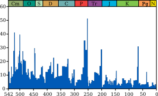
The Cretaceous is a geological period that lasted from about 145 to 66 million years ago (Mya). It is the third and final period of the Mesozoic era, as well as the longest. At nearly 80 million years, it is the longest geological period of the entire Phanerozoic. The name is derived from the Latin creta, "chalk", which is abundant in the latter half of the period. It is usually abbreviated K, for its German translation Kreide.

The Mesozoic Era, also called the Age of Reptiles and the Age of Conifers, is the second-to-last era of Earth's geological history, lasting from about 252 to 66 million years ago and comprising the Triassic, Jurassic and Cretaceous periods. It is characterized by the dominance of archosaurian reptiles, like the dinosaurs; an abundance of conifers and ferns; a hot greenhouse climate; and the tectonic break-up of Pangaea. The Mesozoic is the middle of three eras since complex life evolved: the Paleozoic, the Mesozoic, and the Cenozoic.

Permian–Triassic extinction event Earths most severe extinction event

The Permian–Triassicextinction event, also known as the End-Permian Extinction and colloquially as the Great Dying, formed the boundary between the Permian and Triassic geologic periods, as well as between the Paleozoic and Mesozoic eras, approximately 251.9 million years ago. It is the Earth's most severe known extinction event, with the extinction of 57% of biological families, 83% of genera, 81% of marine species and 70% of terrestrial vertebrate species. It was the largest known mass extinction of insects.

Ordovician–Silurian extinction events Mass extinction event at the end of the Ordovician period and the beginning of the Silurian period in the Paleozoic era, around 444 million years ago

The Ordovician–Silurian extinction events, also known as the Late Ordovician mass extinction, are collectively the second-largest of the five major extinction events in Earth's history in terms of percentage of genera that became extinct. Extinction was global during this period, eliminating 49–60% of marine genera and nearly 85% of marine species. Only the Permian-Triassic mass extinction exceeds the Late Ordovician mass extinction in biodiversity loss. The extinction event abruptly affected all major taxonomic groups and caused the disappearance of one third of all brachiopod and bryozoan families, as well as numerous groups of conodonts, trilobites, echinoderms, corals, bivalves, and graptolites. This extinction was the first of the "big five" Phanerozoic mass extinction events and was the first to significantly affect animal-based communities. However, the Late Ordovician mass extinction did not produce major changes to ecosystem structures compared to other mass extinctions, nor did it lead to any particular morphological innovations. Diversity gradually recovered to pre-extinction levels over the first 5 million years of the Silurian period.

Western Interior Seaway Large prehistoric inland sea that split the continent of North America

The Western Interior Seaway was a large inland sea that existed during the mid- to late Cretaceous period as well as the very early Paleogene, splitting the continent of North America into two landmasses, Laramidia to the west and Appalachia to the east. The ancient sea stretched from the Gulf of Mexico and through the middle of the modern-day countries of the United States and Canada, meeting with the Arctic Ocean to the north. At its largest, it was 2,500 feet (760 m) deep, 600 miles (970 km) wide and over 2,000 miles (3,200 km) long.

Anoxic event Intervals in the Earths past where parts of oceans were depleted of oxygen at depth over a large geographic area

Oceanic anoxic events or anoxic events (anoxia conditions) describe periods wherein large expanses of Earth's oceans were depleted of dissolved oxygen (O2), creating toxic, euxinic (anoxic and sulphidic) waters. Although anoxic events have not happened for millions of years, the geological record shows that they happened many times in the past. Anoxic events coincided with several mass extinctions and may have contributed to them. These mass extinctions include some that geobiologists use as time markers in biostratigraphic dating. On the other hand, there are widespread, various black-shale beds from the mid-Cretaceous which indicate anoxic events but are not associated with mass extinctions. Many geologists believe oceanic anoxic events are strongly linked to the slowing of ocean circulation, climatic warming, and elevated levels of greenhouse gases. Researchers have proposed enhanced volcanism (the release of CO2) as the "central external trigger for euxinia."

The Cenomanian is, in the ICS' geological timescale, the oldest or earliest age of the Late Cretaceous epoch or the lowest stage of the Upper Cretaceous series. An age is a unit of geochronology; it is a unit of time; the stage is a unit in the stratigraphic column deposited during the corresponding age. Both age and stage bear the same name.

Geology of the Dallas–Fort Worth Metroplex

The Dallas–Fort Worth Metroplex sits above Cretaceous-age strata ranging from ≈145-66 Ma. These Cretaceous-aged sediments lie above the eroded Ouachita Mountains and the Fort Worth Basin, which was formed by the Ouachita Orogeny. Going from west to east in the DFW Metroplex and down towards the Gulf of Mexico, the strata get progressively younger. The Cretaceous sediments dip very gently to the east.

Anoxic waters are areas of sea water, fresh water, or groundwater that are depleted of dissolved oxygen and are conditions of hypoxia. The US Geological Survey defines anoxic groundwater as those with dissolved oxygen concentration of less than 0.5 milligrams per litre. This condition is generally found in areas that have restricted water exchange.

Cariaco Basin

The Cariaco Basin lies off the north central coast of Venezuela and forms the Gulf of Cariaco. It is bounded on the east by Margarita Island, Cubagua Island, and the Araya Peninsula; on the north by Tortuga Island and the Tortuga Banks; on the west by Cape Codera and the rocks known as Farallón Centinela; and on the south by the coast of Venezuela.

<i>Ptychodus</i> Extinct genus of sharks

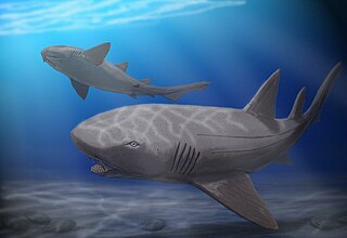
Ptychodus is a genus of extinct sharks. As well as a genus of durophagous (shell-crushing) sharks from the Late Cretaceous. Fossils of Ptychodus teeth are found in many Late Cretaceous marine sediments. There are many species among the Ptychodus that have been uncovered on all the continents around the globe. Such species are Ptychodus mortoni, P. decurrens, P. marginalis, P. mammillaris, P. rugosus and P. latissimus to name a few. They died out approximately 85 million years ago in the Western Interior Sea, where a majority of them were found. A recent publication found that Ptychodus are likely neoselachians, rather than hybodonts or batoids as previously thought. Their life history coincides with the typical life of many other large sharks: they live long lives, they produce large offspring, they produce small litters, and their rate of growth is slow.

Cretaceous Thermal Maximum Period of climatic warming that reached its peak approximately 90 million years ago

The Cretaceous Thermal Maximum (CTM), also known as Cretaceous Thermal Optimum, was a period of climatic warming that reached its peak approximately 90 million years ago during the Turonian age of the Late Cretaceous epoch. The CTM is notable for its dramatic increase in global temperatures characterized by high carbon dioxide levels.

Tropic Shale

The Tropic Shale is a Mesozoic geologic formation. Dinosaur remains are among the fossils that have been recovered from the formation, including Nothronychus graffami. The Tropic Shale is a stratigraphic unit of the Kaiparowits Plateau of south central Utah. The Tropic Shale was first named in 1931 after the town of Tropic where the Type section is located. The Tropic Shale outcrops in Kane and Garfield counties, with large sections of exposure found in the Grand Staircase-Escalante National Monument.

Straight Cliffs Formation

The Straight Cliffs Formation is a stratigraphic unit in the Kaiparowits Plateau of south central Utah. It is Late Cretaceous in age and contains fluvial, paralic, and marginal marine (shoreline) siliciclastic strata. It is well exposed around the margin of the Kaiparowits Plateau in the Grand Staircase – Escalante National Monument in south central Utah. The formation is named after the Straight Cliffs, a long band of cliffs creating the topographic feature Fiftymile Mountain.

<i>Cardabiodon</i> Extinct genus of sharks

Cardabiodon is an extinct genus of large mackerel shark that lived about 95 to 91 million years ago (Ma) during the Cenomanian to Turonian of the Late Cretaceous. It is a member of the Cardabiodontidae, a family unique among mackerel sharks due to differing dental structures, and contains the two species C. ricki and C. venator. Cardabiodon fossils have been found in Australia, North America, England, and Kazakhstan. It was likely an antitropical shark that inhabited temperate neritic and offshore oceans between 40° and 60° paleolatitude, similar to the modern porbeagle shark.

The Cenomanian-Turonian boundary event, or the Cenomanian-Turonian extinction event, the Cenomanian-Turonian anoxic event, and referred also as the Bonarelli event, was one of two anoxic extinction events in the Cretaceous period. Selby et al. in 2009 concluded the OAE 2 occurred approximately 91.5 ± 8.6 Ma, though estimates published by Leckie et al. (2002) are given as 93–94 Ma. The Cenomanian-Turonian boundary has been refined in 2012 to 93.9 ± 0.15 Ma There was a large carbon disturbance during this time period. However, apart from the carbon cycle disturbance, there were also large disturbances in the oxygen and sulfur cycles of the ocean.

Hypoxia (environmental) Low environmental oxygen levels

Hypoxia refers to low oxygen conditions. Normally, 20.9% of the gas in the atmosphere is oxygen. The partial pressure of oxygen in the atmosphere is 20.9% of the total barometric pressure. In water, oxygen levels are much lower, approximately 7 ppm 0.0007% in good quality water, and fluctuate locally depending on the presence of photosynthetic organisms and relative distance to the surface.

Eagle Ford Group

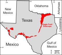
The Eagle Ford Group is a sedimentary rock formation deposited during the Cenomanian and Turonian ages of the Late Cretaceous over much of the modern-day state of Texas. The Eagle Ford is predominantly composed of organic matter-rich fossiliferous marine shales and marls with interbedded thin limestones. It derives its name from outcrops on the banks of the West Fork of the Trinity River near the old community of Eagle Ford, which is now a neighborhood within the city of Dallas. The Eagle Ford outcrop belt trends from the Oklahoma-Texas border southward to San Antonio, westward to the Rio Grande, Big Bend National Park, and the Quitman Mountains of West Texas. It also occurs in the subsurface of East Texas and South Texas, where it is the source rock for oil found in the Woodbine, Austin Chalk, and the Buda Limestone, and is produced unconventionally in South Texas and the "Eaglebine" play of East Texas. The Eagle Ford was one of the most actively drilled targets for unconventional oil and gas in the United States in 2010, but its output had dropped sharply by 2015. By the summer of 2016, Eagle Ford spending had dropped by two-thirds from $30 billion in 2014 to $10 billion, according to an analysis from the research firm Wood Mackenzie. This strike has been the hardest hit of any oil fields in the world. The spending was, however, expected to increase to $11.6 billion in 2017. A full recovery is not expected any time soon.

Favel Formation

The Favel Formation is a stratigraphic unit of Late Cretaceous age. It is present in southern Manitoba and southeastern Saskatchewan, and consists primarily of calcareous shale. It was named for the Favel River near Minitonas, Manitoba, by R.T.D. Wickenden in 1945.

Euxinia or euxinic conditions occur when water is both anoxic and sulfidic. This means that there is no oxygen (O2) and a raised level of free hydrogen sulfide (H2S). Euxinic bodies of water are frequently strongly stratified, have an oxic, highly productive, thin surface layer, and have anoxic, sulfidic bottom water. The word euxinia is derived from the Greek name for the Black Sea (Εὔξεινος Πόντος (Euxeinos Pontos)) which translates to "hospitable sea". Euxinic deep water is a key component of the Canfield ocean, a model of oceans during the Proterozoic period (known as the Boring Billion) proposed by Donald Canfield, an American geologist, in 1998. There is still debate within the scientific community on both the duration and frequency of euxinic conditions in the ancient oceans. Euxinia is relatively rare in modern bodies of water, but does still happen in places like the Black Sea and certain fjords.

References

  1. 1 2 Shurr, G.W., Ludvigson, G.A., Hammond, R.H. 1994. Perspectives on the Eastern Margin of the Cretaceous Western Interior Basin. Geological Society of America, Boulder: Special Paper #287, 264 p.
  2. Slingerland , R.L., Kump, L.R, Arthur, M.A., Fawcett, P.J., Sageman, B.B., and Barron, E.J. 1996. Geological Society of America Bulletin, 108, 941-952.
  3. 1 2 Bowman, A.R. and Gale, A.S., Hardenbol, J., Hathaway, B., Kennedy, W.J., Young, J.R., and Phansalkar, V. 2002. Global correlation of Cenomanian (Upper Cretaceous) sequences: Evidence for Milankovitch control on sea level. Geology, 30, 291-294.
  4. Bralower, T.J. 2005. Paleoceanographic significance of high-resolution carbon isotope records across the Cenomanian-Turonian boundary in the Western Interior and New Jersey coastal plain, USA. Marine Geology, 217, 305-321.
  5. Bralower, T.J. 2008. Volcanic cause of catastrophe. Nature, 454, 285-287.
  6. 1 2 3 Sageman, B.B., Meyers, S.R., and Arthur, M.A. 2006. Orbital time scale and new C-isotope record for Cenomanian-Turonian boundary stratotype. Geology, 34, 125-128.
  7. 1 2 3 Henderson, R.A. 2004. A Mid-Cretaceous association of shell beds and organic rich shale:bivalve exploitation of nutrient-rich, anoxic sea-floor environment. Palaios, 19, 156-169.
  8. 1 2 Meyers, S.R., Sageman, B.B., and Lyons, T.W. 2005. Organic carbon burial rate and the molybdenum proxy: Theoretical framework and application to Cenomanian-Turonian oceanic anoxic event 2. Paleoceanography, 20, PA2002. doi:10.1029/2004PA001068
  9. Keller, G., Berner, Z., Adatte, T., and Stueben, D. 2004. Cenomanian-Turonian and δ13C, and δ18O, sea level and salinity variations at Pueblo, Colorado. Palaeogeography,Palaeoclimatology, Palaeoecology, 211, 19-43.
  10. Kennedy, W.J., Walaszczyk, I., and Cobban, W.A. 2005. The Global Boundary Stratotype Section and Point for the base of the Turonian Stage of the Cretaceous: Pueblo, Colorado, U.S.A. Episodes: Journal of International Geoscience, 28, 93-104.
  11. Tyson, R.V. and Pearson, T.H. 1991. Modern and ancient continental shelf anoxia: an overview.Geological Society, London, Special Publications, 58, 1-24. doi:10.1144/GSL.SP.1991.058.01.01
  12. Slingerland , R.L., Kump, L.R, Arthur, M.A., Fawcett, P.J., Sageman, B.B., and Barron, E.J. 1996. Geological Society of America Bulletin, 108, 941-952.