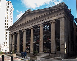
The Westminster Arcade is a historic shopping center at 130 Westminster Street and 65 Weybosset Street in downtown Providence, Rhode Island built in 1828. It is notable as the first enclosed shopping mall in the United States and has been lauded as a fine example of commercial Greek Revival architecture. It served as a shopping center for many years before falling into decline in the late 20th century. It has since been closed for renovation and rehabilitation several times, and most recently reopened its doors in October 2013 as a residential and commercial mixed-use building. It was declared a National Historic Landmark in 1976.

Downtown is the central economic, political, and cultural district of the city of Providence, Rhode Island. It is bounded on the east by Canal Street and the Providence River, to the north by Smith Street, to the west by Interstate 95, and to the south by Henderson Street. I-95 serves as a physical barrier between the city's commercial core and neighborhoods of Federal Hill, West End, and Upper South Providence. Most of the downtown is listed on the National Register of Historic Places as the Downtown Providence Historic District.
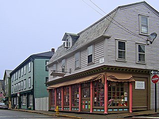
The Newport Historic District is a historic district that covers 250 acres in the center of Newport in the U.S. state of Rhode Island. It was designated a National Historic Landmark (NHL) in 1968 due to its extensive and well-preserved assortment of intact colonial buildings dating from the early and mid-18th century. Six of those buildings are themselves NHLs in their own right, including the city's oldest house and the former meeting place of the colonial and state legislatures. Newer and modern buildings coexist with the historic structures.

The Smith Hill Historic District is a historic district located in northwestern Providence, Rhode Island, just west of the Rhode Island State House and Interstate 95. It includes 57-65 Brownell Street, 73-114 Holden Street, 23-80 Jewett Street, 189-240 Smith Street and 10-18 W. Park Street. This area is a densely built residential section, an isolated remnant of what was once a larger residential area. Most of the 41 properties are residential units built between 1870 and 1930, and are typically 2-1/2 or 3-1/2 stories in height. They are set on lot sizes ranging generally from 3000 to 5000 square feet, and are set close to the sidewalk. The only major non-residential buildings are St. Patrick's School at 244 Smith Street and "The Mohican" at 185-189 Smith Street; the latter is an Art Deco brick and concrete commercial block two stories in height.

Honan's Block and 112–114 Main Street are a pair of joined commercial buildings in Woonsocket, Rhode Island. Honan's Block is a visually distinctive three-story brick Stick/Eastlake-style building erected in 1879. The adjacent 112–114 Main Street is an L-shaped two-story block which wraps around the rear of the Honan Block. The two buildings were joined via internal connections in 1938–39, at which time the facades of both buildings were significantly altered, although the Honan Block has retained its distinctive Late Victorian cast-iron elements.

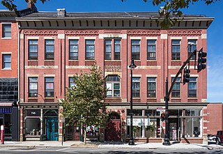
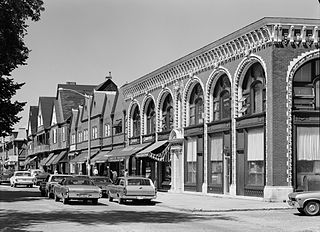
The Main Street Historic District is a historic district in the central business district of Woonsocket, Rhode Island, USA. It extends along Main Street, between the railroad tracks just northeast of its junction with Clinton Street, and roughly Ascension Street at the southwest. Most of the sixteen buildings in this area were built at the height of Woonsocket's prosperity, roughly between 1850 and 1930. The district is characterized by brick and masonry buildings generally between two and six stories in height.

The South Central Falls Historic District is a historic district in Central Falls, Rhode Island. It is a predominantly residential area, densely populated, which was developed most heavily in the late 19th century. It is bounded roughly by Broad Street to the east, the Pawtucket city line to the south, Dexter Street to the west, and Rand Street and Jenks Park to the north. It has 377 contributing buildings, most of which were built before 1920. The district was added to the National Register of Historic Places in 1991.

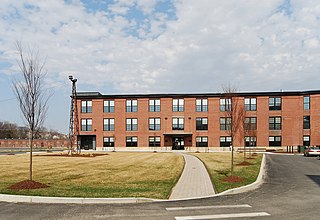
The Aylesworth Apartments is a historic apartment building in Providence, Rhode Island.
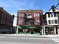
The Burrows Block is an historic commercial building at 735-745 Westminster Street in Providence, Rhode Island. It is a three-story brick building with Gothic Revival styling. It was built in 1880 by Caleb Burrows to provide office space for his hardware business, with retail spaces on the ground floor. Although the hardware business declined in the 20th century, the building has seen a variety of commercial and retail tenants, and was purchased by the city in 2002.
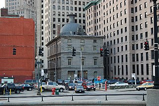
The Customhouse Historic District is a historic district encompassing fifteen historic buildings in downtown Providence, Rhode Island. The district is bounded by Westminster, Exchange, Dyer, Pine, and Peck Streets, and includes eight buildings associated with the important functions of the business center Providence became in the mid-to-late 19th century. It was listed on the National Register of Historic Places in 1975, and is completely contained within the Downtown Providence Historic District, listed in 1984.

Grace Church is an historic Episcopal church at 175 Mathewson Street at Westminster Street, in downtown Providence, Rhode Island.

The Hope–Power–Cooke Streets Historic District is a residential historic district on the East Side of Providence, Rhode Island. Located east of Brown University, the area is compact area developed in the mid-to-late 19th century as a residential district, with a cross-section of architectural styles from the early 19th to the early 20th century. The district is bounded on the north by Angell Street, on the east by Governor Street, on the south by Power Street, and on the west by Hope Street. Cooke Street is the main thorough fare running through the center of the district, which is six blocks long and two wide. The district abuts the Stimson Avenue Historic District, which lies immediately to its west.

The Market House is a historic three-story brick market house in Market Square, in the College Hill, a neighborhood of Providence, Rhode Island, USA. The building was constructed between 1773 and 1775 and designed by prominent local architects, Joseph Brown and Declaration of Independence signer Stephen Hopkins. The bottom floor of the house was used as a market, and the upper level was used for holding meetings. Similar buildings existed in other American cities, such as Faneuil Hall in Boston and the Old Brick Market in Newport. The building housed the Providence City Council in the decades before the completion of City Hall.
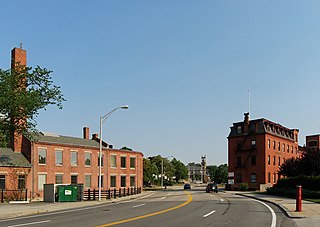
Moshassuck Square is an industrial historic district in Providence, Rhode Island, lining the banks of the Blackstone Canal just north of the Rhode Island State House. It consists of the few surviving buildings of the once-extensive American Screw Company complex, which was largely developed between the 1840s and 1870s, and was a major fixture in the Providence landscape prior to its destruction by fire in 1971. The buildings are in an area bounded by Charles Street on the west, Stevens and Hewes Streets on the north, North Main Street to the east, and Mill Street to the south. Prominent among them are the Stillman White Foundry and Fletcher Manufacturing Company office building, which stand on opposite sides of Mill Street near its crossing of the canal. At 127 Charles Street stands a three-story brick building built c. 1900 as a retail and residential building. The only surviving elements of the Screw Company complex are located at North Main and Hewes Streets, and now house the Providence Center.
The Power Street–Cooke Street Historic District is a residential historic district on the East Side of Providence, Rhode Island. Located east of Brown University, the area is compact area developed in the mid-to-late 19th century as a residential district, with a cross-section of architectural styles from the early 19th to the early 20th century. The district is bounded on the north by Angell Street, on the east by Governor Street, on the south by Power Street, and on the west by Hope Street. Cooke Street is the main thorough fare running through the center of the district, which is six blocks long and two wide. The district abuts the Stimson Avenue Historic District, which lies immediately to its west.

The Providence Jewelry Manufacturing Historic District is a predominantly industrial historic district in Providence, Rhode Island. It covers a roughly 19-acre (7.7 ha) area just south of Downtown Providence, and was originally bounded by Interstate 195 prior to a realignment in the 2000s which reconnected the two areas. Although the area began as a residential area, and still has some houses in it, it developed in the late 19th and early 20th centuries as a center of Providence's jewelry manufacturing businesses. The oldest industrial building in the district is the 1848 Elm Street Machine Shop, a 2 1⁄2-story stone structure that now houses offices of Brown University.

The Reservoir Avenue Sewage Pumping Station is an historic wastewater pumping facility on the south side of the junction of Reservoir and Pontiac Avenues in southern Providence, Rhode Island. From the street it looks like a single-story brick structure with a hip roof, and metal doorways on its north and east elevations. This building stands atop a substantial concrete substructure, which houses a dry well and wet well. The dry well, on the eastern side, houses the pumps, while the wet well, occupies the western two-thirds of the facility. The floor of the interior includes glass blocks for viewing the facilities below, as well as metal trapdoors for accessing the pumps. Manual gate valves on the west side are used to control sewage flow through the west well. This facility is used to pump raw sewage eastward and uphill to a gravity conduit in Rutherglen Avenue. This conduit carries the sewage to the Field's Point treatment facility. The pumping station was built by the city of Providence in 1931, and is now owned by the Narragansett Bay Commission, which operates the region's wastewater treatment facilities.
The United States Rubber Company Mill Complex is a historic industrial facility in Providence, Rhode Island. It is a large complex of factory buildings covering about 23 acres (9.3 ha) on the north bank of the Woonasquatucket River. It is bounded on the west by Ericson Place, the north by Valley Street, and the east by Hemlock Street. The property includes 29 historic buildings, built between c. 1885 and c. 1960, as well as three bridges. The buildings are predominantly brick structures, ranging in height from one to five stories, and were built either by the Joseph Banigan Rubber Company, its successor the United States Rubber Company, or the American Locomotive Company, whose property east of the rubber works was acquired by the US Rubber Company in 1918. Only four buildings built by these companies are known to have been demolished before 1960. The plant closed in 1975, and has since been adapted to a variety of other uses.

The Weybosset Mills Complex is a historic industrial site in the Olneyville section of Providence, Rhode Island. It consists of nine historic brick factory buildings, located on three city blocks west of Rhode Island Route 10 and north of United States Route 6, just northwest of their junction. The three blocks are bounded on the south by Magnolia Street, and on the east by railroad tracks paralleling Route 10. The southern two blocks end at Agnes and Oak Streets, while the northerly block is bounded on the west by Troy Street and the north by Dike Street. The oldest building in the complex is a three-story brick boiler house built c. 1836. Although the origins of this mill complex were as a cotton mill, the Weybosset Corporation purchased it in 1864, and transformed it into one of the nation's major producers of worsted wool products.
The Bellevue Avenue/Casino Historic District encompasses a one-block section of Bellevue Avenue in Newport, Rhode Island. Although Bellevue Avenue is best known for the large number of Gilded Age mansions which line it, this block is a coherent collection of commercial buildings at the northern end of the mansion row. It is anchored around the Newport Casino, now the International Tennis Hall of Fame, and includes three other buildings on the east side of Bellevue Avenue between Memorial Boulevard and East Bowery Street.