Wetlet ဝက်လက် | |
---|---|
Town | |
Coordinates: 22°22′28″N95°47′28″E / 22.37444°N 95.79111°E Coordinates: 22°22′28″N95°47′28″E / 22.37444°N 95.79111°E | |
Country | |
Region | |
District | Shwebo District |
Township | Wetlet Township |
Elevation | 84 m (278 ft) |
Time zone | MST (UTC+6.30) |
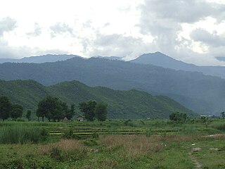
Wetlet (Burmese : ဝက်လက်) is a town in Shwebo District, Sagaing Division in Myanmar. It is the administrative seat for Wetlet Township. The town of Wetlet is located in the center of Wetlet Township, about halfway between the Mu River and the Irrawaddy. Wetlet is on the main Burmese north-south railroad between Sagaing and Shwebo. [1]
The Burmese language is the Sino-Tibetan language spoken in Myanmar where it is an official language and the language of the Bamar people, the country's principal ethnic group. Although the Constitution of Myanmar officially recognizes the English name of the language as the Myanmar language, most English speakers continue to refer to the language as Burmese, after Burma, the older name for Myanmar. In 2007, it was spoken as a first language by 33 million, primarily the Bamar (Burman) people and related ethnic groups, and as a second language by 10 million, particularly ethnic minorities in Myanmar and neighboring countries.
Shwebo District is a district in south-central Sagaing Division of Burma (Myanmar). Its administrative center is the city of Shwebo.
Myanmar, officially the Republic of the Union of Myanmar and also known as Burma, is a country in Southeast Asia. Myanmar is bordered by India and Bangladesh to its west, Thailand and Laos to its east and China to its north and northeast. Myanmar is the largest of the mainland Southeast Asian states.To its south, about one third of Myanmar's total perimeter of 5,876 km (3,651 mi) forms an uninterrupted coastline of 1,930 km (1,200 mi) along the Bay of Bengal and the Andaman Sea. The country's 2014 census counted the population to be 51 million people. As of 2017, the population is about 54 million. Myanmar is 676,578 square kilometres in size. Its capital city is Naypyidaw, and its largest city and former capital is Yangon (Rangoon). Myanmar has been a member of the Association of Southeast Asian Nations (ASEAN) since 1997.
Wetlet originated as a staging area during the building of the railroad in the late 1800s. A well was dug to provide water for the steam engines, and a small market developed around Wetlet station. Because of its central location, and direct rail access, Wetlet became the leading town in the area.
This Shwebo District location article is a stub. You can help Wikipedia by expanding it. |
Sagaing Region is an administrative region of Myanmar, located in the north-western part of the country between latitude 21° 30' north and longitude 94° 97' east. It is bordered by India’s Nagaland, Manipur, and Arunachal Pradesh States to the north, Kachin State, Shan State, and Mandalay Region to the east, Mandalay Region and Magway Region to the south, with the Ayeyarwady River forming a greater part of its eastern and also southern boundary, and Chin State and India to the west. The region has an area of 93,527 km2. In 1996, it had a population of over 5,300,000 while its population in 2012 was 6,600,000. The urban population in 2012 was 1,230,000 and the rural population was 5,360,000. The capital is Sagaing.
Htigyaing, also spelt Tigyaing, is a town in eastern Sagaing Division, in northern Myanmar. It is a port on the Irrawaddy River and the administrative seat of Tigyaing Township.
Kanbalu is a town in Shwebo District, Sagaing Division, in Myanmar. It is the administrative seat for Kanbalu Township. Kanbalu is on the main Burmese north-south railroad between Sagaing and Myitkyina.
Ye-U is a town in the Shwebo District of the Sagaing Division in Myanmar.
Tabayin is a town in the Sagaing Division in Myanmar.
Shwebo Township is a township of Shwebo District in the Sagaing Region of Burma (Myanmar). It is located on the plains between the Mu River and the Ayeyarwady River. The ancient palace of King Alaungmintaya is being excavated there. Its administrative seat is the city of Shwebo.
Mingin Township is a township of Kale District in Sagaing Division of Burma (Myanmar). The principal town and administrative seat is Mingin (Minking).
Mawlaik District is a district in central Sagaing Division of Burma (Myanmar). Its administrative center is the town of Mawlaik.
Wetlet Township is a township of Shwebo District in the Sagaing Division of Burma (Myanmar). It is located on the plains between the Mu River and the Irrawaddy. Its administrative seat is the town of Wetlet.
Kale District is the westernmost district in Sagaing Division of Myanmar (Burma).
Monywa District is an administrative district in southern Sagaing Division, Burma (Myanmar). Its administrative center is the city of Monywa.
Tabayin Township is a township in Shwebo District in the Sagaing Division of Burma. The principal town is Tabayin.
Khin-U Township is a township in Shwebo District in the Sagaing Division of Burma.The principal town is Khin-U.
Ye-U Township is a township in Shwebo District in the Sagaing Division of Burma. The principal town is Ye-U.
Hladaw is a crossroads village in Wetlet Township of Shwebo District in the Sagaing Region of Burma (Myanmar). It is located on the plains between the Mu River and the Irrawaddy. Hladaw is at the cross roads of the Shwebo–Sagaing road and the Wetlet–Monywa road. Access to the railroad is via Wetlet.
Taze is a town in Shwebo District, Sagaing Division in Myanmar.
Sadaung (ဆားတောင်) is a common town name in the Sagaing Region and the Mandalay Region of Burma (Myanmar). It may refer to:
Kanbalu District is a district in Sagaing Division of Burma (Myanmar). Its administrative center is the city of Kanbalu.
Soe Win Tun is a Burmese politician who currently serves as a Sagaing Region Hluttaw member of parliament for Wetlet Township № 2 Constituency. He is a member of the National League for Democracy and the youngest MP of Sagaing Region Hluttaw.