Ayeyarwady Region is a region of Myanmar, occupying the delta region of the Ayeyarwady River. It is bordered by the Rakhine State to the northwest, the Bago Region to the north, Bago Region and Yangon Region to the east, and the Bay of Bengal to the south and west.

Magway Region is an administrative division in central Myanmar. It is the second largest of Myanmar's seven divisions, with an area of 44,820 km2. Pa Del Dam (ပဒဲဆည်) is one of the dams in Aunglan Township, Magway Division. The capital and second largest city of the Magway Division is Magway. The largest city is Pakokku. The major cities of Magway Division are Magway, Pakokku, Aunglan, Yenangyaung, Taungdwingyi, Chauk, Minbu, Thayet and Gangaw.

Sagaing Region is an administrative region of Myanmar, located in the north-western part of the country between latitude 21° 30' north and longitude 94° 97' east. It is bordered by India's Nagaland, Manipur, and Arunachal Pradesh States to the north, Kachin State, Shan State, and Mandalay Region to the east, Mandalay Region and Magway Region to the south, with the Ayeyarwady River forming a greater part of its eastern and also southern boundary, and Chin State and India to the west. The region has an area of 93,527 square kilometres (36,111 sq mi). In 1996, it had a population of over 5,300,000 while its population in 2012 was 6,600,000. The urban population in 2012 was 1,230,000 and the rural population was 5,360,000. The Capital city and the largest city of Sagaing Region is Monywa.

The Irrawaddy River is a river that flows from north to south through Myanmar (Burma). It is the country's largest river and most important commercial waterway. Originating from the confluence of the N'mai and Mali rivers, it flows relatively straight North-South before emptying through the Irrawaddy Delta in the Ayeyarwady Region into the Andaman Sea. Its drainage basin of about 404,200 square kilometres (156,100 sq mi) covers a large part of Burma. After Rudyard Kipling's poem, it is sometimes referred to as 'The Road to Mandalay'.
Upper Myanmar is one of two geographic regions in Myanmar, the other being Lower Myanmar. Located in the country's centre and north stretches, Upper Myanmar encompasses 6 inland states and regions, including Mandalay, Sagaing, Magway Regions, and Chin, Kachin and Shan States. By contrast, Lower Myanmar encompasses the southern and coastal-facing regions of Myanmar. Upper Myanmar is home to several distinct cultural regions, including the homeland of the Bamar in the low-lying central plains, and those of the Chin, Kachin, and Shan peoples in the highlands. Home to over 23 million people, the region's agricultural sector, natural resources, and shared borders with India, China, and Thailand have made Upper Myanmar a major economic hub. Four of Myanmar's ten largest cities, Mandalay, Taunggyi, Monywa, and Myitkyina, are located in the region.
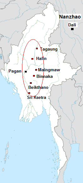
The Pyu city states were a group of city-states that existed from about the 2nd century BCE to the mid-11th century in present-day Upper Burma (Myanmar). The city-states were founded as part of the southward migration by the Tibeto-Burman-speaking Pyu people, the earliest inhabitants of Burma of whom records are extant. The thousand-year period, often referred to as the Pyu millennium, linked the Bronze Age to the beginning of the classical states period when the Pagan Kingdom emerged in the late 9th century.

Homalin or Hommalinn is a small town in north-western Burma and capital of the Homalin Township in Hkamti District of the Sagaing Region. The town lies on the Chindwin River and is served by Homalin Airport.

Singu is a township of Thabeikkyin District, Mandalay Division, Myanmar. The capital is Singu.
Lewe Township is one of eight townships of Naypyidaw Union Territory, Burma.

Myaungmya Township is a township of Myaungmya District in the Ayeyarwady Region of Myanmar. The principal town is Myaungmya.

Maubin Township, alternatively spelt Ma-ubin Township is a township of Maubin District in the Ayeyarwady Region of Myanmar. The Township borders Kyaiklat Township of Pyapon District to its south. Its western border is defined by the Irrawaddy River with Wakema Township of Myaungmya District to its west and Pantanaw Township to the northwest. Its north and northwest borders are within Maubin District with Nyaungdon Township completing the northeastern border. The township's eastern border follows the Khittaya-yaykyaw stream until it meets the Toe River, which it then follows. Yangon Region's Twantay Township borders it to the east bank of these water bodies. There are 12 urban wards and 76 village tracts totaling 442 villages in the township. The principal town of the township is Maubin.
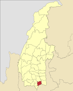
Myinmu is a river town in the south-east of the Sagaing Division in Burma. The town has a rich history linked to World War II during the Burma Campaign against the Japanese, in 1944. It was also under the control of the Portuguese Missionaries in the 19th century. One of the first agricultural cooperatives was established here in 1905.
Myaung is a town in the Sagaing Region in central Myanmar located on the west bank of the Ayeyarwady River. It is a region between the Rivers of Ayeyarwady and Chindwin. There are many ancient and histori၃မပ့အ၆၈၈ကက္ိမ့့ပျညလဘုအပျျုုညူးူူူငူု့ဘcal pagodas, monasteries, and places in Myaung Township. Myaung Township is officially demarcated with the neighbour boundaries of Chaung-U in the north-west, of Myinmu in the east and north east. In the township of Myaung, Kyauk Nagar Mountain is very famous, where very ancient rocky statues like the rocky dragon-shaped statues are found, and the Buddhist Region rich of many pagodas is situated. Myaung Township is one of the townships which were historically concerned with King Kyansit like Chaung-U Township. There are also many pagodas or Buddhist temples and monasteries of or built by King Kyansittha at the age of Bagan. It is a crowded town since it is located on the west bank of the river. To get there, there is Myaung-Payeinma Road, turning in from the Monywa-Mandalay one.

Myitnge River (Burmese: မြစ်ငယ် or Nam Tu, also known as Dokhtawaddy River, is a major tributary of Ayeyarwady River in Myanmar. The name Myitnge in Burmese and Dokhtawaddy in Pali both mean "little river", by contrast with the Ayeyarwady or "big river".

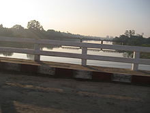
Mu River is a river in upper central Myanmar (Burma), and a tributary of the country's chief river, the Irrawaddy. It drains the Kabaw valley and part of the Dry Zone between the Ayeyarwady to the east and its largest tributary the Chindwin River to the west, flows directly north to south for about 275 km (171 mi) and enters the Ayeyarwady west of Sagaing near Myinmu.

Shwebo Township is a township of Shwebo District in the Myanmar's Sagaing Region. It is located on the plains between the Mu River and the Ayeyarwady River. The ancient palace of King Alaungmintaya is there. Its administrative seat is the city of Shwebo. As of 2014, it had a population of 266,807. 53.7% of its population was male while 46.3% was female.
Lingadipa is a village in Myinmu Township in the southeast of the Sagaing Division in Burma. It is located west of Myinmu, near Allagappa on the northern bank of the Irrawaddy River. The village was occupied by the British Indian Army on 13–14 February 1944 during World War II.
Kutkai is a town and seat of Kutkai Township, in the Shan State of eastern-central Burma. It lies along National Highway 3, approximately 24 kilometres to the north of Lashio.

Rice production in Myanmar accounts for approximately 43% of total agricultural production in the country, making it the seventh largest producer of rice in the world. Out of 67.6 million hectares of land, 12.8 million are used for cultivation. In 2019 alone, Myanmar accounted for 13,300 million metric tons of milled rice production.
The Tar Taing massacre was a mass killing of civilians by Burmese military forces between 1 and 2 March 2023, in the village of Tadaing, Sagaing Region, located 28 miles (45 km) west of Mandalay, Myanmar's 2nd largest city. During the massacre, Myanmar Army troops killed at least 17 civilians. The event has become one of Myanmar's deadliest civilian massacres in 2023. Just nine days after this massacre, military troops killed at least 28 additional individuals in the Pinlaung massacre.