
Sagaing Region is an administrative region of Myanmar, located in the north-western part of the country between latitude 21° 30' north and longitude 94° 97' east. It is bordered by India’s Nagaland, Manipur, and Arunachal Pradesh States to the north, Kachin State, Shan State, and Mandalay Region to the east, Mandalay Region and Magway Region to the south, with the Ayeyarwady River forming a greater part of its eastern and also southern boundary, and Chin State and India to the west. The region has an area of 93,527 km2. In 1996, it had a population of over 5,300,000 while its population in 2012 was 6,600,000. The urban population in 2012 was 1,230,000 and the rural population was 5,360,000. The capital city of Sagaing Region is Monywa.

Kyunhla is a town in Kanbalu District, Sagaing Division in north-western Burma (Myanmar) about 70 kilometres east of Mawlaik. It is the administrative center of Kyunhla Township.

Falam District is a district of the Chin State in Myanmar. It consists of 3 townships and 445 villages. The major towns include: Chikha (Gyikhar), Tonzang (Htonzan), Tiddim, Fort White, and Falam.
Falam Township is a township of Falam District in the Chin State of Burma (Myanmar). Its administrative seat is the town of Falam.
Paungbyin, also known as Pyaungbin or Phaungbyin, is a town in Mawlaik District, Sagaing Division, of Myanmar, on the Chindwin River. It is the principal town of Paungbyin Township.
Hkamti District or Khamti District is a district in northern Sagaing Division of Burma (Myanmar). Its administrative center is the town of Singkaling Hkamti.
Mawlaik District is a district in central Sagaing Division of Burma (Myanmar). Its administrative center is the town of Mawlaik.
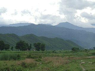
Kale District is the westernmost district in Sagaing Division of Myanmar (Burma).

Kalewa Township is a township of Kale District in Sagaing Division of Burma (Myanmar). The principal town and administrative seat is Kalewa. The Paluzawa coal mines are located in Kalewa township.
Kale Township is a township in Kale District in the Sagaing Division of Burma (Myanmar). The principal town is Kalay.
Paungbyin Township is a township in Mawlaik District in the Sagaing Division of Burma. The principal town is Paungbyin.
Natset is a major village on the Chindwin River in Paungbyin Township, Mawlaik District, in the Sagaing Region of northwestern Burma. It is located on the border of Homalin Township, southwest of Myene.
Kyigon is a village in Kale Township, Kale District, in the Sagaing Region of western Burma (Myanmar). Kyigon is located on the left (north) bank of the Myittha River about 2.4 kilometres (1.5 mi) above where the Neyinzaya River enters the Myittha. It is about 8.8 kilometres (5.5 mi) northeast of the regional capital at Kalemyo.
Mawlaik is a village in Kale Township, Kale District, in the Sagaing Region of western Burma.
Sittaung is a town in Paungbyin Township, Mawlaik District, in the Sagaing Region of Burma (Myanmar) on the right bank of the Chindwin River. There is a highway running west to the Indian border which provides Tamu with access to transport on the Chindwin. This road was laid out in 1887 by troops under Major General J. J. H. Gordon to better link Manipur with Upper Burma.
Yazagyo is the northernmost village in Kale Township, Kale District, of western Burma (Myanmar).
Neyinzaya River is a river in Chin State and Sagaing Region of Burma (Myanmar). It is a tributary of the Myittha River, enterring it from the left (west) just south of Kalemyo.
Siyin is a village in Kale Township, Kale District, in the Sagaing Region of western Burma. It is located about 10 kilometres (6.2 mi) west of Kalemyo on the Kalemyo – Theizang road. It lies at the mouth of the Siyin Valley where it debouches into the Kale Valley.
Zomi language is spoken mostly in Burma and India. In Chin State, it is spoken in Tedim and Tonzang townships, while in Sagaing Division, it is spoken in Kalay and Mawlaik townships (Ethnologue). Dialects are Sokte and Kamhau.
Tin Maung Win is a Burmese politician who currently serves as an Amyotha Hluttaw MP for Sagaing Region No. 10 constituency. He is a member of the National League for Democracy.


