The National Road was the first major improved highway in the United States built by the federal government. Built between 1811 and 1837, the 620-mile (1,000 km) road connected the Potomac and Ohio Rivers and was a main transport path to the West for thousands of settlers. When improved in the 1830s, it became the second U.S. road surfaced with the macadam process pioneered by Scotsman John Loudon McAdam.

The Shenandoah Valley is a geographic valley and cultural region of western Virginia and the Eastern Panhandle of West Virginia in the United States. The Valley is bounded to the east by the Blue Ridge Mountains, to the west by the eastern front of the Ridge-and-Valley Appalachians, to the north by the Potomac River, to the south by the James River, and to the Southwest by the New River Valley. The cultural region covers a larger area that includes all of the Valley plus the Virginia Highlands to the west and the Roanoke Valley to the south. It is physiographically located within the Ridge and Valley Province and is a portion of the Great Appalachian Valley.

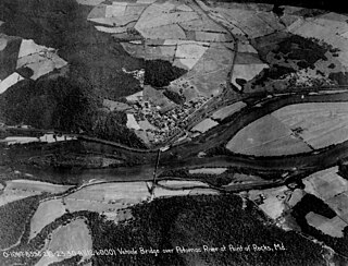
Point of Rocks is an unincorporated community and census-designated place (CDP) in Frederick County, Maryland. As of the 2010 census, it had a population of 1,466.

U.S. Route 522 is a spur route of US 22 in the states of Virginia, West Virginia, Maryland, and Pennsylvania. The U.S. Highway travels in a north-south direction, and runs 308.59 miles (496.63 km) from US 60 near Powhatan, Virginia, to its northern terminus at US 11 and US 15 near Selinsgrove, Pennsylvania. US 522 serves many small cities and towns in the Piedmont, Blue Ridge Mountains, and northern Shenandoah Valley of Virginia. The highway serves the Virginia communities of Goochland, Mineral, Culpeper, the town of Washington, and Front Royal and the independent city of Winchester. US 522 then follows the Ridge-and-Valley Appalachians north and then east through the Eastern Panhandle of West Virginia, a 2-mile-wide (3.2 km) stretch of Western Maryland, and South Central Pennsylvania to its terminus in the Susquehanna Valley. The highway serves Berkeley Springs, West Virginia; Hancock, Maryland; and the Pennsylvania communities of McConnellsburg, Mount Union, Lewistown, and Middleburg.

U.S. Route 340 is a spur route of US 40, and runs from Greenville, Virginia, to Frederick, Maryland. In Virginia, it runs north–south, parallel and east of US 11, from US 11 north of Greenville via Waynesboro, Grottoes, Elkton, Luray, Front Royal, and Berryville to the West Virginia state line. A short separate piece crosses northern Loudoun County on its way from West Virginia to Maryland.

Transportation in the Commonwealth of Virginia is by land, sea and air. Virginia's extensive network of highways and railroads were developed and built over a period almost 400 years, beginning almost immediately after the founding of Jamestown in 1607, and often incorporating old established trails of the Native Americans.

U.S. Route 50 is a transcontinental highway which stretches from Ocean City, Maryland to West Sacramento, California. In the U.S. state of Virginia, US 50 extends 86 miles (138 km) from the border with Washington, D.C. at a Potomac River crossing at Rosslyn in Arlington County to the West Virginia state line near Gore in Frederick County.

Difficult Run is a 15.9-mile-long (25.6 km) tributary stream of the Potomac River in Northern Virginia in the United States. The area has had many historical uses dating back to the early 1800s. Today, the area is used recreationally by visitors interested in the watershed's variety of options including hiking, biking, fishing, boating, climbing, and bird watching. The wildlife at Difficult Run is vast as 163 different species can be seen depending on the season. There are 41 different soil types found on the trail and alongside the stream. The stream is part of the greater 57.7- square-mile Drainage basin, or watershed, located in the north-central portion of Fairfax County and drains directly to the Potomac River.

The Metropolitan Subdivision is a railroad line owned and operated by CSX Transportation in the District of Columbia and the U.S. state of Maryland. The 53-mile line runs from Washington, D.C., northwest to Weverton, Maryland, along the former Metropolitan Branch of the Baltimore and Ohio Railroad.

The CSX Cumberland Subdivision is a railroad line owned and operated by CSX Transportation in the U.S. states of Maryland and West Virginia. The line runs from Brunswick, Maryland, west to Cumberland, Maryland, along the old Baltimore and Ohio Rail Road (B&O) main line. At its east end, the Cumberland Subdivision becomes the Metropolitan Subdivision; at its west end at Cumberland, Maryland it becomes the Cumberland Terminal Subdivision. It meets the Shenandoah Subdivision at Harpers Ferry, West Virginia, and the Lurgan Subdivision in Cherry Run, West Virginia.

Wills Mountain is a quartzite-capped ridge in the Ridge and Valley physiographic province of the Appalachian Mountains in Pennsylvania and Maryland, extending from near Bedford, Pennsylvania, to near Cumberland, Maryland. It is the northernmost of several mountain ridges included within the Wills Mountain Anticline.

Maryland Route 180 is a state highway in the U.S. state of Maryland. Known for most of its length as Jefferson Pike, the state highway runs 14.95 miles (24.06 km) from U.S. Route 340 in Knoxville east to Ballenger Creek Pike and Interstate 70 (I-70) in Frederick. MD 180 is the old alignment of US 340 through Knoxville, Petersville, and Jefferson in the Middletown Valley of western Frederick County. The state highway was originally constructed in the early 1910s and designated US 340 in 1927. MD 180 was assigned to the highway bypassed by the US 340 freeway between Sandy Hook in far southern Washington County and Jefferson in the mid-1960s. The state highway was extended east to Frederick and south along Ballenger Creek Pike after the US 340 freeway was completed in the late 1960s. MD 180 was rolled back to Frederick and removed from Washington County in 1989.

U.S. Route 40 in the U.S. state of Maryland runs from Garrett County in Western Maryland to Cecil County in the state's northeastern corner. With a total length of 221 miles (356 km), it is the longest numbered highway in Maryland. Almost half of the road overlaps or parallels with Interstate 68 (I-68) or I-70, while the old alignment is generally known as US 40 Alternate, US 40 Scenic, or Maryland Route 144. West of Baltimore, in the Piedmont and Appalachian Mountains / Blue Ridge region of the Western Maryland panhandle of the small state, the portions where it does not overlap an Interstate highway are mostly two-lane roads. The portion northeast of Baltimore going toward Wilmington in northern Delaware and Philadelphia in southeastern Pennsylvania is a four-lane divided highway, known as the Pulaski Highway. This section crosses the Susquehanna River at the north end of the Chesapeake Bay on the Thomas J. Hatem Memorial Bridge.

Maryland Route 67 is a state highway in the U.S. state of Maryland. Known as Rohrersville Road, the state highway runs 12.20 miles (19.63 km) from U.S. Route 340 in Weverton north to US 40 Alternate in Boonsboro. MD 67 parallels the western flank of South Mountain in southeastern Washington County, connecting Boonsboro with Weverton and Rohrersville. In conjunction with US 340 and US 40 Alternate, MD 67 connects Hagerstown and Harpers Ferry, West Virginia, a link that made the highway one of the original state roads marked for improvement in 1909. The first section of the state highway was constructed through Rohrersville around 1920. The remainder of the highway was built between Boonsboro and Weverton in the late 1920s and early 1930s. MD 67 was reconstructed with multiple relocations starting in the late 1950s, culminating in a relocation at the southern terminus to tie into the US 340 freeway in the late 1960s.

Elk Ridge, or Elk Mountain, is a mountain ridge of the Blue Ridge Mountains in Maryland and is the westernmost of four parallel ridges. It forms the western side of a narrow valley in which are situated the towns of Yarrowsburg and Brownsville. South Mountain is on the eastern side of this valley running roughly parallel to it. The ridge runs from Rohrersville, in the north, to the Potomac River across from Harpers Ferry, West Virginia, in the south. Across the Potomac the ridge continues as Blue Ridge Mountain in Virginia and West Virginia. To the west of Elk Mountain is the broader Cumberland Valley, in which lie the towns of Hagerstown and Chambersburg, and the Potomac River. The southern end of the ridge, which is part of Harpers Ferry National Historical Park, is known as Maryland Heights.

The Potomac Water Gap is a double water gap in the Blue Ridge Mountains, located at the intersection of the states of Virginia, West Virginia and Maryland, near Harpers Ferry. At 256 feet (78 m), it is the lowest crossing of the Blue Ridge Mountains.

Muddy Branch is a tributary stream of the Potomac River in Montgomery County, Maryland, United States, located about 14 miles (23 km) northwest of Washington, D.C.

Knoxville is an unincorporated community in Frederick and Washington counties, Maryland, United States. The Robert Clagett Farm and Magnolia Plantation are listed on the National Register of Historic Places.

The Appalachian region has always had to allocate much resources and time into transportation due to the region's notable and unique geography. Mountainous terrain and commonly occurring adverse weather effects such as heavy fog and snowfall made roads hazardous and taxing on the traveling vehicles. Initially, European settlers found gaps in the mountains, among them the Cumberland Gap and the Wilderness Road. Another notable challenge of Appalachian travel is the political elements of constructing transportation routes. Most travel systems are funded by municipalities, but since The Appalachian area has several different states it can be difficult for the various governments to agree on how to work on transportation. The most influential forms of travel in the Appalachian region are based on water trading routes, roads and railroads.


