
The Ashburnham Center Historic District is a historic district encompassing the core of the village center of Ashburnham, Massachusetts in the United States. It is a well-preserved industrial village that experienced its most significant period of growth in the mid-19th century. The district was added to the National Register of Historic Places in 1999.

Orange Center Historic District is a historic district encompassing the historic civic, commercial, and industrial heart of Orange, Massachusetts in the United States. It was listed on the National Register of Historic Places in 1989.
The Simsbury Center Historic District is a 75-acre (30 ha) historic district located in the town center area of Simsbury, Connecticut. It encompasses seven blocks of Hopmeadow Street, as well as the cluster of commercial, civic, and residential buildings along Railroad, Station, and Wilcox Streets, and Phelps Lane. Although its oldest element is the cemetery, most of its buildings were built in the late 19th and early 20th century. It was listed on the National Register of Historic Places in 1996.

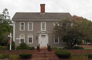
Westminster Village–Academy Hill Historic District encompasses the historic first town center of Westminster, Massachusetts, as well as its later early-19th century commercial core. Centered at the junction Main and South Streets with Academy Hill Road, it contains fine examples of Colonial, Federal, and Greek Revival architecture, including the 1839 town hall. The district was listed on the National Register of Historic Places in 1983.

The Central New Bedford Historic District is one of nine historic districts in New Bedford, Massachusetts, United States. The district encompasses the city's central business district, built up during the time in the late 19th century when textiles had replaced whaling as the city's main industry. It is a 29-acre (12 ha) rectangular area bounded by Acushnet Avenue and the older New Bedford Historic District on the east, School Street to the south, Middle Street on the north and 6th Street in the west. It was added to the National Register of Historic Places in 1980.

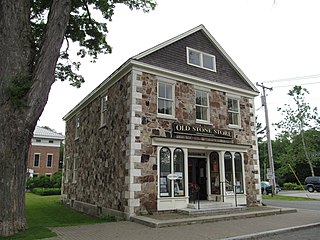
The Sutton Center Historic District is a historic district encompassing the center of the village of Sutton, Massachusetts. The district, which covers 435 acres (176 ha), is centered on the junction of Boston Road, Singletary Avenue, and Uxbridge Road. Boston Road is a major east-west route through the town, and the other two roads run north-south through the village center. A typically rural village center, its civic and institutional buildings are clustered near the intersection on its south side, in the general area of the town common. The town common and cemetery were laid out in 1719, after settlement of the township began in 1716. There are a few surviving houses that date to the middle of the 18th century or earlier; exact dates for most are uncertain. There are only a few institutional buildings: the 1829 Congregational Church, the 1983 Town Hall, built on the site of the town's first purpose-built town hall (1885), and Rufus Putnam Hall, an 1824 school building and Masonic lodge that now houses the local history museum. Only one commercial structure the 1839 Brick Block, stands in the village. There is also a historic animal pound, a rectangular stone structure used to pen stray livestock, which dates to the early days of the town.
The Central Square Historic District is a historic district encompassing an area in Weymouth, Massachusetts, which was historically significant in the pre-factory period of shoe manufacturing. It is centered at the intersection of Middle and Broad Streets, extending on Middle Street from Maple to Charles Streets, and on Broad from just west of the main junction to Putnam Street. Most of the houses built in this area between 1850 and 1870 were built for workers in relatively small shoemaking operations, one of which still stands at the main intersection. Later additions to the district include the Jefferson School, a Masonic temple, and the Clapp Memorial Building, which originally housed a boys' club.

The Town Hall Square Historic District is a historic district encompassing the center of Sandwich, Massachusetts. The original 54-acre (22 ha) district was visually centered on Sandwich Town Hall, Shawme Pond, and the reconstructed Dexter Grist Mill. When first listed on the National Register of Historic Places in 1975, it was roughly bounded by Main, Grove, Water Sts., and Tupper Rd. from Beale Ave. to MA 6A. In 2010 the district was expanded, adding another 170 acres (69 ha) and more than 150 contributing resources.
The Sheffield Center Historic District encompasses the historic village center of Sheffield, Massachusetts. The village extends linearly along United States Route 7, roughly between Maple Avenue and Berkshire School Road, and includes the town's major civic and religious buildings. The area's principal period of development was between 1760 and the 1890s. It was listed on the National Register of Historic Places in 1989.

The Upper Historic District is a historic district encompassing the historic center of Washington, Massachusetts. Centered on the junction of Washington Mountain Road and Branch Road, the town center flourished from the town's establishment in the 1750s until the center of the town's business moved closer to the newly lain railroad in the 1830s. The district includes the old town hall, cemetery, common, and pound, as well as a number of residences. A meeting house (church) and schoolhouse once stood in the area, but the 1792 church was destroyed by lightning in 1859, and the schoolhouse is no longer extant. The district was added to the National Register of Historic Places in 1987.

The Hatfield Center Historic District encompasses the traditional center of Hatfield, Massachusetts. The area, first laid out in 1661, is bounded by Maple Street to the south, the Connecticut River to the east, Day Avenue and School Street to the north, and the Mill River to the west. The area's layout and land use patterns are relatively little altered since they were laid out, leaving a well-preserved early colonial village landscape. The district was added to the National Register of Historic Places in 1994.

The Academy Historic District is a historic district in the center of Wilbraham, Massachusetts. Its 65 acres (26 ha) encompass the historic center of Wilbraham, as well as the historic central portion of the campus of the Wilbraham & Monson Academy. It includes properties on Mountain Road, Main Street, and Faculty Street. Wesleyan Academy was founded in 1817 and moved to Wilbraham in 1824; its oldest buildings date to 1825. It merged with Monson Academy in the 20th century to form the present school that occupies the academic premises. The academy was a major center of Methodist teaching in New England, and was a prominent factor in the town's growth.

The Granville Center Historic District is a historic district encompassing the historic center of Granville, Massachusetts. The cluster of buildings in the village center includes the Congregational church, and a number of Federal and Greek Revival residences. The district was listed on the National Register of Historic Places in 1991.

The Peabody Civic Center Historic District encompasses a well-preserved portion of the historic center of Peabody, Massachusetts. Extending along Chestnut and Franklin Streets south of Peabody City Hall, the district includes a small residential area built in the mid-19th century, as well as the city hall and St. JOhn the Baptist Roman Catholic Church, two monumental structures defining the town's civic heart. The district was added to the National Register of Historic Places in 1980.

The Bedford Center Historic District encompasses the historic heart of the town of Bedford, Massachusetts. It extends along Great Road between Bacon and Concord Roads, and includes primarily residential areas on adjacent side streets. The area includes the town's main civic buildings, its first cemetery, and a diverse array of residential architecture spanning more than two centuries. The district was listed on the National Register of Historic Places in 1977; its boundaries were adjusted in 2014 and its period of significance extended.

The Common Historic District is a historic district encompassing the civic and institutional heart of Reading, Massachusetts. The district is centered on the town common, at the intersection of Main and Salem Streets. The common has been communally owned since at least 1737, with the original burying ground to the north. In 1769 the area's first meeting house was built, giving the area a sense of identity separate from portions of Reading that would later be set off as Wakefield and North Reading. Since then the area has become a focal point for religious and civic institutions in the town.
The Arlington Center Historic District includes the civic and commercial heart of Arlington, Massachusetts. It runs along the town's main commercial district, Massachusetts Avenue, from Jason Street to Franklin Street, and includes adjacent 19th- and early 20th-century residential areas roughly bounded by Jason Street, Pleasant Street, and Gray Street. The district was listed on the National Register of Historic Places in 1974.

The Common District encompasses the main civic center of Wakefield, Massachusetts. It is centered on the historic town common, just south of Lake Quannapowitt, which was laid in 1644, when it became the heart of Old Reading. The area was separated from Reading as South Reading in 1818, and renamed Wakefield in 1868. The 25 acre district includes the buildings that line the common on Common Street and Main Street, which include the town hall, public library, YMCA, post office, and several churches. It was listed on the National Register of Historic Places in 1990.

The Town Center Historic District encompasses the historic village center of South Hampton, New Hampshire. Centered around the Barnard Green, the town common, on New Hampshire Route 107A, it includes architectural reminders of the town's growth and change over time. The district was listed on the National Register of Historic Places in 1983.

The Dunstable Center Historic District encompasses the town center of Dunstable, Massachusetts. Centered at the junction Main, High, and Pleasant Streets, this area has served as the town center since 1791, when its church was moved here. The district, now home to a broad array of residential and civic architecture, was listed on the National Register of Historic Places in 2002.


