Related Research Articles

Coventry is a town in Kent County, Rhode Island, United States. The population was 35,688 at the 2020 census and is part of the Pawtuxet River Valley.

North Smithfield is a town in Providence County, Rhode Island, United States, settled as a farming community in 1666 and incorporated into its present form in 1871. North Smithfield includes the historic villages of Forestdale, Primrose, Waterford, Branch Village, Union Village, Park Square, and Slatersville. The population was 12,588 at the 2020 census.

Northeastern Connecticut, better known as the Quiet Corner, is a historic region of the state of Connecticut, located in the northeastern corner of the state. It is generally associated with Windham County, but also sometimes incorporates eastern sections of Tolland County and the northern portion of New London County.
The Flat River is a river in the U.S. state of Rhode Island. It flows approximately 8.2 miles (13.2 km). There are no dams along the river's length.
Abbott Run is a de facto river in the U.S. state of Massachusetts and Rhode Island. It flows approximately 10 miles (16 km).
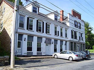
Forestdale is a village and historic district in North Smithfield, Providence County, Rhode Island, United States, one-half mile from Slatersville, Rhode Island. The historic district runs east and west along Main Street and north on Maple Avenue. School Street is the primary road through the village, and the one-room schoolhouse for which the street is named still stands. The Branch River runs through the valley adjacent to the School Street. The Village Haven Restaurant and local VFW chapter are also located in the village.

The Rice City Historic District is a historic district in Coventry, Rhode Island. It encompasses the 19th-century village of Rice City, extending along Plainfield Pike for several miles between Sisson Road and Gibson Hill Road in the northwestern part of Coventry. The main village center is at the junction of the Pike and Vaughn Hollow Road, and there is a former industrial and commercial center at Fairbank's Corner, the junction with Flat River Road. The architecture of the district is predominantly rural and residential, with Greek Revival and Federal style housing predominating. Rice City village is dominated by Rice Tavern, which used to serve travelers on their way to Connecticut, as well as the Rice City Church (1846), the Democrat Schoolhouse, and the Obadiah Potter House (1846), all a short way up Vaughn Hill Road. At the western edge of the district, the modern Pike alignment diverges from the historical one at Gibson Hill Road, where the foundational remnants of agricultural settlements may be found.

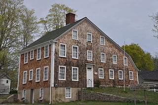
The Waterman Tavern is a historic house and tavern at 283 Maple Valley Road, near Whaley's Hollow in Coventry, Rhode Island. The 2+1⁄2-story wood-frame house was built before 1747 by John Waterman, who was licensed to operate a tavern on the premises in that year. It is five bays wide with a central chimney. The site was advantageously located on the main road between Providence and Plainfield, Connecticut. The tavern was a center of civic discourse, and town meetings were regularly held there until 1835.

The Tavern Hall Preservation Society is a not-for-profit corporation dedicated to the preservation and upkeep of the Elisha Reynolds House (1738) in Kingston, Rhode Island. The society was founded as the Tavern Hall Club in 1911 to foster understanding and cooperation between the people of the Village of Kingston and the nearby Rhode Island State College community.

Hopkins Hollow Village is an historic district along Hopkins Hollow Road, Narrow Lane, and Perry Hill Road in Coventry, Rhode Island, United States, and West Greenwich, Rhode Island.

Anthony is a village along Route 117 within the town of Coventry, Rhode Island near the villages of Washington and Quidnick on the southwestern banks of the Pawtuxet River. The village comprises "Anthony, Arnold, Boston, Mapledale, Meeting, Taft, Washington and Laurel Avenue."
Washington is a village within the town of Coventry in Kent County, Rhode Island, and is part of the Pawtuxet River Valley.

Harris is a village near the town of Coventry, Rhode Island on the north branch of the Pawtuxet River near West Warwick.

Quidnick is a village within the town of Coventry, Rhode Island.
Coventry Centre is a historic village in Coventry, Rhode Island.
Fairbanks is a village in the town of Coventry, Rhode Island on Route 14, Plainfield Pike, right after the village of Rice City and near the Connecticut border.

Arkwright is a village in the northeastern corner of Coventry, Rhode Island touching Cranston and Scituate, now connected by Route 115.
Spring Lake is a village in the town of Coventry, Rhode Island.
Tiogue is a village in Coventry, Rhode Island near the village of Washington.
Blackrock is a village in Kent County, Rhode Island, United States, located in the town of Coventry between the villages of Anthony and Arkwright.
References
- ↑ U.S. Geological Survey Geographic Names Information System: Whaley's Hollow, Rhode Island
- ↑ Andrew D. Boisvert, "Coventry Roots: Whaley's Hollow, Coventry Patch, September 22, 2011 http://coventry.patch.com/articles/coventry-roots-whaleys-hollow
Municipalities and communities of Kent County, Rhode Island, United States | ||
|---|---|---|
| City |  | |
| Towns | ||
| CDP | ||
| Villages | ||
41°43′08″N71°40′08″W / 41.719°N 71.669°W
| | This Rhode Island state location article is a stub. You can help Wikipedia by expanding it. |