The United States Fish and Wildlife Service is a U.S. federal government agency within the U.S. Department of the Interior which oversees the management of fish, wildlife, and natural habitats in the United States. The mission of the agency is "working with others to conserve, protect, and enhance fish, wildlife, plants and their habitats for the continuing benefit of the American people."

The Pearl River is a river in the U.S. states of Mississippi and Louisiana. It forms in Neshoba County, Mississippi from the confluence of Nanih Waiya and Tallahaga creeks, and has a meander length of 444 miles (715 km). The lower part of the river forms part of the boundary between Mississippi and Louisiana.

The whooping crane is an endangered crane species, native to North America, named for its “whooping” calls. Along with the sandhill crane, it is one of only two crane species native to North America, and it is also the tallest North American bird species. The whooping crane's lifespan is estimated to be 22-24 years in the wild. After being pushed to the brink of extinction, due to unregulated hunting and loss of habitat, and just 21 wild cranes remaining by 1941, conservation efforts would lead to a partial recovery. The total number of cranes in the surviving migratory population, plus three reintroduced flocks and in-captivity, only slightly exceeds 800 birds as of 2020.

The nutria or coypu is a large, herbivorous, semiaquatic rodent from South America. Classified for a long time as the only member of the family Myocastoridae, Myocastor is now included within Echimyidae, the family of the spiny rats. The nutria lives in burrows alongside stretches of water and feeds on river plant stems. Originally native to subtropical and temperate South America, it has since been introduced to North America, Europe and Asia, primarily by fur farmers. Although it is still hunted and trapped for its fur in some regions, its destructive burrowing and feeding habits often bring it into conflict with humans, and it is considered an invasive species in the United States. Nutria also transmit various diseases to humans and animals, mainly through water contamination.

Kisatchie National Forest, the only National forest in Louisiana, United States, is located in the forested piney hills and hardwood bottoms of seven central and northern parishes. It is part of the Cenozoic uplands and has large areas of longleaf pine forests. It is one of the largest pieces of natural landscape in Louisiana, with some 604,000 acres (2,440 km2) of public land, more than half of which is vital longleaf pine and flatwoods vegetation. These support many rare plant and animal species. There are also rare habitats, such as hillside seepage bogs and calcareous prairies. The forest also contains and provides a buffer for the Kisatchie Hills Wilderness, a nationally designated wilderness area that contributes to protecting biodiversity of the coastal plain region of the United States.

The Mississippi River Delta is the confluence of the Mississippi River with the Gulf of Mexico in Louisiana, southeastern United States. The river delta is a three-million-acre area of land that stretches from Vermilion Bay on the west, to the Chandeleur Islands in the east, on Louisiana's southeastern coast. It is part of the Gulf of Mexico and the Louisiana coastal plain, one of the largest areas of coastal wetlands in the United States. The Mississippi River Delta is the 7th largest river delta on Earth (USGS) and is an important coastal region for the United States, containing more than 2.7 million acres of coastal wetlands and 37% of the estuarine marsh in the conterminous U.S. The coastal area is the nation's largest drainage basin and drains about 41% of the contiguous United States into the Gulf of Mexico at an average rate of 470,000 cubic feet per second.
Cameron Prairie National Wildlife Refuge is located approximately 25 miles (40 km) southeast of Lake Charles, Louisiana, in north central Cameron Parish. It contains 9,621 acres (3,893 ha) that include fresh marsh, coastal prairie, and old rice fields.

Catahoula Lake is a large freshwater lake located in LaSalle Parish and Rapides Parish of central Louisiana, United States.
The North American Wetlands Conservation Act signed into law by President George H. W. Bush on December 13, 1989 authorizes a wetlands habitat program, administered by the United States Fish and Wildlife Service, which provides grants to protect and manage wetland habitats for migratory birds and other wetland wildlife in the United States, Mexico, and Canada. A nine-member council meets periodically to decide which projects to fund.
Pass a Loutre Wildlife Management Area (WMA) is a 115,000-acre (47,000 ha) protected wetland in Plaquemines Parish, Louisiana, United States. The WMA is located due south and bordering the 48,000 acre Delta National Wildlife Refuge, accessible only by air or boat, contains the Pass A L'Outre Lighthouse, and Port Eads is within the boundary.
The Louisiana Department of Wildlife and Fisheries (LDWF) is a state agency of Louisiana that maintains state wildlife and fishery areas. The agency is headquartered in the capital city of Baton Rouge.
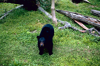
The Louisiana black bear, one of 16 subspecies of the American black bear, is found in parts of Louisiana, mainly along the Mississippi River Valley and the Atchafalaya River Basin. It was classified as 'threatened' under the U.S. Endangered Species Act from 1992–2016. The validity of this subspecies has been repeatedly debated.
The Sherburne Complex is a joint land management venture of the U.S. Fish and Wildlife Service, the Louisiana Department of Wildlife and Fisheries (LDWF), and the U.S. Army Corps of Engineers that began in 1983. The area consists of 43,637 acres (17,659 ha), and is managed by the Louisiana Department of Wildlife and Fisheries. The complex is located in the Morganza Flood way system of the Atchafalaya Basin about 30 miles (48 km) west of Baton Rouge, Louisiana and actually extends a little south of the I-10 Atchafalaya Basin Bridge at Whiskey Bay, Louisiana. The bridge crosses the Whiskey Bay Pilot Channel. Located on the graveled LA 975, the west boundary is on the east side of the Atchafalaya River with the east boundary being the East Protection Levee. The complex stretches just north of old highway 190, and a short distance to the south of I-10. The nearest town is Krotz Springs to the north off US 190.

The Rockefeller Wildlife Refuge is a large area of marshland in Cameron Parish and Vermilion Parish, Louisiana, United States. It was donated to the state with certain provisions as to its management as a wildlife sanctuary. It is a biodiverse habitat and is visited annually by many migratory birds. Much research is undertaken into marshland management and alligator ranching, and the income from the sale of alligators contributes to conservation of the marshland.

Short Hills Wildlife Management Area is a 4,232-acre (17.13 km2) Wildlife Management Area (WMA) located in Rockbridge and Botetourt counties, Virginia. It covers approximately 10 miles (16 km) of ridgeline along the Short Hills range.
Elm Hall Wildlife Management Area is a 2,839-acre (1,149 ha) protected area in Assumption Parish, Louisiana. The WMA is located five miles west of Napoleonville, with Lake Verret on the western border, farmland to the east, and is managed by the Louisiana Department of Wildlife and Fisheries (LDWF).
Clear Creek Wildlife Management Area is a 52,559-acre (21,270 ha) tract of protected area located in Vernon Parish, Louisiana. The Louisiana Department of Wildlife and Fisheries (LDWF) leases the land from Hancock Timber.
Maurepas Swamp Wildlife Management Area is a 112,615-acre (45,574 ha) tract of protected area located in parts of Ascension, Livingston, St. John the Baptist, St. James and Tangipahoa Parishes, Louisiana encircling three sides of Lake Maurepas.

The Derelict Crab Trap Removal Program was created by the Louisiana Wildlife and Fisheries Commission in 2004. This was created to remove derelict crab traps from state-owned lakes and river-beds and to reduce the potential impact from these traps. This program also collects data from all of the different animals that were found in the traps. It takes place in different areas of Louisiana usually between late February and early March.
Joyce Wildlife Management Area is a 42,292 acres (17,115 ha) protected area in Tangipahoa Parish, Louisiana, owned by the Louisiana Department of Wildlife and Fisheries. It is located 10 miles (16 km) south of Hammond and features a boardwalk leading into the swamps on the northwest corner.