
Lancaster County is a county located in the U.S. state of South Carolina. As of the 2010 census, its population was 76,652. Its county seat is Lancaster, which has an urban population of 23,979. The county was created in 1785.

Okmulgee County is a county in the U.S. state of Oklahoma. As of the 2010 census, the population was 40,069. The county seat is Okmulgee. Formerly part of the Creek Nation, the county was created at statehood in 1907. The name Okmulgee is derived from the Hitichita word okimulgi, meaning "boiling waters".

Holt County is a county in the U.S. state of Nebraska. As of the 2010 United States Census, the population was 10,435. Its county seat is O'Neill.

Jones County is a county in the central portion of the U.S. state of Georgia. As of the 2010 census, the population was 28,669. The county seat is Gray. The county was created on December 10, 1807, and named after U.S. Representative James Jones.

Abilene is a city in and the county seat of Dickinson County, Kansas, United States. As of the 2020 census, the population of the city was 6,460. It is home of The Dwight D. Eisenhower Presidential Library and Museum and the Greyhound Hall of Fame.

Lincoln Center, more commonly known as Lincoln, is a city in and the county seat of Lincoln County, Kansas, United States. As of the 2010 census, the city population was 1,297.

Salina is a city in and the county seat of Saline County, Kansas, United States. As of the 2020 census, the population of the city was 46,889. It is a regional trade center for north-central Kansas, within one of the world's largest wheat-producing areas. It is home to multiple colleges.

Pond Creek is a city in Grant County, Oklahoma, United States, along the Salt Fork Arkansas River. As of the 2010 census, the city population was 856, a 4.5 percent decline from the figure of 896 in 2000.

Manhattan is a city and county seat of Riley County, Kansas, United States, although the city extends into Pottawatomie County. It is located in northeastern Kansas at the junction of the Kansas River and Big Blue River. As of the 2020 census, the population of the city was 54,100. The city was founded by settlers from the New England Emigrant Aid Company as a Free-State town in the 1850s, during the Bleeding Kansas era. Nicknamed "The Little Apple" as a play on New York City's "Big Apple", Manhattan is best known as the home of Kansas State University and has a distinct college town atmosphere. Fort Riley, a United States Army post, is located 8 miles (13 km) west of Manhattan.

The Chattahoochee River forms the southern half of the Alabama and Georgia border, as well as a portion of the Florida - Georgia border. It is a tributary of the Apalachicola River, a relatively short river formed by the confluence of the Chattahoochee and Flint rivers and emptying from Florida into Apalachicola Bay in the Gulf of Mexico. The Chattahoochee River is about 430 miles (690 km) long. The Chattahoochee, Flint, and Apalachicola rivers together make up the Apalachicola–Chattahoochee–Flint River Basin. The Chattahoochee makes up the largest part of the ACF's drainage basin.
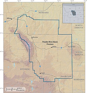
The Powder River Basin is a geologic structural basin in southeast Montana and northeast Wyoming, about 120 miles (190 km) east to west and 200 miles (320 km) north to south, known for its extensive coal reserves. The former hunting grounds of the Oglala Lakota, the area is very sparsely populated and is known for its rolling grasslands and semiarid climate.

The Cimarron River extends 698 miles (1,123 km) across New Mexico, Oklahoma, Colorado, and Kansas. The headwaters flow from Johnson Mesa west of Folsom in northeastern New Mexico. Much of the river's length lies in Oklahoma, where it either borders or passes through eleven counties. There are no major cities along its route. The river enters the Oklahoma Panhandle near Kenton, Oklahoma, crosses the southeastern corner of Colorado into Kansas, reenters the Oklahoma Panhandle, reenters Kansas, and finally returns to Oklahoma where it joins the Arkansas River at Keystone Reservoir west of Tulsa, Oklahoma, its only impoundment. The Cimarron drains a basin that encompasses about 18,927 square miles (49,020 km2).

Tuttle Creek Lake is a reservoir on the Big Blue River 5 miles (8 km) north of Manhattan, in the Flint Hills region of northeast Kansas. It was built and is operated by the Army Corps of Engineers for the primary purpose of flood control. Secondary functions of the project include release of water stores to maintain barge traffic on the Mississippi River during seasons of drought, maintenance of a multi-use conservation pool for fish and wildlife enhancement and recreation, and release of sufficient water in droughts to maintain water quality for downstream communities.
K-99 is a state highway in the U.S. state of Kansas. The highway runs 234.473 miles (377.348 km) from Oklahoma State Highway 99 (SH-99) at the Oklahoma state line near Chautauqua north to Nebraska Highway 99 (N-99) at the Nebraska state line in Summerfield. K-99 connects Emporia with several smaller county seats to the south and north, including Sedan, Howard, Eureka, Alma, and Westmoreland while passing through the Flint Hills of eastern Kansas.
The Department of the Missouri was a command echelon of the United States Army in the 19th century and a sub division of the Military Division of the Missouri that functioned through the Indian Wars.

Kansas City 33 School District, operating as Kansas City Public Schools or KCPS, is a school district headquartered at 2901 Troost Avenue in Kansas City, Missouri, United States.
The Overland Trail was a stagecoach and wagon trail in the American West during the 19th century. While portions of the route had been used by explorers and trappers since the 1820s, the Overland Trail was most heavily used in the 1860s as a route alternative to the Oregon, California, and Mormon trails through central Wyoming. The Overland Trail was famously used by the Overland Stage Company owned by Ben Holladay to run mail and passengers to Salt Lake City, Utah, via stagecoaches in the early 1860s. Starting from Atchison, Kansas, the trail descended into Colorado before looping back up to southern Wyoming and rejoining the Oregon Trail at Fort Bridger. The stage line operated until 1869 when the completion of the First Transcontinental Railroad eliminated the need for mail service via stagecoach.

Lovewell Reservoir is a reservoir in Jewell County, Kansas, United States. Built and managed by the U.S. Bureau of Reclamation, it is used for flood control, irrigation, and recreation. Lovewell State Park is located on its north shore.
K-128 is a 36.9-mile-long (59.4 km) north–south state highway in the U.S. state of Kansas. K-128's southern terminus is at U.S. Route 24 (US-24) and K-9 northwest of Glen Elder, and the northern terminus continues as Nebraska Highway 78 (N-78) at the Nebraska border north of Burr Oak. West of Mankato, a small section of K-128 is co-designated as US-36.
