
The Southside is the part of Dublin city that lies south of the River Liffey. It is an informal but commonly used term. In comparison to the city's Northside, it has historically been regarded as wealthier and more privileged, with several notable exceptions.
Rathfarnham is a Southside suburb of Dublin, Ireland. It is south of Terenure, east of Templeogue, and is in the postal districts of Dublin 14 and 16. It is within the administrative areas of both Dún Laoghaire–Rathdown County Council and South Dublin County Council.
Harold's Cross is an affluent urban village and inner suburb on the south side of Dublin, Ireland in the postal district D6W. The River Poddle runs through it, though largely in an underground culvert, and it holds a major cemetery, Mount Jerome, and Our Lady's Hospice.

Templeogue is a southwestern suburb of Dublin in Ireland. It lies between the River Poddle and River Dodder, and is about halfway from Dublin's centre to the mountains to the south.
Terenure, originally called Roundtown, is an affluent, middle class suburb of Dublin in Ireland. It is located in the city's D6W postcode area.

Knocklyon is a suburb of Dublin in county of South Dublin, within the old County Dublin, Ireland. Unlike many Dublin suburbs, Knocklyon was not developed around a village; rather it largely comprises modern housing built between the village of Templeogue and the former hamlet, now a suburb in its own right, of Firhouse. A number of old cottages and farmhouses along the Knocklyon Road attest to the area's rural past.

Coolock is a large suburban area, centred on a village, on Dublin city's Northside in Ireland. Coolock is crossed by the Santry River, a prominent feature in the middle of the district, with a linear park and ponds. The Coolock suburban area encompasses parts of three Dublin postal districts: Dublin 5, Dublin 13 and Dublin 17.

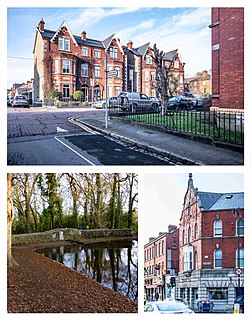
Rathgar, is a suburb of Dublin in Ireland. It was originally a village which from 1862 was part of the township of Rathmines and Rathgar; it was absorbed by the growing city and became a suburb in 1930. It lies about three kilometres south of the city centre.

Dublin South was a parliamentary constituency represented in Dáil Éireann, the lower house of the Irish parliament or Oireachtas, from 1981 to 2016 representing an area in the south of County Dublin. The method of election was proportional representation by means of the single transferable vote (PR-STV).
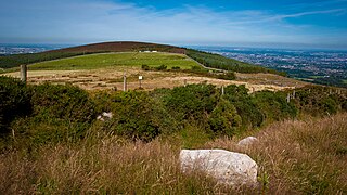
Kilmashogue or Kilmashoge is a mountain in Dún Laoghaire–Rathdown county in Ireland. It is 408 metres high and forms part of the group of hills in the Dublin Mountains which comprises Two Rock, Three Rock, Kilmashogue and Tibradden Mountains. The forest plantation on its northern slope, which is composed mainly of Sitka spruce, Scots pine and beech, is a habitat for Sika deer, hares, rabbits and foxes. A number of prehistoric monuments can be found on the slopes of the mountain.
Ballyroan is a suburban area within Rathfarnham, County Dublin, Ireland. It lies at the foot of the Dublin mountains, alongside Ballyboden, Butterfield, Knocklyon, Old Orchard, and Scholarstown. The townland of Ballyroan crosses civil parish and barony boundaries with roughly 114 acres of the historical townland in the civil parish of Tallaght in the barony of Uppercross, and nearly 10 acres in the civil parish of Rathfarnham in the barony of Rathdown. The modern suburb of Ballyroan has extended somewhat beyond the traditional townland boundaries.

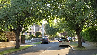
Ballyboden is a locality within the suburb of Rathfarnham in South Dublin, at the foot of the Dublin Mountains between Whitechurch, Ballyroan and Knocklyon. It is a townland in the civil parish of Rathfarnham in the Barony of Uppercross.

Firhouse is an outer suburb of Dublin, in the county of South Dublin, in the south of the traditional County Dublin, Ireland. It developed from a rural village by the River Dodder, with a second settlement, Upper Fir-house, nearby. It is just outside the M50 orbital motorway, and in the postal district of Dublin 24. It is adjacent to Knocklyon and Ballycullen, and close to Tallaght. In the historic divisions of local administration, Firhouse is in the civil parish of Tallaght and the barony of Uppercross.
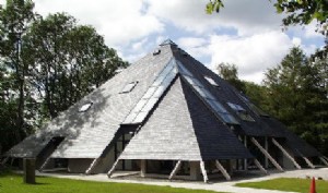
Larch Hill International Scout and Guide Centre is the national campsite, and administrative and training headquarters of Scouting Ireland. It was previously owned by Scouting Ireland (CSI).

Tibradden Mountain is a mountain in County Dublin in Ireland. Other former names for the mountain include "Garrycastle" and "Kilmainham Begg". It is 467 metres high and is the 561st highest mountain in Ireland. It forms part of the group of hills in the Dublin Mountains which comprises Two Rock, Three Rock, Kilmashogue and Tibradden Mountains. The views from the summit encompass Dublin to the north, Two Rock to the east and the Wicklow Mountains to the south and west. The geological composition is mainly granite and the southern slopes are strewn with granite boulders. The summit area is a habitat for heather, furze, gorse and bilberry as well as Sika deer, foxes and badgers. The forestry plantation on the slopes – known as the Pine Forest – contains Scots pine, Japanese larch, European larch, Sitka spruce, oak and beech. The mountain is also a site of archaeological interest with a prehistoric burial site close to the summit.
Whitechurch is a townland, monastic site, and former parish situated between Straffan and Kill county Kildare near the M7 motorway in Ireland.
Wanderers are a Gaelic Athletic Association club located in Ballyboden, Dublin, Ireland.

The Naul Hills, or Man-of-War Hills are low-lying hills in north County Dublin, Ireland, close to the village of Naul, formerly called The Naul,. They lie beside the County Meath border, 30 kilometres north of Dublin City, 16 km north-northwest of Swords, and 8 km southwest of Balbriggan.
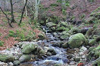
The Owendoher River is a small river in southern County Dublin, Ireland, the largest tributary of the River Dodder, and a part of the River Liffey system.
Cruagh is a civil parish in the barony of Uppercross in South Dublin, Ireland. It contains the townlands of Cruagh, Killakee, Tibradden, Glendoo, Newtown, Jamestown, Woodtown and Orlagh. It is situated south of Ballyboden on the R116 regional road.

