Related Research Articles

Nodaway County is a county located in the northwest part of Missouri. As of the 2010 census, the population was 23,370. Its county seat is Maryville. The county was organized February 14, 1845, and is named for the Nodaway River. It is the largest in area of the counties added to Missouri in the 1836 Platte Purchase, and the fourth-largest county in Missouri.

Hickory County is a county located in the U.S. state of Missouri. As of the 2010 census, the population was 9,627. Its county seat is Hermitage. The county was organized February 14, 1845, and named after President Andrew Jackson, whose nickname was "Old Hickory." The Pomme de Terre Dam, a Corps of Engineers facility, is located three miles south of Hermitage and forms Lake Pomme de Terre by damming the Pomme de Terre River and Lindley Creek. The county is also home to Lucas Oil Speedway at Wheatland that includes a major circle dirt racing track, an off-road racing track as well as a large man-made water drag racing facility. Truman Reservoir, also a Corps of Engineers facility, floods the Pomme de Terre Reservoir from the northern border of the county southward to the city limits of Hermitage.
Hermitage is a city in Hickory County, Missouri, United States, on the Pomme de Terre River. The population was 467 at the 2010 census. It is the county seat of Hickory County. The John Siddles Williams House on Museum Street in Hermitage, on the National Register of Historic Places since 1980, houses the Hickory County Historical Society Museum and Research Room.
Arkoe is a village in Nodaway County, Missouri, United States. The population was 68 at the 2010 census.

Maryville is a city and county seat of Nodaway County, Missouri, United States. As of the 2010 census, the city population was 11,972. Maryville is home to Northwest Missouri State University, Northwest Technical School, and the former home of the Missouri Academy of Science, Mathematics and Computing. Maryville is the second largest city wholly within the boundaries of the 1836 Platte Purchase which expanded Missouri's borders into former Indian Territory in northwest Missouri.
White Cloud may refer to:
Xenia is an extinct community in Nodaway County, Missouri, in the United States. The exact location of Xenia is unknown to the GNIS.
White Cloud is an unincorporated community in Hickory County, in the U.S. state of Missouri. It is north-northwest of Hermitage, Missouri, the county seat.
Allison is an unincorporated community in Nodaway County, in the U.S. state of Missouri.
Bedison is an unincorporated community in Nodaway County, in the U.S. state of Missouri.
Bell Grove is an unincorporated community in Nodaway County, in the U.S. state of Missouri.
Gaynor is an unincorporated community in Nodaway County, in the U.S. state of Missouri.
Orrsburg is an unincorporated community in Nodaway County, in the U.S. state of Missouri.
White Cloud Creek is a stream in Andrew and Nodaway Counties in the U.S. state of Missouri. It is a tributary of One Hundred and Two River.
Wilcox is an unincorporated community in Nodaway County, in the U.S. state of Missouri.
Hopkins Township is a township in Nodaway County, in the U.S. state of Missouri.
Jefferson Township is a township in Nodaway County, in the U.S. state of Missouri.
White Cloud Township is a township in Nodaway County, in the U.S. state of Missouri.
Pumpkin Center is located in Grant Township, Dallas County, Missouri. It is in the Missouri Ozarks at an elevation of 1,130 feet, near the intersection of Missouri Route 64 and Missouri Route 73 off Pumpkin Center Drive. It is approximately 7 miles north-northeast of Buffalo, Missouri, the Dallas County seat, and about 26 miles west-northwest of Lebanon, Missouri.
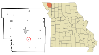
Pumpkin Center is located in White Cloud Township, Nodaway County, Missouri at an elevation of 1,020 feet, approximately 10 miles south of the Nodaway County seat of Maryville, Missouri on US Route 71.
References
- ↑ U.S. Geological Survey Geographic Names Information System: Whitecloud, Nodaway County, Missouri
- ↑ "Maryville, Missouri to Whitecloud, Missouri". Google Maps. Retrieved June 22, 2021.
- ↑ "Hermitage, Missouri to White Cloud, Missouri". Google Maps. Retrieved June 22, 2021.
- ↑ "Post Offices". Jim Forte Postal History. Retrieved 24 November 2016.
- ↑ "Nodaway County Place Names, 1928–1945". The State Historical Society of Missouri. Archived from the original on June 24, 2016. Retrieved November 24, 2016.
Municipalities and communities of Nodaway County, Missouri, United States | ||
|---|---|---|
| Cities |  | |
| Villages | ||
| Townships | ||
| CDPs | ||
| Other communities | ||
| Ghost town | ||
Coordinates: 40°12′32″N94°53′48″W / 40.20889°N 94.89667°W
| | This Nodaway County, Missouri state location article is a stub. You can help Wikipedia by expanding it. |