Hermitage, Missouri

Last updated
Hermitage, Missouri
Hickory County Missouri Courthouse 20191026-6904.jpg
Hickory County Courthouse in Hermitage
Hickory County Missouri Incorporated and Unincorporated areas Hermitage Highlighted.svg
Location of Hermitage, Missouri
Coordinates: 37°56′40″N93°19′33″W / 37.94444°N 93.32583°W / 37.94444; -93.32583 Coordinates: 37°56′40″N93°19′33″W / 37.94444°N 93.32583°W / 37.94444; -93.32583
Country United States
State Missouri
County Hickory
Area
[1]
  Total1.32 sq mi (3.42 km2)
  Land1.30 sq mi (3.36 km2)
  Water0.02 sq mi (0.06 km2)
Elevation
[2]
850 ft (260 m)
Population
 (2020)
  Total621
  Density478.80/sq mi (184.93/km2)
Time zone UTC-6 (Central (CST))
  Summer (DST) UTC-5 (CDT)
ZIP code
65668
Area code 417
FIPS code 29-31780 [3]
GNIS feature ID2394362 [2]

Hermitage is a city in Hickory County, Missouri, United States, on the Pomme de Terre River. The population was 621 at the 2020 census. [4] It is the county seat of Hickory County. [5] The John Siddles Williams House on Museum Street in Hermitage, on the National Register of Historic Places since 1980, houses the Hickory County Historical Society Museum and Research Room. [6]

Contents

History

Hermitage was founded in 1846. It was named after The Hermitage, [7] the estate of the late president Andrew Jackson in Tennessee. [8] In 1847, it was designated seat of Hickory County, also named for Andrew Jackson, whose nickname was "Old Hickory". [9] [10]

John Siddle Williams House was listed on the National Register of Historic Places in 1980. [11]

Geography

Hermitage is located at 37°56′31″N93°19′4″W / 37.94194°N 93.31778°W / 37.94194; -93.31778 (37.941816, -93.317901). [12] According to the United States Census Bureau, the city has a total area of 1.25 square miles (3.24 km2), all land. [13]

Demographics

Historical population
CensusPop.Note
1880 167
1950 204
1960 32860.8%
1970 284−13.4%
1980 38435.2%
1990 51233.3%
2000 406−20.7%
2010 46715.0%
2020 62133.0%
U.S. Decennial Census [14]

2010 census

As of the census [15] of 2010, there were 467 people, 200 households, and 106 families living in the city. The population density was 373.6 inhabitants per square mile (144.2/km2). There were 237 housing units at an average density of 189.6 per square mile (73.2/km2). The racial makeup of the city was 96.6% White, 0.4% African American, 0.4% Native American, 0.4% from other races, and 2.1% from two or more races. Hispanic or Latino of any race were 0.6% of the population.

There were 200 households, of which 16.5% had children under the age of 18 living with them, 43.5% were married couples living together, 6.0% had a female householder with no husband present, 3.5% had a male householder with no wife present, and 47.0% were non-families. 40.0% of all households were made up of individuals, and 22.5% had someone living alone who was 65 years of age or older. The average household size was 2.01 and the average family size was 2.65.

The median age in the city was 60.3 years. 12.8% of residents were under the age of 18; 4.7% were between the ages of 18 and 24; 15.9% were from 25 to 44; 25.5% were from 45 to 64; and 41.1% were 65 years of age or older. The gender makeup of the city was 46.0% male and 54.0% female.

2000 census

At the 2000 census, [3] there were 406 people, 174 households and 108 families living in the city. The population density was 337.9 inhabitants per square mile (130.5/km2). There were 208 housing units at an average density of 173.1 per square mile (66.8/km2). The racial makeup of the city was 93.60% White, 0.25% Native American, 1.23% from other races, and 4.93% from two or more races. Hispanic or Latino of any race were 1.23% of the population.

There were 174 households, of which 26.4% had children under the age of 18 living with them, 50.0% were married couples living together, 7.5% had a female householder with no husband present, and 37.4% were non-families. 35.1% of all households were made up of individuals, and 21.3% had someone living alone who was 65 years of age or older. The average household size was 2.29 and the average family size was 2.94.

Age distribution was 23.6% under the age of 18, 6.9% from 18 to 24, 22.7% from 25 to 44, 21.2% from 45 to 64, and 25.6% who were 65 years of age or older. The median age was 43 years. For every 100 females, there were 98.0 males. For every 100 females age 18 and over, there were 86.7 males.

The median household income was $23,958, and the median family income was $29,583. Males had a median income of $20,417 versus $18,958 for females. The per capita income for the city was $12,944. About 13.2% of families and 18.6% of the population were below the poverty line, including 25.0% of those under age 18 and 15.2% of those age 65 or over.

Education

Public education in Hermitage is administered by Hermitage R-IV School District, which operates one elementary school, one middle school and Hermitage High School. [16]

Hermitage has a lending library, the Hickory County Library. [17]

Related Research Articles

<span class="mw-page-title-main">St. Clair County, Missouri</span> County in Missouri, United States

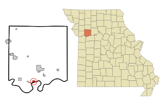
St. Clair County is a county located in the western portion of the U.S. state of Missouri. As of the 2020 census, the population was 9,284. Its county seat is Osceola. The largest city is Appleton City. The county was organized in 1841 and named after General Arthur St. Clair, Governor of the Northwest Territory. St. Clair was also the 9th president of the United States in Congress Assembled. Under his presidency, the Northwest Ordinance and United States Constitution were passed.

<span class="mw-page-title-main">Polk County, Missouri</span> County in Missouri, United States

Polk County is a county located in the southwestern portion of the U.S. state of Missouri. As of the 2010 census, the population was 31,137. Its county seat is Bolivar. The county was organized January 5, 1835, and named for Ezekiel Polk.

<span class="mw-page-title-main">Hickory County, Missouri</span> County in Missouri, United States

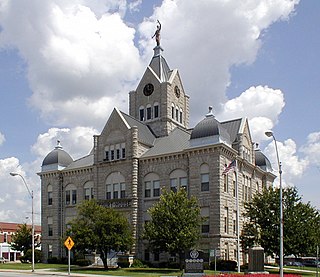
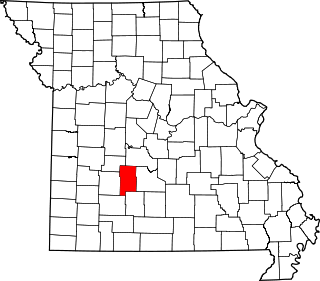
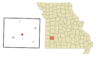
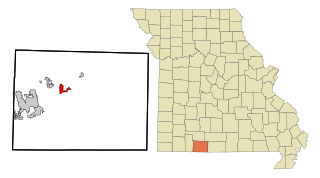
Hickory County is located in the U.S. state of Missouri. As of the 2020 census, the population was 8,279. Its county seat is Hermitage. The county was organized February 14, 1845, and named after President Andrew Jackson, whose nickname was "Old Hickory." The Pomme de Terre Dam, a Corps of Engineers facility, is located three miles south of Hermitage and forms Lake Pomme de Terre by damming the Pomme de Terre River and Lindley Creek. Truman Reservoir, also a Corps of Engineers facility, floods the Pomme de Terre Reservoir from the northern border of the county southward to the city limits of Hermitage.

<span class="mw-page-title-main">Dallas County, Missouri</span> County in Missouri, United States

Dallas County is a county located in the U.S. state of Missouri. As of the 2010 census, the population was 16,777. Its county seat is Buffalo. The county was organized in 1842 as Niangua County and then renamed in 1844 for George M. Dallas, who served as Vice President under James K. Polk.

<span class="mw-page-title-main">Tonalea, Arizona</span> CDP in Coconino County, Arizona

Tonalea is a census-designated place (CDP) in Coconino County, Arizona, United States. The population was 549 at the 2010 census. It has also been known as Red Lake.

<span class="mw-page-title-main">Havana, Kansas</span> City in Montgomery County, Kansas

Havana is a city in Montgomery County, Kansas, United States. As of the 2020 census, the population of the city was 84.

<span class="mw-page-title-main">Bliss Corner, Massachusetts</span> Census-designated place in Massachusetts, United States

Bliss Corner is a census-designated place (CDP) in the town of Dartmouth in Bristol County, Massachusetts, United States. The population was 5,280 at the 2010 census.

<span class="mw-page-title-main">Delta, Missouri</span> City in Missouri, United States

Delta is a city in Cape Girardeau County, Missouri, United States. The population was 376 at the 2020 census. It is part of the Cape Girardeau–Jackson, MO-IL Metropolitan Statistical Area.

<span class="mw-page-title-main">Pilot Grove, Missouri</span> City in Missouri, United States

Pilot Grove is a city in the Pilot Grove Township in northern Cooper County, Missouri, United States. The population was 768 at the 2010 census.

<span class="mw-page-title-main">Greenfield, Missouri</span> City in Missouri, United States

Greenfield is a city in Dade County, Missouri. The population was 1,220 at the 2020 census. It is the county seat of Dade County.

<span class="mw-page-title-main">Cross Timbers, Missouri</span> City in Missouri, United States

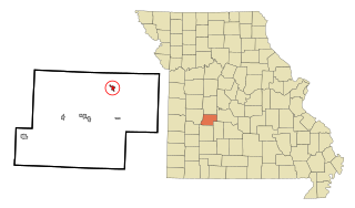
Cross Timbers is a city in Hickory County, Missouri, United States. The population was 119 at the 2020 census.

<span class="mw-page-title-main">Preston, Missouri</span> Village in Missouri, United States

Preston is a village in Hickory County, Missouri, United States. The population was 157 at the 2020 census.

<span class="mw-page-title-main">Wheatland, Missouri</span> City in Missouri, United States

Wheatland is a city in Hickory County, Missouri, United States. The population was 277 at the 2020 census.

<span class="mw-page-title-main">Verona, Missouri</span> City in Missouri, United States

Verona is a city in Lawrence County, Missouri, United States. The population was 619 at the 2010 census, later estimated to be 826 as of July 1, 2020.

<span class="mw-page-title-main">Troy, Missouri</span> City in Missouri, United States

Troy is a city in Lincoln County, Missouri, United States. As of 2019, the estimated population was 12,820. It is the county seat of Lincoln County. Troy is an exurb of St. Louis, and is part of the St. Louis Metropolitan Statistical Area.

<span class="mw-page-title-main">Camden, Missouri</span> City in Missouri, United States

Camden is a city in southern Ray County, Missouri, and part of the Kansas City metropolitan area within the United States. The population was 175 at the 2020 census.

<span class="mw-page-title-main">Saginaw, Missouri</span> Village in Missouri, United States

Saginaw is a village in Newton County, Missouri, United States. The population was 297 at the 2010 census. It is part of the Joplin, Missouri Metropolitan Statistical Area.

<span class="mw-page-title-main">Forsyth, Missouri</span> City in Missouri, United States

Forsyth is a city in Taney County, Missouri, United States. The population was 2,730 at the 2020 census. It is the county seat of Taney County. The town is part of the Branson, Missouri Micropolitan Statistical Area. Forsyth is located on Lake Taneycomo on U.S. Route 160.

<span class="mw-page-title-main">Hermitage, Pennsylvania</span> City in Pennsylvania, United States

Hermitage is a city in western Mercer County, Pennsylvania, United States. The population was 16,230 at the 2020 census, making it the largest city in Mercer County. Hermitage is located about 15 miles (24 km) northeast of Youngstown, about 65 miles (105 km) southeast of Cleveland and about 60 miles (97 km) northwest of Pittsburgh. It is part of the Youngstown–Warren metropolitan area.

<span class="mw-page-title-main">Hickory Creek, Texas</span> Town in Texas, United States

Hickory Creek is a town in Denton County, Texas, United States, located 30 miles (48 km) north of downtown Dallas. The population of Hickory Creek has grown from 219 at its incorporation in 1963 to 3,247 at the 2010 census. It is also one of the 4 communities in the Lake Cities.

References

  1. "ArcGIS REST Services Directory". United States Census Bureau. Retrieved August 28, 2022.
  2. 1 2 U.S. Geological Survey Geographic Names Information System: Hermitage, Missouri
  3. 1 2 "U.S. Census website". United States Census Bureau . Retrieved 2008-01-31.
  4. "Explore Census Data". data.census.gov. Retrieved 2021-12-23.
  5. "Find a County". National Association of Counties. Archived from the original on 2011-05-31. Retrieved 2011-06-07.
  6. Hickory County Historical Society, http://mogenweb.org/hickory/album/hchs.htm, last updated April 2011.
  7. Gannett, Henry (1905). The Origin of Certain Place Names in the United States. Govt. Print. Off. pp.  155.
  8. "Hickory County Place Names, 1928–1945 (archived)". The State Historical Society of Missouri. Archived from the original on 24 June 2016. Retrieved 6 October 2016.{{cite web}}: CS1 maint: bot: original URL status unknown (link)
  9. Eaton, David Wolfe (1916). How Missouri Counties, Towns and Streams Were Named. The State Historical Society of Missouri. pp.  173.
  10. Simmons, George T.; Goggins, David (1991). Soil Survey of Hickory County, Missouri. The Service. p. 1.
  11. "National Register Information System". National Register of Historic Places . National Park Service. July 9, 2010.
  12. "US Gazetteer files: 2010, 2000, and 1990". United States Census Bureau. 2011-02-12. Retrieved 2011-04-23.
  13. "US Gazetteer files 2010". United States Census Bureau. Archived from the original on 2012-01-25. Retrieved 2012-07-08.
  14. "Census of Population and Housing". Census.gov. Retrieved June 4, 2015.
  15. "U.S. Census website". United States Census Bureau . Retrieved 2012-07-08.
  16. "Hermitage R-Iv School District". Great Schools. Retrieved 2 June 2019.
  17. "Missouri Public Libraries". PublicLibraries.com. Archived from the original on 10 June 2017. Retrieved 2 June 2019.