Potosi, Missouri

Last updated

Potosi, Missouri
Washington County Courthouse in Potosi, Missouri.jpg
Washington County Courthouse
Motto: 
A City for All Seasons
Washington County Missouri Incorporated and Unincorporated areas Potosi Highlighted.svg
Location of Potosi, Missouri
Coordinates: 37°56′01″N90°46′30″W / 37.93361°N 90.77500°W / 37.93361; -90.77500 [1]
Country United States
State Missouri
County Washington
Incorporated 1826
Area
[2]
  Total2.33 sq mi (6.03 km2)
  Land2.33 sq mi (6.03 km2)
  Water0.00 sq mi (0.00 km2)
Elevation
[1]
991 ft (302 m)
Population
 (2020)
  Total2,538
  Density1,090.21/sq mi (420.86/km2)
Time zone UTC−6 (Central (CST))
  Summer (DST) UTC−5 (CDT)
ZIP code
63664
Area code 573
FIPS code 29-59330 [3]
GNIS feature ID2396262 [1]

Potosi is a city in Washington County, Missouri, United States. Potosi is seventy-two miles southwest of St. Louis. The population was 2,660 as of the 2010 census. It is the county seat of Washington County. [4]

Contents

Located in the Lead Belt, the city was founded in 1763 by French colonists as Mine à Breton or Mine au Breton. After the United States acquired this area, American Moses Austin renamed the community for the Bolivian silver-mining city of Potosí. He was involved in lead mining. [5]

Geography

According to the United States Census Bureau, the city has a total area of 2.33 square miles (6.03 km2), all land. [6]

Potosi is located in the Lead Belt region of Missouri, as such, it has mining operations in the area. It is also geographically considered part of the St. Francois Mountain Range, meaning it has hilly terrain typical of the region.

The city is within proximity to many nature areas, including Mark Twain National Forest and Washington State Park.

Climate

Climate data for Potosi 4 SW, Missouri (1991–2020 normals, extremes 1893–present)
MonthJanFebMarAprMayJunJulAugSepOctNovDecYear
Record high °F (°C)74
(23)
80
(27)
88
(31)
93
(34)
94
(34)
106
(41)
112
(44)
104
(40)
101
(38)
92
(33)
84
(29)
77
(25)
112
(44)
Mean maximum °F (°C)65.1
(18.4)
70.1
(21.2)
77.7
(25.4)
84.5
(29.2)
87.7
(30.9)
90.9
(32.7)
94.5
(34.7)
94.5
(34.7)
90.4
(32.4)
83.8
(28.8)
74.3
(23.5)
64.7
(18.2)
96.4
(35.8)
Mean daily maximum °F (°C)39.6
(4.2)
45.3
(7.4)
55.1
(12.8)
66.3
(19.1)
74.0
(23.3)
81.9
(27.7)
86.0
(30.0)
85.2
(29.6)
77.8
(25.4)
67.5
(19.7)
54.1
(12.3)
43.4
(6.3)
64.7
(18.2)
Daily mean °F (°C)30.5
(−0.8)
35.2
(1.8)
44.3
(6.8)
55.3
(12.9)
64.1
(17.8)
72.3
(22.4)
76.3
(24.6)
75.1
(23.9)
67.4
(19.7)
56.9
(13.8)
44.7
(7.1)
34.9
(1.6)
54.8
(12.7)
Mean daily minimum °F (°C)21.4
(−5.9)
25.2
(−3.8)
33.5
(0.8)
44.3
(6.8)
54.1
(12.3)
62.8
(17.1)
66.7
(19.3)
65.0
(18.3)
56.9
(13.8)
46.2
(7.9)
35.3
(1.8)
26.4
(−3.1)
44.8
(7.1)
Mean minimum °F (°C)0.6
(−17.4)
6.3
(−14.3)
14.8
(−9.6)
28.5
(−1.9)
38.5
(3.6)
50.5
(10.3)
56.0
(13.3)
54.8
(12.7)
42.4
(5.8)
29.4
(−1.4)
17.4
(−8.1)
7.1
(−13.8)
−3.0
(−19.4)
Record low °F (°C)−18
(−28)
−28
(−33)
−3
(−19)
12
(−11)
26
(−3)
36
(2)
42
(6)
41
(5)
16
(−9)
11
(−12)
0
(−18)
−26
(−32)
−28
(−33)
Average precipitation inches (mm)2.84
(72)
2.69
(68)
4.09
(104)
5.11
(130)
5.29
(134)
4.15
(105)
3.64
(92)
4.00
(102)
3.89
(99)
3.07
(78)
3.72
(94)
2.97
(75)
45.46
(1,155)
Average snowfall inches (cm)3.6
(9.1)
2.9
(7.4)
1.9
(4.8)
0.0
(0.0)
0.0
(0.0)
0.0
(0.0)
0.0
(0.0)
0.0
(0.0)
0.0
(0.0)
0.0
(0.0)
0.7
(1.8)
2.4
(6.1)
11.5
(29)
Average precipitation days (≥ 0.01 in)7.27.910.710.712.610.08.58.57.48.47.98.8108.6
Average snowy days (≥ 0.1 in)2.42.71.00.10.00.00.00.00.00.00.52.08.7
Source: NOAA [7] [8]

History

Tomb of Moses Austin and Maria Brown Austin in Potosi behind the Presbyterian church built in 1832 Tomb of Moses Austin p3.jpg
Tomb of Moses Austin and Maria Brown Austin in Potosi behind the Presbyterian church built in 1832
A view of Potosi published in 1819 by H.R. Schoolcraft, captioned Potosi, alias Mine a Burton Potosi Mine a Burton-Schoolcraft.jpg
A view of Potosi published in 1819 by H.R. Schoolcraft, captioned Potosi, alias Mine á Burton

A lead mining settlement at this spot, "Mine à Breton" or Mine au Breton, was founded between 1760 and 1780 by Francis Azor, of Brittany, France. Moses Austin came here in 1798 with his family, including his son Stephen F. Austin. Moses obtained a grant of 7,153 arpents of land from the Spanish Empire and started large-scale mining operations, building his town to support it. Moses named the town after Potosí in Bolivia, which was famous for its vast silver mines. Austin's tomb and the foundation of his home Durham Hall can still be seen. Another mining entrepreneur in Potosi at the time of Moses Austin was James Bryan. Firmin Rene Desloge, who emigrated from Nantes, France in 1822 as the progenitor of the Desloge Family in America, located in Potosi and established a mercantile, distillery, fur trading and lead smelting business. The Desloge lead mining business Desloge Lead Company and later Desloge Consolidated Lead Company was later relocated to Bonne Terre, MO and also Desloge, MO by his son Firmin V. Desloge. [9] [10]

Potosi was designated county seat in 1814. [11]

Potosi is also home to the oldest standing Presbyterian church west of the Mississippi River. It is located on West Breton Street, also home to the graveyard that contains the tomb of Moses Austin and his wife Maria Brown Austin. [12]

The Potosi Correctional Center, which opened in 1989, housed Missouri's death row and the state's executions were handled at the prison until 2005. The Potosi Center conducted all but one of the 62 Missouri executions between 1989 when capital punishment was reinstated and 2005 when executions were moved 25 miles east to the Eastern Reception, Diagnostic and Correctional Center in Bonne Terre, Missouri. [13]

The George Cresswell Furnace, Palmer Historic Mining District, Washington County Courthouse, and Washington State Park CCC Historic District are listed on the National Register of Historic Places. [14] [15]

Demographics

Historical population
CensusPop.Note
1860 548
1870 89763.7%
1880 715−20.3%
1890 599−16.2%
1900 6386.5%
1910 77221.0%
1920 98427.5%
1930 1,27930.0%
1940 2,01757.7%
1950 2,35917.0%
1960 2,80518.9%
1970 2,761−1.6%
1980 2,528−8.4%
1990 2,6836.1%
2000 2,662−0.8%
2010 2,660−0.1%
2020 2,538−4.6%
U.S. Decennial Census [16]

2010 census

As of the census [17] of 2010, there were 2,660 people, 1,114 households, and 657 families living in the city. The population density was 1,141.6 inhabitants per square mile (440.8/km2). There were 1,230 housing units at an average density of 527.9 per square mile (203.8/km2). The racial makeup of the city was 95.2% White, 2.2% African American, 0.4% Native American, 0.4% Asian, 0.3% from other races, and 1.6% from two or more races. Hispanic or Latino of any race were 1.6% of the population.

There were 1,114 households, of which 32.2% had children under the age of 18 living with them, 37.0% were married couples living together, 17.8% had a female householder with no husband present, 4.2% had a male householder with no wife present, and 41.0% were non-families. 36.4% of all households were made up of individuals, and 14.9% had someone living alone who was 65 years of age or older. The average household size was 2.23 and the average family size was 2.86.

The median age in the city was 39.1 years. 24.2% of residents were under the age of 18; 8.8% were between the ages of 18 and 24; 23.9% were from 25 to 44; 24.3% were from 45 to 64; and 18.7% were 65 years of age or older. The gender makeup of the city was 44.1% male and 55.9% female.

2000 census

As of the census [3] of 2000, there were 2,662 people, 1,103 households, and 677 families living in the city. The population density was 1,218.9 inhabitants per square mile (470.6/km2). There were 1,211 housing units at an average density of 554.5 per square mile (214.1/km2). The racial makeup of the city was 95.60% White, 2.14% African American, 0.45% Native American, 0.15% Asian, 0.23% from other races, and 1.43% from two or more races. Hispanic or Latino of any race were 0.83% of the population.

There were 1,103 households, out of which 33.3% had children under the age of 18 living with them, 40.1% were married couples living together, 17.7% had a female householder with no husband present, and 38.6% were non-families. 35.7% of all households were made up of individuals, and 17.8% had someone living alone who was 65 years of age or older. The average household size was 2.30 and the average family size was 2.97.

In the city, the population was spread out, with 26.7% under the age of 18, 9.2% from 18 to 24, 25.9% from 25 to 44, 20.2% from 45 to 64, and 18.0% who were 65 years of age or older. The median age was 36 years. For every 100 females there were 81.5 males. For every 100 females age 18 and over, there were 75.9 males.

The median income for a household in the city was $17,702, and the median income for a family was $23,958. Males had a median income of $31,548 versus $16,976 for females. The per capita income for the city was $12,417. About 28.1% of families and 31.4% of the population were below the poverty line, including 42.7% of those under age 18 and 13.9% of those age 65 or over.

Government and infrastructure

Potosi is the county seat of Washington County, therefore hosts both city and county government offices. Namely, City Hall and The Washington County Courthouse and government offices within.

The United States Postal Service operates the Potosi Post Office. [18]

The Potosi Correctional Center of the Missouri Department of Corrections is located in an unincorporated area in Washington County, near Potosi. [19] The prison houses male death row inmates. [20]

Education

Public education in Potosi is administered by the Potosi R-III School District. [21] Potosi has a public library, the Washington County Library. [22]

Notable people

See also

Related Research Articles

<span class="mw-page-title-main">Jefferson City, Missouri</span> Capital city of Missouri, United States

Jefferson City, informally Jeff City, is the capital of the U.S. state of Missouri. It had a population of 43,228 at the 2020 census, ranking as the 15th most populous city in the state. It is also the county seat of Cole County and the principal city of the Jefferson City Metropolitan Statistical Area, the second-most-populous metropolitan area in Mid-Missouri and the fifth-largest in the state. Most of the city is in Cole County, with a small northern section extending into Callaway County. Jefferson City is named for Thomas Jefferson, the third President of the United States.

<span class="mw-page-title-main">Washington County, Missouri</span> County in Missouri, United States

Washington County is located in the southeastern part of the U.S. state of Missouri. As of the 2020 United States census, the population was 23,514. The county seat and largest city is Potosi. The county was officially organized on August 21, 1813, and was named in honor of George Washington, the first President of the United States.

<span class="mw-page-title-main">St. Francois County, Missouri</span> County in Missouri, United States

St. Francois County is a county in the Lead Belt region in the U.S. state of Missouri. At the 2020 census, the population was 66,922. The largest city and county seat is Farmington. The county was officially organized on December 19, 1821. It was named after the St. Francis River. The origin of the river's name is unclear. It may refer to St. Francis of Assisi. Another possibility is that Jacques Marquette, a Jesuit who explored the region in 1673, named the river for the Jesuit missionary Francis Xavier; Marquette had spent some time at the mission of St. François Xavier before his voyage and, as a Jesuit, was unlikely to have given the river a name honoring the Franciscans.

<span class="mw-page-title-main">Boonville, Missouri</span> City in Missouri, United States

Boonville is a city and the county seat of Cooper County, Missouri, United States. The population was 7,964 at the 2020 census. The city was the site of a skirmish early in the Civil War, on July 17, 1861. Union forces defeated the Missouri State Guard in the first Battle of Boonville. It is part of the Columbia, Missouri metropolitan area.

<span class="mw-page-title-main">Carterville, Missouri</span> City in Missouri, United States

Carterville is a city in Jasper County, Missouri, United States. The population was 1,855 at the 2020 census. It is part of the Joplin, Missouri Metropolitan Statistical Area.

<span class="mw-page-title-main">Fredericktown, Missouri</span> City in Missouri, United States

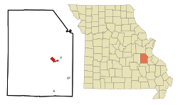
Fredericktown is a city in and the county seat of Madison County, Missouri, United States, in the northeastern foothills of the St. Francois Mountains. The population was 4,429 at the 2020 census, up from 3,985 in 2010. The city is surrounded on three sides by the easternmost parcel of the Mark Twain National Forest.

<span class="mw-page-title-main">Bonne Terre, Missouri</span> City in Missouri, United States

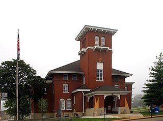
Bonne Terre is a city in St. Francois County, Missouri, United States with a population of 6,864 at the 2010 census. Situated in the Southeast Missouri Lead District, lead mining shaped the history and character of the area from the earliest French settlers in the 1720s until today, even though Bonne Terre Mine established by St. Joseph lead mining company in 1864 closed in 1962. Mine tailing piles eroded, and contaminated the area as dust, posing residential hazards or were washed into the Big River. Only in 1992, the Bonne Terre Mine Tailings Site was listed as a Superfund site; as of 2022 remediation is still ongoing.

<span class="mw-page-title-main">Desloge, Missouri</span> City in Missouri, United States

Desloge is a city in St. Francois County, Missouri, United States. The population was 5,054 as of the 2010 census.

<span class="mw-page-title-main">Glendale, Missouri</span> City in Missouri, United States

Glendale is a city in St. Louis County, Missouri, United States. The population was 5,925 at the 2010 census.

<span class="mw-page-title-main">Ste. Genevieve, Missouri</span> City in Missouri, United States

Ste. Genevieve is a city in Ste. Genevieve Township and is the county seat of Ste. Genevieve County, Missouri, United States. The population was 4,999 at the 2020 census. Founded in 1735 by French Canadian colonists and settlers from east of the river, it was the first organized European settlement west of the Mississippi River in present-day Missouri. Today, it is home to Ste. Genevieve National Historical Park, the 422nd unit of the National Park Service.

<span class="mw-page-title-main">Licking, Missouri</span> City in Missouri, United States

Licking is a city located in Texas County, Missouri, United States. The population was 3,124 at the 2010 census, making it the most populous city in Texas County.

<span class="mw-page-title-main">Mineral Point, Missouri</span> Village in Missouri, United States

Mineral Point is a village in Washington County, Missouri, United States. The population was 351 at the 2010 census.

<span class="mw-page-title-main">Diamond, Missouri</span> City in Missouri, United States

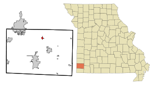
Diamond is a city in north central Newton County, Missouri, United States, located southeast of Joplin. The population was 831 at the 2020 census. It is part of the Joplin, Missouri, Metropolitan Statistical Area. Diamond is primarily renowned as the birthplace of George Washington Carver.

<span class="mw-page-title-main">Vandalia, Missouri</span> City in Missouri, United States

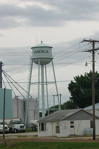
Vandalia is a city in northeastern Audrain and extending into southeastern Ralls Counties in the U.S. state of Missouri. The population was 3,553 at the 2020 census, which includes about 1,000 prisoners incarcerated at the prison located within the city limits.

<span class="mw-page-title-main">Potosi, Wisconsin</span> Village in Wisconsin, United States

Potosi is a village in Grant County, Wisconsin, United States. The population was 688 at the 2010 census. The village is in the Town of Potosi.

<span class="mw-page-title-main">Southeast Missouri Lead District</span> Lead mining area in Missouri, US

The Southeast Missouri Lead District, commonly called the Lead Belt, is a lead mining district in the southeastern part of Missouri. Counties in the Lead Belt include Saint Francois, Crawford, Dent, Iron, Madison, Reynolds, and Washington. This mining district is the most important and critical lead producer in the United States.

Desloge Consolidated Lead Company was a lead mining company in the Southeast Missouri Lead District that was operated by the Desloge family in the 19th and early 20th century. The Desloge lead operations in the "Old Lead Belt", in the eastern Ozark Mountains, helped Missouri become the world's premier lead mining area.

<span class="mw-page-title-main">Firmin V. Desloge</span> American industrialist

Firmin Vincent Desloge II was an American industrialist lead mining pioneer in the disseminated lead fields of the Southeast Missouri Lead District and member of the Desloge family in America.

<span class="mw-page-title-main">Firmin René Desloge</span>

Firmin René Desloge was a U.S. businessman who founded lead mines and other mercantile businesses. He was the progenitor of the Desloge Family in America, whose Missouri business interests included fur trading, hardware, clothing, lead mining, smelting and ore trading, and distilling.

The Desloge family, centered mostly in Missouri and especially at St. Louis, rose to wealth through international commerce, sugar refining, oil drilling, fur trading, mineral mining, saw milling, manufacturing, railroads, real estate, and riverboats. The family has funded hospitals and donated large tracts of land for public parks and conservation.

References

  1. 1 2 3 U.S. Geological Survey Geographic Names Information System: Potosi, Missouri
  2. "ArcGIS REST Services Directory". United States Census Bureau. Retrieved August 28, 2022.
  3. 1 2 "U.S. Census website". United States Census Bureau . Retrieved January 31, 2008.
  4. "Find a County". National Association of Counties. Retrieved June 7, 2011.
  5. "Moses Austin". Archived from the original on December 20, 2015. Retrieved February 11, 2010.
  6. "US Gazetteer files 2010". United States Census Bureau. Archived from the original on January 25, 2012. Retrieved July 8, 2012.
  7. "NowData – NOAA Online Weather Data". National Oceanic and Atmospheric Administration. Retrieved July 24, 2021.
  8. "Station: Potosi 4 SW, MO". U.S. Climate Normals 2020: U.S. Monthly Climate Normals (1991–2020). National Oceanic and Atmospheric Administration. Retrieved July 24, 2021.
  9. Christopher D Desloge, second great-grandson of Firmin Rene Desloge
  10. The Desloge Chronicles, 2011, by Christopher D Desloge
  11. Eaton, David Wolfe (1918). How Missouri Counties, Towns and Streams Were Named. The State Historical Society of Missouri. p. 370.
  12. "The Presbyterian Church - 1832 - Potosi, MO - Dated Architectural Structures Multifarious on Waymarking.com". www.waymarking.com.
  13. "Steroids for Sale Online - Buy Anabolic Steroids". www.prisontalk.com.
  14. "National Register Information System". National Register of Historic Places . National Park Service. July 9, 2010.
  15. "National Register of Historic Places Listings". Weekly List of Actions Taken on Properties: 10/24/11 through 10/28/11. National Park Service. November 4, 2011. Archived from the original on August 19, 2014. Retrieved March 4, 2017.
  16. "Census of Population and Housing". Census.gov. Retrieved June 4, 2015.
  17. "U.S. Census website". United States Census Bureau . Retrieved July 8, 2012.
  18. "Post Office Location - POTOSI Archived 2010-11-08 at the Wayback Machine ." United States Postal Service. Retrieved on September 18, 2010.
  19. "Institutional Facilities Archived 2010-05-27 at the Wayback Machine ." Missouri Department of Corrections. Retrieved on September 18, 2010. "Potosi Correctional Center (C-5)" "11593 State Highway O Mineral Point, MO 63660"
  20. Lombardi, George, Richard D. Sluder, and Donald Wallace. "The Management of Death-Sentenced Inmates: Issues, Realities, and Innovative Strategies Archived 2010-05-27 at the Wayback Machine ." Missouri Department of Corrections. 8-9. Retrieved on September 18, 2010.
  21. "Homepage". Potosi R-Iii School District. Retrieved June 4, 2019.
  22. "Missouri Public Libraries". PublicLibraries.com. Archived from the original on June 10, 2017. Retrieved June 2, 2019.