Greenville, Missouri

Last updated
Greenville, Missouri
Wayne County Missouri Incorporated and Unincorporated areas Greenville Highlighted.svg
Location of Greenville, Missouri
Coordinates: 37°07′38″N90°26′50″W / 37.12722°N 90.44722°W / 37.12722; -90.44722 Coordinates: 37°07′38″N90°26′50″W / 37.12722°N 90.44722°W / 37.12722; -90.44722
Country United States
State Missouri
County Wayne
Government
  MayorLarry Burchard
Area
[1]
  Total0.68 sq mi (1.75 km2)
  Land0.68 sq mi (1.75 km2)
  Water0.00 sq mi (0.00 km2)
Elevation
[2]
436 ft (133 m)
Population
 (2020)
  Total443
  Density656.30/sq mi (253.48/km2)
Time zone UTC-6 (Central (CST))
  Summer (DST) UTC-5 (CDT)
ZIP code
63944
Area code 573
FIPS code 29-29476 [3]
GNIS feature ID2394997 [2]

Greenville is a city located on U.S. Route 67 near the intersection with Route D and E in Wayne County, Missouri, United States, along the St. Francis River. The population was 443 at the 2020 census. [4] Greenville was incorporated and founded as the county seat of Wayne County in 1819. [5]

Contents

History

Greenville was named after Fort Greene Ville (now Greenville), Ohio, the site where General Anthony Wayne signed a treaty with the Native Americans after defeating them in the Battle of Fallen Timbers on August 20, 1794. [6] This was the final battle of the Northwest Indian War. Wayne County was named for this military hero and Greenville was named for the place he was most famous for. Incidentally, Fort Greene Ville, Ohio, was named after Nathanael Greene, a friend of Wayne.

In 1826, Greenville flooded. On August 10, 1832, the first post office opened. Confederate Brigadier General William J. Hardee and officers Patrick Cleburne, Thomas C. Hindman, and Basil W. Duke along with about 800 men were stationed close to Greenville near the outset of the Civil War until they began to retreat to Randolph County, Arkansas on August 28, 1861. On July 20, 1862, a camp of two companies of the 12th Missouri State Militia was attacked at daylight, surprising the camp, taking most of their rifles, 16 Savage revolvers, all of their horses, 50 pairs of holster pistols, and killing four of their men. [7]

Greenville was incorporated as a village on February 23, 1893. In 1941, the village was relocated two miles to the north after the construction of Lake Wappapello.

Old Greenville (23WE637) was listed on the National Register of Historic Places in 1990. [8]

Geography

Greenville is located on the southern edge of the Ozark Mountains, situated in a hilly, forested landscape. U.S. Route 67 passes through Greenville. According to the United States Census Bureau, the city has a total area of 0.68 square miles (1.76 km2), all land. [9] Greenville is on the east shore of Lake Wappapello, on the St. Francis River. [10]

Education

The Greenville R-2 School District runs throughout most of eastern Wayne County. There are two elementary schools—Greenville Elementary School and Williamsville Elementary School located in the nearby town of Williamsville for pre-kindergarten through sixth-grade students. Greenville Jr. High School (grades 7–8) and Greenville High School (grades 9-12) compose the remainder of the district. There are 762 students and 57 teachers in grades K-12 in the district. The school colors are red and black and its mascot is the bear. School athletics consist of boys' and girls' basketball, girls' volleyball, boys' baseball, girls' softball, and cheerleading. [11]

For adults aged 25 and older in Greenville, 26.7% possess a high school diploma or GED as their highest educational attainment and 5.5% possess a bachelor's degree or higher educational degree while 2.4% of the population possesses a post-graduate or professional degree.

Media

The single local newspaper is the weekly Wayne County Journal Banner. The Greenville Sun newspaper was published from 1893 to 1966.

Notable person

Demographics

Historical population
CensusPop.Note
1880 100
1900 1,051
1910 914−13.0%
1920 614−32.8%
1930 506−17.6%
1940 57213.0%
1950 270−52.8%
1960 2824.4%
1970 32816.3%
1980 39319.8%
1990 43711.2%
2000 4513.2%
2010 51113.3%
2020 443−13.3%
source: [12]

2010 census

As of the census [13] of 2010, there were 511 people, 192 households, and 121 families living in the city. The population density was 751.5 inhabitants per square mile (290.2/km2). There were 234 housing units at an average density of 344.1 per square mile (132.9/km2). The racial makeup of the city was 97.7% White, 0.2% African American, 0.4% Native American, 0.2% Asian, and 1.6% from two or more races. Hispanic or Latino of any race were 1.2% of the population.

There were 192 households, of which 31.3% had children under the age of 18 living with them, 47.9% were married couples living together, 12.0% had a female householder with no husband present, 3.1% had a male householder with no wife present, and 37.0% were non-families. 34.4% of all households were made up of individuals, and 16.7% had someone living alone who was 65 years of age or older. The average household size was 2.40 and the average family size was 3.10.

The median age in the city was 45.9 years. 21.7% of residents were under the age of 18; 7.3% were between the ages of 18 and 24; 20% were from 25 to 44; 27% were from 45 to 64; and 24.1% were 65 years of age or older. The gender makeup of the city was 47.2% male and 52.8% female.

2000 census

As of the census [3] of 2000, there were 451 people, 190 households, and 113 families living in the city. The population density was 674.3 inhabitants per square mile (260.3/km2). There were 222 housing units at an average density of 331.9 per square mile (128.1/km2). The racial makeup of the city was 98.67% White, 0.22% Native American, and 1.11% from two or more races. Hispanic or Latino of any race were 1.33% of the population.

There were 190 households, of which 28.9% had children under the age of 18 living with them, 47.4% were married couples living together, 10.0% had a female householder with no husband present, and 40.5% were non-families. 37.4% of all households were made up of individuals, and 22.1% had someone living alone who was 65 years of age or older. The average household size was 2.16 and the average family size was 2.85. It was reported that in Greenville, 1.1% of all households contain lesbians.

For people in the city aged 15 and over, 60.1% were married, 9.8% were divorced, 15.5% were single, never married, 11.9% were widowed, and 2.6% were separated.

In the city, the population was spread out, with 21.3% under the age of 18, 7.8% from 18 to 24, 25.5% from 25 to 44, 20.2% from 45 to 64, and 25.3% who were 65 years of age or older. The median age was 42 years. For every 100 females, there were 72.8 males. For every 100 females age 18 and over, there were 67.5 males.

The median income for a household in the city was $28,214, and the median income for a family was $39,375, and therefore lies at more than 30% below the national average. Males had a median income of $27,500 versus $17,656 for females. The per capita income for the city was $16,802. About 13.1% of families and 14.2% of the population were below the poverty line, including 20.4% of those under age 18 and 11.0% of those age 65 or over.

Related Research Articles

<span class="mw-page-title-main">Darke County, Ohio</span> County in Ohio, United States

Darke County is a county in the U.S. state of Ohio. As of the 2020 census, the population was 51,881. Its county seat and largest city is Greenville. The county was created in 1809 and later organized in 1817. It is named for William Darke, an officer in the American Revolutionary War. Darke County comprises the Greenville, OH Micropolitan Statistical Area, which is also included in the Dayton-Springfield-Sidney, OH Combined Statistical Area.

<span class="mw-page-title-main">Wayne County, Missouri</span> County in Missouri, United States

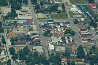
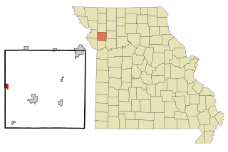
Wayne County is a county located in the Ozark foothills in the U.S. state of Missouri. As of the 2020 census, the population was 10,974. The county seat is Greenville. The county was officially organized on December 11, 1818, and is named after General "Mad" Anthony Wayne, who served in the American Revolution.

<span class="mw-page-title-main">Savannah, Missouri</span> City in Missouri, United States

Savannah is a city and county seat of Andrew County, Missouri, United States. The population was 5,069 at the 2020 census.

<span class="mw-page-title-main">Fairfax, Missouri</span> City in Missouri

Fairfax is a city in Clark Township, Atchison County, Missouri, United States. The population was 648 at the 2020 census.

<span class="mw-page-title-main">Ashland, Missouri</span> City in Missouri, United States

Ashland is a city in Boone County, Missouri, United States. Ashland is part of the Columbia, Missouri Metropolitan Statistical Area. The population was 4,747 at the 2020 census.

<span class="mw-page-title-main">Ellsinore, Missouri</span> City in Missouri, United States

Ellsinore is a town in Carter County, Missouri, United States. The 2020 U.S. Census showed Ellsinore with a population of 416.

<span class="mw-page-title-main">Kahoka, Missouri</span> City in Missouri, United States

Kahoka is a city in and the county seat of Clark County, in the northeast tip of Missouri, United States. As of the 2020 census, its population was 1,961.

<span class="mw-page-title-main">Hermitage, Missouri</span> City in Missouri, United States

Hermitage is a city in Hickory County, Missouri, United States, on the Pomme de Terre River. The population was 621 at the 2020 census. It is the county seat of Hickory County. The John Siddles Williams House on Museum Street in Hermitage, on the National Register of Historic Places since 1980, houses the Hickory County Historical Society Museum and Research Room.

<span class="mw-page-title-main">Linneus, Missouri</span> City in Missouri, United States

Linneus is a small city in Linn County, Missouri, United States. The population was 281 at the 2020 census. It is the county seat of Linn County.

<span class="mw-page-title-main">Center, Missouri</span> City in Missouri, United States

Center is a city in Ralls County, Missouri, United States. The population was 528 at the 2020 census. It is part of the Hannibal Micropolitan Statistical Area.

<span class="mw-page-title-main">Shelbyville, Missouri</span> City in Missouri, United States

Shelbyville is a city in Shelby County, Missouri, United States. The population was 518 at the 2020 census. It is the county seat of Shelby County.

<span class="mw-page-title-main">Essex, Missouri</span> City in Missouri, United States

Essex is a city in Stoddard County, Missouri, United States. The population was 472 at the 2010 census.

<span class="mw-page-title-main">Williamsville, Missouri</span> City in Missouri, United States

Williamsville is a city in Wayne County, Missouri, United States, along the Black River. The population was 279 at the 2020 census.

<span class="mw-page-title-main">Fordland, Missouri</span> City in Missouri, United States

Fordland is a city in southern Webster County, Missouri, United States. The population was 800 at the 2010 census. It is part of the Springfield, Missouri Metropolitan Statistical Area.

<span class="mw-page-title-main">Prairie Home, Missouri</span> City in Missouri, United States

Prairie Home is a town, with legal status as a city, in Cooper County, Missouri, United States. The population was 280 at the 2010 census.

Wade Hampton is a census-designated place (CDP) in Greenville County, South Carolina, United States. The population was 20,622 at the 2010 census. It is named for American Civil War general and South Carolina governor Wade Hampton.

<span class="mw-page-title-main">Gower, Missouri</span> City in Missouri, United States

Gower is a city in Buchanan and Clinton counties in the U.S. state of Missouri and is part of the Kansas City metropolitan area. The population was 1,526 at the 2010 census.

<span class="mw-page-title-main">Scott City, Missouri</span> City in Missouri, United States

Scott City is a city in Cape Girardeau and Scott counties in the U.S. state of Missouri. The population was 4,346 at the 2020 census. The Scott County portion of Scott City is part of the Sikeston Micropolitan Statistical Area, while the Cape Girardeau County portion is part of the Cape Girardeau–Jackson, MO-IL Metropolitan Statistical Area.

<span class="mw-page-title-main">Portageville, Missouri</span> City in Missouri, United States

Portageville is a city in New Madrid and Pemiscot counties in the U.S. state of Missouri. The population was 2,942 according to the 2020 Census.

<span class="mw-page-title-main">Rittman, Ohio</span> City in Ohio, United States

Rittman is a city in Medina and Wayne counties in the U.S. state of Ohio. All but a small portion of the city is in Wayne County, within commuting distance of Akron, Canton and Cleveland. The population was 6,491 at the 2010 census.

References

  1. "ArcGIS REST Services Directory". United States Census Bureau. Retrieved August 28, 2022.
  2. 1 2 U.S. Geological Survey Geographic Names Information System: Greenville, Missouri
  3. 1 2 "U.S. Census website". United States Census Bureau . Retrieved 2008-01-31.
  4. "Explore Census Data". data.census.gov. Retrieved 2022-01-09.
  5. "Find a County". National Association of Counties. Archived from the original on 2011-05-31. Retrieved 2011-06-07.
  6. Eaton, David Wolfe (1918). How Missouri Counties, Towns and Streams Were Named. The State Historical Society of Missouri. p. 371.
  7. United States, War Department. (1894). The War Of the Rebellion: A Compilation of the Official Records of the Union and Confederate Armies:[s.n.] Washington. pp. 166–171.
  8. "National Register Information System". National Register of Historic Places . National Park Service. July 9, 2010.
  9. "US Gazetteer files 2010". United States Census Bureau. Archived from the original on 2012-01-25. Retrieved 2012-07-08.
  10. Greenville, Missouri, 1966 (1985 rev.) and Greenville SW, Missouri, 1966 (1976 rev.), 7.5 Minute Topographic Quadrangles, USGS
  11. Greenville R-2 School District
  12. "Missouri Population 1900 - 1990" (PDF). Missouri Census Data Center. Archived from the original (CSV) on 4 July 2014. Retrieved 29 December 2013.
  13. "U.S. Census website". United States Census Bureau . Retrieved 2012-07-08.