Williamsville, Missouri

Last updated

Williamsville, Missouri
Wayne County Missouri Incorporated and Unincorporated areas Williamsville Highlighted.svg
Location of Williamsville, Missouri
Coordinates: 36°58′22″N90°32′53″W / 36.97278°N 90.54806°W / 36.97278; -90.54806
Country United States
State Missouri
County Wayne
Area
[1]
  Total0.32 sq mi (0.84 km2)
  Land0.32 sq mi (0.84 km2)
  Water0.00 sq mi (0.00 km2)
Elevation
[2]
400 ft (100 m)
Population
 (2020)
  Total279
  Density863.78/sq mi (333.15/km2)
Time zone UTC-6 (Central (CST))
  Summer (DST) UTC-5 (CDT)
ZIP code
63967
Area code 573
FIPS code 29-80026 [3]
GNIS feature ID2397321 [2]

Williamsville is a city in Wayne County, Missouri, United States, along the Black River. The population was 279 at the 2020 census. [4]

Contents

History

Williamsville was platted in 1871 when the railroad was extended to that point. [5] A post office called williamsville has been in operation since 1873. [6] The community's name is most likely derived from that of William Williams, the original owner of the town site. [5]

Geography

According to the United States Census Bureau, the city has a total area of 0.32 square miles (0.83 km2), all land. [7]

Demographics

Historical population
CensusPop.Note
1880 184
1890 435136.4%
1900 215−50.6%
1910 477121.9%
1920 448−6.1%
1930 428−4.5%
1940 51119.4%
1950 492−3.7%
1960 412−16.3%
1970 398−3.4%
1980 4185.0%
1990 391−6.5%
2000 379−3.1%
2010 342−9.8%
2020 279−18.4%
U.S. Decennial Census [8]

2010 census

As of the census [9] of 2010, there were 342 people, 148 households, and 98 families living in the city. The population density was 1,068.8 inhabitants per square mile (412.7/km2). There were 188 housing units at an average density of 587.5 per square mile (226.8/km2). The racial makeup of the city was 98.2% White, 0.3% African American, 0.3% Native American, and 1.2% from two or more races. Hispanic or Latino of any race were 0.9% of the population.

There were 148 households, of which 28.4% had children under the age of 18 living with them, 44.6% were married couples living together, 13.5% had a female householder with no husband present, 8.1% had a male householder with no wife present, and 33.8% were non-families. 29.7% of all households were made up of individuals, and 15.5% had someone living alone who was 65 years of age or older. The average household size was 2.31 and the average family size was 2.80.

The median age in the city was 44.5 years. 19.6% of residents were under the age of 18; 7.9% were between the ages of 18 and 24; 23.1% were from 25 to 44; 29.2% were from 45 to 64; and 20.2% were 65 years of age or older. The gender makeup of the city was 50.6% male and 49.4% female.

2000 census

As of the census [3] of 2000, there were 379 people, 161 households, and 108 families living in the city. The population density was 1,228.1 inhabitants per square mile (474.2/km2). There were 190 housing units at an average density of 615.7 per square mile (237.7/km2). The racial makeup of the city was 99.74% White and 0.26% Native American. Hispanic or Latino of any race were 0.26% of the population.

There were 161 households, out of which 28.6% had children under the age of 18 living with them, 54.7% were married couples living together, 10.6% had a female householder with no husband present, and 32.9% were non-families. 30.4% of all households were made up of individuals, and 19.9% had someone living alone who was 65 years of age or older. The average household size was 2.35 and the average family size was 2.87.

In the city the population was spread out, with 24.8% under the age of 18, 7.1% from 18 to 24, 24.8% from 25 to 44, 20.3% from 45 to 64, and 23.0% who were 65 years of age or older. The median age was 39 years. For every 100 females there were 93.4 males. For every 100 females age 18 and over, there were 87.5 males.

The median income for a household in the city was $21,111, and the median income for a family was $28,125. Males had a median income of $21,667 versus $20,288 for females. The per capita income for the city was $14,844. About 19.5% of families and 25.0% of the population were below the poverty line, including 38.1% of those under age 18 and 17.4% of those age 65 or over.

Related Research Articles

<span class="mw-page-title-main">Houston, Delaware</span> Town in Delaware, United States

Houston is a town in Kent County, Delaware, United States. It is part of the Dover metropolitan area. The population was 381 in 2020. It was named for John W. Houston.

<span class="mw-page-title-main">Athens, Illinois</span> City in Illinois, United States

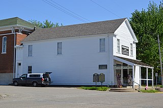
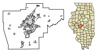
AthensAY-thənz is a city in Menard County, Illinois, United States. The population was 1,977 at the 2020 census. It is part of the Springfield, Illinois Metropolitan Statistical Area.

<span class="mw-page-title-main">Sherman, Illinois</span> Village in Illinois, United States

Sherman is a village in Sangamon County, Illinois, United States. The population was 4,148 at the 2010 census. It is part of the Springfield, Illinois Metropolitan Statistical Area. The village was hit by a high end EF-2 tornado in the March 31st outbreak.

<span class="mw-page-title-main">Williamsville, Illinois</span> Village in Illinois, United States

Williamsville is a village in Sangamon County, Illinois, United States. The population was 1,476 at the 2010 census, and 1,491 at a 2018 estimate. It is part of the Springfield, Illinois Metropolitan Statistical Area. The village is named after Springfield merchant and banker John Williams

<span class="mw-page-title-main">Fairbank, Iowa</span> City in Iowa, United States

Fairbank is a city in Buchanan and Fayette counties in the U.S. state of Iowa. The population was 1,111 at the time of the 2020 census.

<span class="mw-page-title-main">Maynard, Iowa</span> City in Iowa, United States

Maynard is a city in Fayette County, Iowa, United States. The population was 476 at the time of the 2020 census.

<span class="mw-page-title-main">Porter Township, Cass County, Michigan</span> Civil township in Michigan, United States

Porter Township is a civil township of Cass County in the U.S. state of Michigan. The population was 3,750 at the 2020 census.

<span class="mw-page-title-main">Lake Shore, Minnesota</span> City in Minnesota, United States

Lake Shore is a city in Cass County, Minnesota, United States. The population was 1,056 at the 2020 census. It is part of the Brainerd Micropolitan Statistical Area.

<span class="mw-page-title-main">Erhard, Minnesota</span> City in Minnesota, United States

Erhard is a city in Otter Tail County, Minnesota, United States. The population was 132 at the 2020 census.

<span class="mw-page-title-main">Urbank, Minnesota</span> City in Minnesota, United States

Urbank is a city in Otter Tail County, Minnesota, United States. The population was 52 at the 2020 census.

<span class="mw-page-title-main">Leonidas, Minnesota</span> City in Minnesota, United States

Leonidas is a city in Saint Louis County, Minnesota, United States. The population was 50 at the 2020 census.

<span class="mw-page-title-main">Clarkson Valley, Missouri</span> City in Missouri, United States

Clarkson Valley is a city in St. Louis County, Missouri, United States. The population was 2,609 at the 2020 census.

<span class="mw-page-title-main">Kramer, North Dakota</span> City in North Dakota, United States

Kramer is a city in Bottineau County, North Dakota, United States. The population was 24 at the 2020 census. Kramer was founded in 1905.

<span class="mw-page-title-main">North River, North Dakota</span> City in North Dakota, United States

North River is a city in Cass County, North Dakota, United States. The population was 55 at the 2020 census. North River was founded in 1973. It is a suburb/bedroom community directly adjacent to the city of Fargo.

<span class="mw-page-title-main">Dunes City, Oregon</span> City in Oregon, United States

Dunes City is a city in Lane County, Oregon, United States. The population was 1,303 at the 2010 census.

<span class="mw-page-title-main">Harrisburg, Oregon</span> City in Oregon, United States

Harrisburg is a city in Linn County, Oregon, United States. The population was 3,567 at the 2010 census.

<span class="mw-page-title-main">Franklin Township, Susquehanna County, Pennsylvania</span> Township in Pennsylvania, United States

Franklin Township is a township in Susquehanna County, Pennsylvania, United States. The population was 833 at the 2020 census. Salt Springs State Park, a Pennsylvania state park, is in Franklin Township.

<span class="mw-page-title-main">Crooks, South Dakota</span> City in South Dakota, United States

Crooks is a city in Minnehaha County, South Dakota, United States and is a suburb of Sioux Falls. The population was 1,362 at the 2020 census. Crooks was named New Hope until 1904. The town's present name honors W. A. Crooks, a local politician.

<span class="mw-page-title-main">Bancroft, West Virginia</span> Town in West Virginia, United States

Bancroft is a town in Putnam County, West Virginia, United States, along the Kanawha River. The population was 389 at the 2020 census. It is part of the Huntington–Ashland metropolitan area.

<span class="mw-page-title-main">Minnesota Lake, Minnesota</span> City in Minnesota, United States

Minnesota Lake is a city in Blue Earth and Faribault counties in the State of Minnesota. The population was 661 at the 2020 census. The bulk of the city is in Faribault County; a small part extends into Blue Earth County.

References

  1. "ArcGIS REST Services Directory". United States Census Bureau. Retrieved August 28, 2022.
  2. 1 2 U.S. Geological Survey Geographic Names Information System: Williamsville, Missouri
  3. 1 2 "U.S. Census website". United States Census Bureau . Retrieved January 31, 2008.
  4. "Explore Census Data". data.census.gov. Retrieved January 10, 2022.
  5. 1 2 "Wayne County Place Names, 1928–1945". The State Historical Society of Missouri. Archived from the original on June 24, 2016. Retrieved January 1, 2017.
  6. "Post Offices". Jim Forte Postal History. Retrieved January 1, 2017.
  7. "US Gazetteer files 2010". United States Census Bureau . Retrieved July 8, 2012.
  8. "Census of Population and Housing". Census.gov. Retrieved June 4, 2015.
  9. "U.S. Census website". United States Census Bureau . Retrieved July 8, 2012.