Paris, Missouri

Last updated

Paris, Missouri
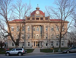
Monroe County Missouri Courthouse.JPG
The Monroe County Courthouse in Paris
Monroe County Missouri Incorporated and Unincorporated areas Paris Highlighted.svg
Location in Monroe County and the state of Missouri
Coordinates: 39°28′39″N92°0′14″W / 39.47750°N 92.00389°W / 39.47750; -92.00389
Country United States
State Missouri
County Monroe
Area
[1]
  Total1.27 sq mi (3.29 km2)
  Land1.26 sq mi (3.27 km2)
  Water0.01 sq mi (0.02 km2)
Elevation
[2]
679 ft (207 m)
Population
 (2020) [3]
  Total1,161
  Density919.24/sq mi (354.78/km2)
Time zone UTC-6 (Central (CST))
  Summer (DST) UTC-5 (CDT)
ZIP code
65275
Area code 660
FIPS code 29-56144 [4]
GNIS feature ID2396142 [2]
Website www.parismo.net

Paris is a city and county seat of Monroe County, Missouri, United States. The population was 1,161 at the 2020 census. [3]

Contents

History

Paris was platted in 1831, and named after Paris, Kentucky, the native home of one of the first settlers, Mrs. James C. Fox. James R. Abernathy was one of the first settlers in Paris in 1831. [5] The town was laid out in 1831 by Abernathy, James C. Fox, Hightower F. Hackney, and E. W. McBride. In 1837, Paris contained seven stores and a number of families. [6] On March 10, 1832, Abernathy and seven others organized the first Christian church in Paris. The church was built in a Gothic style of brick with four rooms at a cost of $11,000 (equivalent to $335,720in 2023). [7]

A post office called Paris has been in operation since 1841. [8]

The Paris Male Academy and Union Covered Bridge are listed on the National Register of Historic Places. [9]

Geography

Paris is in northeastern Missouri, in the center of Monroe County. U.S. Route 24 bypasses the city on the northwest side, leading northeast 21 miles (34 km) to Monroe City and west 26 miles (42 km) to Moberly. US 24 Business passes through the center of town, partly along Main Street. Missouri Route 15 passes through the center of Paris on Main Street, leading north 17 miles (27 km) to Shelbina and south 26 miles (42 km) to the city of Mexico. Missouri Route 154 leads east from Paris 19 miles (31 km) to Perry.

According to the U.S. Census Bureau, Paris has a total area of 1.27 square miles (3.29 km2), of which 0.01 square miles (0.03 km2), or 0.63%, are water. [1] The Middle Fork of the Salt River forms the northern border of the city; the river flows into Mark Twain Lake 3 miles (5 km) to the east.

Climate

The climate in this area is characterized by hot, humid summers and generally mild to cool winters. According to the Köppen Climate Classification system, Paris has a humid subtropical climate, abbreviated "Cfa" on climate maps. [10]

Demographics

Historical population
CensusPop.Note
1870 895
1880 1,25340.0%
1890 1,48718.7%
1900 1,397−6.1%
1910 1,4745.5%
1920 1,431−2.9%
1930 1,367−4.5%
1940 1,4737.8%
1950 1,407−4.5%
1960 1,393−1.0%
1970 1,4423.5%
1980 1,59810.8%
1990 1,486−7.0%
2000 1,5292.9%
2010 1,220−20.2%
2020 1,161−4.8%
U.S. Decennial Census [11]

2010 census

As of the census [12] of 2010, there were 1,220 people, 528 households, and 309 families living in the city. The population density was 983.9 inhabitants per square mile (379.9/km2). There were 643 housing units at an average density of 518.5 per square mile (200.2/km2). The racial makeup of the city was 93.7% White, 4.9% African American, 0.1% Native American, 0.2% Asian, 0.1% from other races, and 1.0% from two or more races. Hispanic or Latino of any race were 0.7% of the population.

There were 528 households, of which 24.8% had children under the age of 18 living with them, 43.2% were married couples living together, 10.4% had a female householder with no husband present, 4.9% had a male householder with no wife present, and 41.5% were non-families. 36.7% of all households were made up of individuals, and 21.8% had someone living alone who was 65 years of age or older. The average household size was 2.14 and the average family size was 2.77.

The median age in the city was 47.4 years. 19.8% of residents were under the age of 18; 6.9% were between the ages of 18 and 24; 21% were from 25 to 44; 24.5% were from 45 to 64; and 28% were 65 years of age or older. The gender makeup of the city was 43.8% male and 56.2% female.

2000 census

As of the census [4] of 2000, there were 1,529 people, 603 households, and 364 families living in the city. The population density was 1,228.5 inhabitants per square mile (474.3/km2). There were 682 housing units at an average density of 548.0 per square mile (211.6/km2). The racial makeup of the city was 92.15% White, 6.21% African American, 0.92% Native American, 0.07% Asian, and 0.65% from two or more races. Hispanic or Latino of any race were 0.46% of the population.

There were 603 households, out of which 27.0% had children under the age of 18 living with them, 48.4% were married couples living together, 9.1% had a female householder with no husband present, and 39.6% were non-families. 36.3% of all households were made up of individuals, and 22.6% had someone living alone who was 65 years of age or older. The average household size was 2.32 and the average family size was 3.03.

In the city, the population was spread out, with 22.8% under the age of 18, 7.3% from 18 to 24, 21.4% from 25 to 44, 20.0% from 45 to 64, and 28.5% who were 65 years of age or older. The median age was 44 years. For every 100 females, there were 84.7 males. For every 100 females age 18 and over, there were 77.7 males.

The median income for a household in the city was $29,556, and the median income for a family was $36,917. Males had a median income of $27,813 versus $18,580 for females. The per capita income for the city was $14,980. About 5.8% of families and 10.4% of the population were below the poverty line, including 10.1% of those under age 18 and 10.8% of those age 65 or over.
Education

Public education in the city is administered by Paris R-II School District, which operates one elementary school, one middle school, and Paris High School. [13]

Paris has a public library, a branch of the Little Dixie Regional Libraries. [14]

Notable people

Related Research Articles

<span class="mw-page-title-main">Layton, Florida</span> City in Florida, United States

Layton is a city located on the island of Long Key in Monroe County, Florida, United States. The City of Layton is part of the Florida Keys. The population was 210 at the 2020 census.

<span class="mw-page-title-main">Lansing, Kansas</span> City in Kansas, United States

Lansing is a city in Leavenworth County, Kansas, United States. It is situated along the west side of the Missouri River and Kansas-Missouri state border. As of the 2020 census, the population of the city was 11,239. It is the second most populous city of Leavenworth County and is a part of the Kansas City metropolitan area. The Lansing Correctional Facility, which includes the state's main maximum-security prison, is located in Lansing.

<span class="mw-page-title-main">Dundee, Michigan</span> Village in Michigan, United States

Dundee is a village in Monroe County in the U.S. state of Michigan. The population was 5,323 at the 2020 census, up from 3,957 in 2010. The village is within Dundee Township and is served by Dundee Community Schools.

<span class="mw-page-title-main">Smithville, Missouri</span> City in Missouri, United States

Smithville is a city in Clay and Platte counties in the U.S. state of Missouri and is part of the Kansas City metropolitan area, along the Little Platte River. The population was 10,406 at the 2020 United States Census.

<span class="mw-page-title-main">Old Monroe, Missouri</span> City in Lincoln County, Missouri, US

Old Monroe is a city in Lincoln County, Missouri, United States. The population was 249 at the 2020 census.

<span class="mw-page-title-main">Princeton, Missouri</span> City in Missouri, United States

Princeton is the county seat and largest city of Mercer County, Missouri, United States. The population was 1,007 at the 2020 census, down from the 2010 census, which counted 1,166 people. Princeton was the birthplace of the famous frontierswoman Calamity Jane.

<span class="mw-page-title-main">Eldon, Missouri</span> City in the state of Missouri

Eldon is a city in Miller County, Missouri, United States, located 30 miles (48 km) southwest of Jefferson City. The population was 4,416 as of the 2020 census.

<span class="mw-page-title-main">Madison, Missouri</span> City in Missouri, United States

Madison is a city in Monroe County, Missouri, United States. The population was 515 at the 2020 census.

<span class="mw-page-title-main">Stoutsville, Missouri</span> Village in Missouri, United States

Stoutsville is a village in Monroe County, Missouri, United States. The population was 37 at the 2020 census.

<span class="mw-page-title-main">Laurie, Missouri</span> City in Missouri, United States

Laurie is a city in southern Morgan and northern Camden counties, Missouri, United States. The population was 945 at the 2010 census.

<span class="mw-page-title-main">Freeburg, Missouri</span> Village in Missouri, United States

Freeburg is a village in Osage County, Missouri, United States. The population was 409 at the 2020 census. It is part of the Jefferson City, Missouri Metropolitan Statistical Area.

<span class="mw-page-title-main">Bolivar, Missouri</span> City in Missouri, United States

Bolivar is a city and county seat of Polk County, Missouri, United States.

<span class="mw-page-title-main">Hunnewell, Missouri</span> City in Missouri, United States

Hunnewell is a city in southeastern Shelby County, Missouri, United States. The population was 139 at the 2020 census.

<span class="mw-page-title-main">Shelbina, Missouri</span> City in Missouri, United States

Shelbina is a city in southern Shelby County, Missouri, United States. The population was 1,613 at the 2020 census.

<span class="mw-page-title-main">Dexter, Missouri</span> City in Missouri, United States

Dexter is a city in Stoddard County, Missouri, United States, founded in 1873. The population was 7,864 at the 2010 census.

QulinKEW-lin is a city located in Butler County in Southeast Missouri, United States. The population was 460 at the 2020 census.

New Deal is a U.S. town in Lubbock County, Texas. The population was 794 at the 2010 census. It is part of the Lubbock Metropolitan Statistical Area and the Llano Estacado region.

<span class="mw-page-title-main">Lake Ozark, Missouri</span> City in Missouri, United States

Lake Ozark is a city in Camden and Miller counties in the U.S. state of Missouri, near its namesake, the Lake of the Ozarks. The population was 2,077 at the 2020 census.

<span class="mw-page-title-main">Monroe City, Missouri</span> City in Missouri, United States

Monroe City is a city in Marion, Monroe, and Ralls counties in the U.S. state of Missouri. The population was 2,652 at the 2020 census.

<span class="mw-page-title-main">Portageville, Missouri</span> City in Missouri, United States

Portageville is a city in New Madrid and Pemiscot counties in the U.S. state of Missouri. The population was 2,942 according to the 2020 Census.

References

  1. 1 2 "2023 U.S. Gazetteer Files: Missouri". United States Census Bureau. Retrieved May 1, 2024.
  2. 1 2 U.S. Geological Survey Geographic Names Information System: Paris, Missouri
  3. 1 2 "P1. Race – Paris city, Missouri: 2020 DEC Redistricting Data (PL 94-171)". U.S. Census Bureau. Retrieved May 1, 2024.
  4. 1 2 "U.S. Census website". United States Census Bureau . Retrieved January 31, 2008.
  5. "Monroe County Place Names, 1928–1945". The State Historical Society of Missouri. Archived from the original on June 24, 2016. Retrieved May 29, 2022.
  6. Parker, Nathan H. (1867). Missouri as it is in 1867. J.B. Lippincott & co. p. 330. Retrieved May 28, 2022.{{cite book}}: |work= ignored (help)
  7. "Judge James R. Abernathy (Retired Attorney at Law, Paris". History of Monroe and Shelby Counties, Missouri. Chicago. 1884. Retrieved May 26, 2022.{{cite book}}: |work= ignored (help)CS1 maint: location missing publisher (link)
  8. "Post Offices". Jim Forte Postal History. Retrieved November 10, 2016.
  9. "National Register Information System". National Register of Historic Places . National Park Service. July 9, 2010.
  10. Climate Summary for Paris, Missouri
  11. "Census of Population and Housing". Census.gov. Retrieved June 4, 2015.
  12. "U.S. Census website". United States Census Bureau . Retrieved July 8, 2012.
  13. "Paris R-Ii School District". Great Schools. Retrieved June 2, 2019.
  14. "Branch Information". Little Dixie Regional Libraries. Retrieved June 2, 2019.
  15. Joint Committee On Printing, U.S. Congress (1928). Biographical Directory of the American Congress. 1774-1927. Washington, DC: U.S. Government Printing Office. p. 203 via Google Books.
  16. HOW DEAR TO MY HEART, by Mary Margaret McBride. The Macmillan Company 1940. Pgs. 119-120