Whittemore, Michigan

Last updated
Whittemore, Michigan
City of Whittemore
Whittemore, MI location.png
Location within Iosco County
USA Michigan location map.svg
Red pog.svg
Whittemore
Location within the state of Michigan
Usa edcp location map.svg
Red pog.svg
Whittemore
Location within the United States
Coordinates: 44°13′55″N83°48′16″W / 44.23194°N 83.80444°W / 44.23194; -83.80444
CountryUnited States
State Michigan
County Iosco
Settled1879
Incorporated1907
Government
[1]
   Mayor Bob Leslie
   Clerk Carol Long
Area
[2]
  Total1.02 sq mi (2.65 km2)
  Land1.02 sq mi (2.65 km2)
  Water0.00 sq mi (0.00 km2)
Elevation
778 ft (237 m)
Population
 (2020)
  Total414
  Density404.30/sq mi (156.03/km2)
Time zone UTC-5 (Eastern (EST))
  Summer (DST) UTC-4 (EDT)
ZIP code(s)
48770
Area code 989
FIPS code 26-87140 [3]
GNIS feature ID1616402 [4]

Whittemore is a city in Iosco County in the U.S. state of Michigan. The population was 414 at the 2020 census, which ranks it as the fourth-least populated city in the state after Omer, Lake Angelus, and Gaastra.

Contents

History

The village of Whittemore in Burleigh Township, Michigan was first settled in 1879 by David Belleknap, and named by a group of locals after Frank Whittemore. The post office began operating on April 13, 1880. Whittemore became politically independent of the township when it incorporated as a city in 1907. [5]

Geography

According to the U.S. Census Bureau, the city has a total area of 1.02 square miles (2.64 km2), all land. [2]

Major highways

Demographics

Historical population
CensusPop.Note
1910 218
1920 2326.4%
1930 36155.6%
1940 42016.3%
1950 4527.6%
1960 4601.8%
1970 4600.0%
1980 438−4.8%
1990 4635.7%
2000 4762.8%
2010 384−19.3%
2020 4147.8%
U.S. Decennial Census [6]

2010 census

As of the census [7] of 2010, there were 384 people, 183 households, and 96 families residing in the city. The population density was 387.9 inhabitants per square mile (149.8/km2). There were 226 housing units at an average density of 228.3 per square mile (88.1/km2). The racial makeup of the city was 94.8% White, 1.3% African American, 0.5% Native American, 1.3% from other races, and 2.1% from two or more races. Hispanic or Latino of any race were 3.1% of the population.

There were 183 households, of which 21.9% had children under the age of 18 living with them, 37.7% were married couples living together, 9.3% had a female householder with no husband present, 5.5% had a male householder with no wife present, and 47.5% were non-families. 39.3% of all households were made up of individuals, and 15.3% had someone living alone who was 65 years of age or older. The average household size was 2.10 and the average family size was 2.79.

The median age in the city was 47 years. 19% of residents were under the age of 18; 7.8% were between the ages of 18 and 24; 21.1% were from 25 to 44; 33.1% were from 45 to 64; and 19% were 65 years of age or older. The gender makeup of the city was 45.3% male and 54.7% female.

2000 census

As of the census [3] of 2000, there were 476 people, 197 households, and 127 families residing in the city. The population density was 483.1 inhabitants per square mile (186.5/km2). There were 225 housing units at an average density of 228.4 per square mile (88.2/km2). The racial makeup of the city was 98.74% White, 0.42% African American and 0.84% Native American. Hispanic or Latino of any race were 1.26% of the population.

There were 197 households, out of which 34.0% had children under the age of 18 living with them, 41.6% were married couples living together, 15.7% had a female householder with no husband present, and 35.5% were non-families. 32.0% of all households were made up of individuals, and 20.8% had someone living alone who was 65 years of age or older. The average household size was 2.42 and the average family size was 2.96.

In the city, the population was spread out, with 28.6% under the age of 18, 8.4% from 18 to 24, 26.5% from 25 to 44, 19.3% from 45 to 64, and 17.2% who were 65 years of age or older. The median age was 36 years. For every 100 females, there were 86.7 males. For every 100 females age 18 and over, there were 78.9 males.

The median income for a household in the city was $22,500, and the median income for a family was $26,375. Males had a median income of $26,875 versus $17,083 for females. The per capita income for the city was $12,175. About 21.1% of families and 24.6% of the population were below the poverty line, including 34.7% of those under age 18 and 13.3% of those age 65 or over.

Attractions

Whittemore Speedway is a racetrack located in the city of Whittemore, and it is Michigan's longest continuously running race track. [8]

Education

The city is served entirely by Whittemore-Prescott Area Schools. [9]

Shady Grove School is a private Amish elementary school serving approximately 20 students in grades 1–8.[ citation needed ]

Related Research Articles

<span class="mw-page-title-main">Iosco County, Michigan</span> County in Michigan, United States

Iosco County is a county in the U.S. state of Michigan; its eastern border is formed by Lake Huron. As of the 2020 census, the population was 25,237. The county seat is Tawas City.

<span class="mw-page-title-main">Whittemore, Iowa</span> City in Iowa, United States

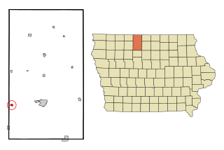
Whittemore is a city in Kossuth County, Iowa, United States. The population was 497 at the time of the 2020 census.

<span class="mw-page-title-main">Lincoln, Michigan</span> Village in Michigan, United States

Lincoln is a village in Alcona County in the U.S. state of Michigan. The population was 305 at the 2020 census.

Alabaster Township is a civil township of Iosco County in the U.S. state of Michigan. The 2020 census had the township population at 424.

Au Sable Township is a charter township of Iosco County in the U.S. state of Michigan. The population was 2,206 at the 2020 census.

Baldwin Township is a civil township of Iosco County in the U.S. state of Michigan. As of the 2000 census, the township population was 1,726.

Burleigh Township is a civil township of Iosco County in the U.S. state of Michigan. As of the 2000 census, the township population was 775.

<span class="mw-page-title-main">East Tawas, Michigan</span> City in Michigan, United States

East Tawas is a city in Iosco County in the U.S. state of Michigan. The population was 2,663 at the 2020 census.

Grant Township is a civil township of Iosco County in the U.S. state of Michigan. At the 2000 census the township population was 1,560.

<span class="mw-page-title-main">Oscoda Township, Michigan</span> Charter township in Michigan, United States

Oscoda Township is a charter township of Iosco County in the U.S. state of Michigan. The population was 6,788 at the 2020 census. The Wurtsmith Air Force Base is located within the township.

Plainfield Township is a civil township of Iosco County in the U.S. state of Michigan. The population was 3,799 at the 2010 census, down from 4,292 at the 2000 census.

Reno Township is a civil township of Iosco County in the U.S. state of Michigan. The population was 656 at the 2000 census.

Sherman Township is a civil township of Iosco County in the U.S. state of Michigan. The population was 493 at the 2000 census and slightly decreased to 448 at the 2010 census.

Tawas Township is a civil township of Iosco County in the U.S. state of Michigan. The population was 1,684 at the 2000 census. Tawas City is adjacent to the township.

Tawas City is a city in and county seat of Iosco County in the U.S. state of Michigan. The population was 1,834 at the 2020 census. The city is mostly surrounded by Tawas Township, but the two areas are administered autonomously.

Wilber Township is a civil township of Iosco County in the U.S. state of Michigan. The population was 740 at the 2000 census.

<span class="mw-page-title-main">Iosco Township, Michigan</span> Civil township in Michigan, United States

Iosco Township is a civil township of Livingston County in the U.S. state of Michigan. The population was 3,801 at the 2010 census, up from 3,039 at the 2000 census.

<span class="mw-page-title-main">Goodar Township, Michigan</span> Civil township in Michigan, United States

Goodar Township is a civil township of Ogemaw County in the U.S. state of Michigan. The population was 398 at the 2010 census, which makes it the least-populated municipality in the county.

<span class="mw-page-title-main">Ferrysburg, Michigan</span> City in Michigan, United States

Ferrysburg is a city in Ottawa County in the U.S. state of Michigan. The population was 2,892 at the 2010 census.

<span class="mw-page-title-main">Hartford, Michigan</span> City in Michigan, United States

Hartford is a city in Van Buren County in the U.S. state of Michigan. The population was 2,688 at the 2010 census. The city is located within Hartford Township, but is politically independent.

References

  1. "Iosco County, Michigan: Government Contacts". 2022. Retrieved November 22, 2022.
  2. 1 2 "2020 U.S. Gazetteer Files". United States Census Bureau. Retrieved May 21, 2022.
  3. 1 2 "U.S. Census website". United States Census Bureau . Retrieved 2008-01-31.
  4. U.S. Geological Survey Geographic Names Information System: Whittemore, Michigan
  5. Romig, Walter (October 1, 1986) [1973]. Michigan Place Names: The History of the Founding and the Naming of More Than Five Thousand Past and Present Michigan Communities. p. 603. ISBN   978-0-8143-1838-6.{{cite book}}: |work= ignored (help)
  6. "Census of Population and Housing". Census.gov. Retrieved June 4, 2015.
  7. "U.S. Census website". United States Census Bureau . Retrieved 2012-11-25.
  8. "The 18 tiniest cities in Michigan". Flint Journal. Mlive Media Group. December 4, 2016. p. 18. Retrieved December 5, 2016.
  9. Michigan Geographic Framework (15 November 2013). "Iosco County School Districts" (PDF). Retrieved August 28, 2022.