Azerley is a hamlet and civil parish in the Harrogate district of North Yorkshire, England. It is about 4 miles (6 km) north-west of Ripon.
Birdsall is a village and civil parish in North Yorkshire, England. According to the 2001 census it had a population of 180, increasing to 343 at the 2011 Census. The village is about four miles south of Malton and the parish also includes the village of North Grimston.
Brompton is a civil parish in the Scarborough district of North Yorkshire, England, containing the villages of Brompton-by-Sawdon and Sawdon.

Broughton is a village and civil parish in the former Craven District of North Yorkshire, England. The village is on the A59 road approximately 3 miles (5 km) west of Skipton.

Leake is a hamlet and civil parish in the Hambleton district of North Yorkshire, England, about six miles north of Thirsk. The population of the parish was estimated at 10 in 2010. With the population in 2011 being less than 100 information is contained in the civil parish of Borrowby, Hambleton.

Sheriff Hutton is a village and civil parish in North Yorkshire, England. It lies about 10 miles (16 km) north by north-east of York.

Firby is a small village and civil parish in North Yorkshire, England. It lies 1-mile (1.5 km) south of Bedale. The population of the parish was estimated at 30 in 2015. At the 2011 Census the population was included with the civil parish of Bedale, and not counted separately.

Ingleby Arncliffe is a village and civil parish in North Yorkshire, England. It is situated between the A172 and A19 roads, 6.5 miles (10.5 km) north-east from Northallerton and 7 miles (11.3 km) south-east from the small market town of Stokesley, and is on the edge of the North York Moors National Park. The village is conjoined to its smaller neighbour, Ingleby Cross. Ingleby Arncliffe lies in the historic county of the North Riding of Yorkshire.

Eryholme is a village and civil parish in North Yorkshire, England. As the population remained less than 100 in the 2011 census, information is included with that of Dalton-on-Tees.

Worton is a hamlet in Wensleydale in the Yorkshire Dales in the Richmondshire district of North Yorkshire, England. It lies 1-mile (1.6 km) east of Bainbridge on the A684 road, 4 miles (6.4 km) west of Aysgarth and 1-mile (1.6 km) south east of Askrigg. The hamlet is just south of the River Ure, the biggest river in Wensleydale. The hamlet is named in the Domesday Book and its name derives from the Old English wyrt-tūn and means the garden.

Wykeham is a small village and civil parish in the Scarborough district of North Yorkshire, England, on the outskirts of Scarborough and the southern boundary of the North York Moors National Park.

Preston-under-Scar is a village and civil parish in North Yorkshire, England. It is situated approximately 2 miles (4 km) west of Leyburn. The village population was 120 at the 2001 census, increasing to 170 by the 2011 census. The village is mentioned in the Domesday Book as belonging to Thorfin of Ravensworth, but the tenant-in-chief being Count Alan of Bedale. The name of the village derives form a mixture of Old English and Old Norse and was originally prēost tūn sker, which translates as Priests farm under rock.

Kirkby is a village and civil parish in Hambleton district of North Yorkshire, England, near Great Busby and 2 miles (3.2 km) south of Stokesley. The village is mentioned in the Domesday Book as belonging to Uhtred. The name of the village derives from the Old Norse kirkju-býr, which means church with a village. At the 2001 Census, the population of the village was recorded at 313, dropping slightly to 309 at the 2011 Census. In 2015, North Yorkshire County Council estimated the population to be 310.
Potto is a village and civil parish in the Hambleton district of North Yorkshire, England. It is 5 miles south-west of Stokesley and near the main A172 road. Potto has a pub, a church and a haulage company.

Seamer is a village and civil parish in the Hambleton district of North Yorkshire, England, near the border with the Borough of Stockton-on-Tees and 2 miles (3 km) northwest of Stokesley. According to the 2011 census, the population of the village was 566, which North Yorkshire County Council estimated had dropped to 560 by 2015.

Coverham Abbey, North Yorkshire, England, was a Premonstratensian monastery that was founded at Swainby in 1190 by Helewisia, daughter of the Chief Justiciar Ranulf de Glanville. It was refounded at Coverham in about 1212 by her son Ranulf fitzRalph, who had the body of his late mother reinterred in the chapter house at Coverham.

Swainby is a village in the Hambleton District of North Yorkshire, England. It is situated on the A172 road, 8 miles (13 km) north-east from Northallerton and 5 miles (8 km) south-east from the small market town of Stokesley.

Normanby is a village and civil parish in the Ryedale district of North Yorkshire, England. It is about 4 miles (6.4 km) west of Pickering. It lies on the main road between Malton and Kirkbymoorside.

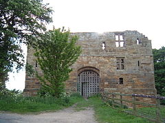
Whorlton Castle is a ruined medieval castle situated near the abandoned village of Whorlton in North Yorkshire, England. It was established in the early 12th century as a Norman motte-and-bailey associated with the nearby settlement. The castle is an unusual example of a motte-and-bailey that remained in use throughout the Middle Ages and into the early modern period.
St Martin's is a civil parish in North Yorkshire, England. It is located south of the town of Richmond, covering the residential areas south of the River Swale, including the former Richmond railway station and Holly Hill.