
Thayer Street in Providence, Rhode Island is a popular destination for students of the area's nearby schools of Brown University, Moses Brown School, Hope High School, Wheeler School, RISD, Providence College, Johnson & Wales University, and Rhode Island College.

Classical High School, founded in 1843, is a public magnet school in the Providence School District, in Providence, Rhode Island. It was originally an all-male school but has since become co-ed. Classical's motto is Certare, Petere, Reperire, Neque Cedere, a Latin translation of the famous phrase taken from Tennyson's poem "Ulysses", "To Strive, to Seek, to Find, and Not to Yield". It has been rated "High Performing and Sustaining" by its performance in 2005 on the New Standards Reference Exam, placing third in the state. The school also made Newsweek's America's Best High Schools of 2012 with a 99% graduation rate, 95% college bound, an average SAT score of 1578, and an average AP score of 2.8. Classical High School stands roughly at the intersection of the Federal Hill, West End, and Upper South Providence neighborhoods.

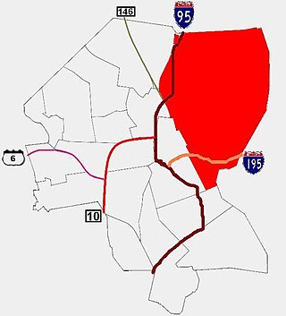
Federal Hill is a neighborhood in Providence, Rhode Island. It lies immediately west of the city's Downtown, across Interstate 95. Since the late 19th century, Federal Hill has been an enclave of Providence's Italian American community; today the neighborhood is known as Providence's Little Italy and is noted for its abundance of Italian restaurants, markets, and cultural establishments.

Smith Hill is a neighborhood in Providence, Rhode Island. Its traditional bounds are the Woonasquatucket River, the Chad Brown public housing complex, Interstate 95 and West River.
AS220 is a non-profit community arts center located in Downtown, Providence, Rhode Island, United States. AS220 maintains four dozen artist live/work studios, around a dozen individual work studios, six rotating exhibition spaces, a main stage, a black box theater, a dance studio, a print shop, a community darkroom, a digital media lab, a fabrication lab, an organization-run bar and restaurant, a youth recording studio, and a youth program. AS220 is an unjuried and uncensored forum for the arts, open to all ages.

Blackstone is a predominantly residential neighborhood in Providence, Rhode Island. It is in the northeast corner of the city and is bounded to the south and west by Lloyd Avenue and Hope Street respectively. It is one of six neighborhoods comprising the East Side of Providence.

College Hill is a historic neighborhood of Providence, Rhode Island, and one of six neighborhoods comprising the city's East Side. It is roughly bounded by South and North Main Street to the west, Power Street to the south, Governor Street and Arlington Avenue to the east and Olney Street to the north. The neighborhood's primary commercial area extends along Thayer Street, a strip frequented by students in the Providence area.

Fox Point is a neighborhood in the East Side of Providence, Rhode Island. It is bounded by the Providence and Seekonk rivers, Interstate 195 and the College Hill and Wayland neighborhoods. Fox Point is the southernmost neighborhood in the East Side area of Providence.
The East Side is a collection of neighborhoods in the eastern part of the city of Providence, Rhode Island. It officially comprises the neighborhoods of Blackstone, Hope, Mount Hope, College Hill, Wayland, and Fox Point.

The Community College of Rhode Island (CCRI) is a public community college in Rhode Island. It is the only community college in the state and the largest community college in New England. The college's primary facility is located in Warwick, with additional college buildings throughout the state.
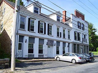
Forestdale is a village and historic district in North Smithfield, Providence County, Rhode Island, United States, one-half mile from Slatersville, Rhode Island. The historic district runs east and west along Main Street and north on Maple Avenue. School Street is the primary road through the village, and the one-room schoolhouse for which the street is named still stands. The Branch River runs through the valley adjacent to the School Street. The Village Haven Restaurant and local VFW chapter are also located in the village.
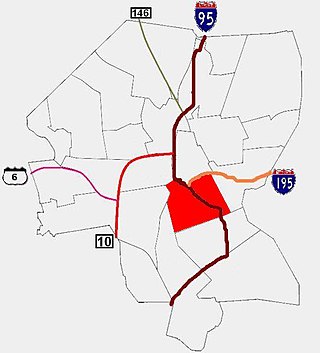
Upper South Providence is an official neighborhood in the South Side in the city of Providence, Rhode Island. It is bound to the north by Interstate 95, the east by the Providence River, to the south by Public Street, and the west by Broad Street. Often associated with Lower South Providence directly to its south, Upper South Providence is a distinct neighborhood.
WELH is a radio station owned by The Wheeler School of Providence, Rhode Island. Originally signing on in January 1995 with a pop alternative format and a line up of student DJs, WWKX veterans including Kickin Al Snape, a young Robby Bridges and others as "WELH: Taking Music to New Heights". In 1996 the station moved to a modern rock format programmed by student DJs as "Extreme 88", and later jazz and oldies, eventually offering programming from various groups. From October 8, 2011 until September 30, 2021, WELH broadcast programming from Rhode Island Public Radio.

The College Hill Historic District is located in the College Hill neighborhood of Providence, Rhode Island. It was designated a National Historic Landmark District on December 30, 1970. The College Hill local historic district, established in 1960, partially overlaps the national landmark district. Properties within the local historic district are regulated by the city's historic district zoning ordinance, and cannot be altered without approval from the Providence Historic District Commission.

Market Square is a market square in Providence, Rhode Island. It is located at the intersection of present-day North Main Street and College Street at the base of College Hill. Market Square has historically functioned as a commercial, civic, and cultural locus of Providence.

Providence is the capital and most populous city of the U.S. state of Rhode Island. One of the oldest cities in New England, it was founded in 1636 by Roger Williams, a Reformed Baptist theologian and religious exile from the Massachusetts Bay Colony. He named the area in honor of "God's merciful Providence" which he believed was responsible for revealing such a haven for him and his followers. The city developed as a busy port as it is situated at the mouth of the Providence River in Providence County, at the head of Narragansett Bay.
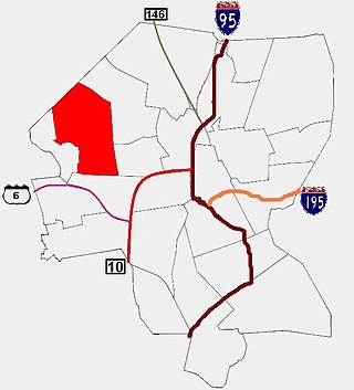
Mount Pleasant is a working-class residential neighborhood situated in the northwest of the city of Providence, Rhode Island. It is bordered by Olneyville to the south, Valley to the east, Manton to the west, and Elmhurst to the northeast, and the Town of North Providence to the north. The major street boundaries that define Mount Pleasant are Academy Avenue to the east, Smith Street to the northeast, Atwells Avenue to the south, and portions of Bullock, Chalkstone, Mera, and Rushmore Avenues to the west.
Hope Street is a major two lane bidirectional street running about three miles north to south on the East Side of Providence, Rhode Island. The street serves as a main artery serving most of the East Side district and connects the East Side to Pawtucket at the north, where it continues as East Avenue.

Wayland Square is a historic area on the East Side of Providence, Rhode Island near Brown University and the Rhode Island School of Design.
The following is a timeline of the history of the city of Providence, Rhode Island, United States.


