
Lichfield is a local government district in Staffordshire, England. It is administered by Lichfield District Council, based in Lichfield.

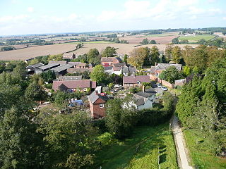
Hopwas is a village in Staffordshire, England. It lies along the North West borders of Tamworth Borough and 5 miles (8 km) east of Lichfield. It is situated where the A51 road crosses both the River Tame and the Coventry Canal. Although adjacent to the Borough of Tamworth, the village is part of the parish of Wigginton and Hopwas within Lichfield District.

Edingale is a village and civil parish in Lichfield District, Staffordshire, England. It lies on the River Mease, around 7 miles (11 km) north of Tamworth. Historically, the village is shared with Derbyshire. In 2001 the parish had a population of 598, increasing to 632 at the 2011 census.

Whittington is a village and civil parish which lies approximately 3 miles south east of Lichfield, in the Lichfield district of Staffordshire, England. According to the 2001 census it had a population of 2,591, increasing to 2,603 at the 2011 Census. The parish council is a joint one with Fisherwick. The Coventry Canal borders the village to the north and east.

Statfold is a former village in Staffordshire, England, about 3 miles (5 km) north-east of Tamworth. Population details as taken at the 2011 census can be found under Clifton Campville. These days little remains of the village itself, but the Norman parish church, and the Tudor manor house of Statfold Hall still exist, as do a few scattered farms and houses.
Fradley is a village and former civil parish, now in the parish of Fradley and Streethay, in the Lichfield district, in the county of Staffordshire, England. In 1881 the parish had a population of 380.

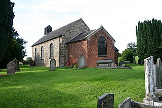
Hints is a small village and civil parish between Lichfield and Tamworth in southeastern Staffordshire, within Lichfield local government district. The village is on the line of Watling Street, which was formerly the A5, but the A5 now runs in a cutting north of the village. The name of the parish council is Hints with Canwell. The parish church is dedicated to St Bartholomew.
Comberford is a small settlement in Staffordshire, England. It lies by the River Tame, about 4 kilometres (2 mi) north-east of Tamworth along the A513 road. Historically part of the parish of Wigginton, it is now within the Wigginton and Hopwas civil parish in the district of Lichfield.

Orgreave is a hamlet and former civil parish, now in the parish of Alrewas, in the Lichfield district, in the county of Staffordshire, England. It lies in the Trent Valley some 6+1⁄2 miles (10.5 km) north-east of the city of Lichfield, the A513 road runs to the south of the hamlet. In 1881 the parish had a population of 113.

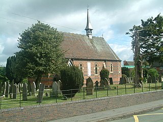
St Chad's Church is in the village of Hopwas, Staffordshire, England. It is an active Anglican parish church in the deanery of Tamworth, the archdeaconry of Lichfield and the diocese of Lichfield. Its benefice is combined with those of St Editha, Tamworth, St Francis, Leyfields, and St Andrew, Kettlebrook. The church is recorded in the National Heritage List for England as a designated Grade II listed building.

Croxall is a hamlet and former civil parish, now in the parish of Edingale, in the Lichfield district, in the county of Staffordshire, England. The settlement today is mainly the Church of England parish church of St John and Croxall Hall. On 30 September 1895 the part in Derbyshire was transferred to Staffordshire meaning Croxall was entirely in Staffordshire. In 1931 the parish had a population of 184.
Clifton Campville is a village, former manor and civil parish in Staffordshire, England. It lies on the River Mease, about 10 miles (16 km) east of the City of Lichfield, 6 miles (10 km) west of Measham and 7 miles (11 km) north of Tamworth. The village lies close to Staffordshire's borders with Derbyshire, Leicestershire and Warwickshire. The parish, which includes Haunton village, had a population of 912 at the 2011 census. There is a fine gothic church, dedicated to St Andrew, and listed Grade I. The village pub, The Green Man, is also a historic building.

Harlaston is a village and civil parish in Staffordshire, England. It lies on the River Mease, about 5 miles (8 km) north of Tamworth. There is an Early English church, dedicated to St Matthew, and a public house, the White Lion.

Thorpe Constantine is a small village and civil parish in Staffordshire, England. It lies about 6 miles (10 km) north-east of Tamworth and 6 miles south-west of Measham. The nucleus of the parish is the Thorpe estate.
Wigginton and Hopwas is a civil parish in Lichfield District, Staffordshire, England. The villages of Wigginton and Hopwas, that make up the parish, lie 2 miles to the north and north-west, respectively, of Tamworth. They are separated by the River Tame, the Coventry Canal and the West Coast Main Line. The parish also includes the hamlet of Comberford.
Haunton is a village in Staffordshire, England. It lies on the River Mease, about 7 miles (11 km) north of Tamworth, 1½ miles east of Harlaston and 1 mile west of Clifton Campville where population details as taken at the 2011 census can be found.
Wigginton and Hopwas is a civil parish in the district of Lichfield, Staffordshire, England. The parish contains 16 listed buildings that are recorded in the National Heritage List for England. All the listed buildings are designated at Grade II, the lowest of the three grades, which is applied to "buildings of national importance and special interest". The parish contains the villages of Wigginton and Hopwas and the surrounding countryside. Most of the listed buildings are houses and farmhouses, and the other listed buildings include two churches, a former pumping station, a pump house, a war memorial and a milepost.

Pipehill is a hamlet and former civil parish, now in the parish of Hammerwich, in the Lichfield district, in the county of Staffordshire, England. It is located between Wall and Hammerwich. In 1891 the parish had a population of 139.

Cauldon or Caldon is a village and former civil parish, 19 miles (31 km) north east of Stafford, now in the parish of Waterhouses, in the Staffordshire Moorlands district, in the county of Staffordshire, England. In 1931 the parish had a population of 422.
Marston is a village and civil parish 12 miles (19 km) south of Stoke-on-Trent, in the Stafford district, in the county of Staffordshire, England. In 2011 the parish had a population of 158. The parish touches Creswell, Hopton and Coton, Salt and Enson, Sandon and Burston, Stone Rural and Whitgreave.

