
Dumfries and Galloway is one of the 32 unitary council areas of Scotland, located in the western part of the Southern Uplands. It is bordered by East Ayrshire, South Ayrshire, and South Lanarkshire to the north; Scottish Borders to the north-east; the English ceremonial county of Cumbria, the Solway Firth, and the Irish Sea to the south, and the North Channel to the west. The administrative centre and largest settlement is the town of Dumfries. The second largest town is Stranraer, located 76 miles (122 km) to the west of Dumfries on the North Channel coast.

Kirkcudbrightshire, or the County of Kirkcudbright or the Stewartry of Kirkcudbright is one of the historic counties of Scotland, covering an area in the south-west of the country. Until 1975, Kirkcudbrightshire was an administrative county used for local government. Since 1975, the area has formed part of Dumfries and Galloway for local government purposes. Kirkcudbrightshire continues to be used as a registration county for land registration. A lower-tier district called Stewartry covered the majority of the historic county from 1975 to 1996. The area of Stewartry district is still used as a lieutenancy area. Dumfries and Galloway Council also has a Stewartry area committee.
Wigtownshire or the County of Wigtown is one of the historic counties of Scotland, covering an area in the south-west of the country. Until 1975, Wigtownshire was an administrative county used for local government. Since 1975 the area has formed part of Dumfries and Galloway for local government purposes. Wigtownshire continues to be used as a territory for land registration, being a registration county. The historic county is all within the slightly larger Wigtown Area, which is one of the lieutenancy areas of Scotland and was used in local government as the Wigtown District from 1975 to 1996.

Annandale and Eskdale is a committee area in Dumfries and Galloway, Scotland. It covers the areas of Annandale and Eskdale, the straths of the River Annan and the River Esk respectively. From 1975 until 1996 it was a local government district.

Nithsdale, also known as Strathnith, Stranith or Stranit, is the strath or dale of the River Nith in southern Scotland. Nithsdale was one of the medieval provinces of Scotland. The provinces gradually lost their administrative importance to the shires created from the twelfth century, with Nithsdale forming part of Dumfriesshire. A Nithsdale district covering a similar area to the medieval province was created in 1975, based in the area's main town of Dumfries. The district was abolished in 1996, since when the area has been directly administered by Dumfries and Galloway Council.
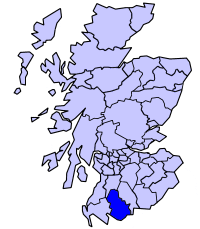
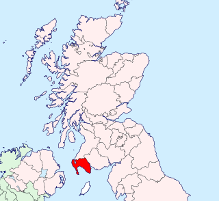
Stewartry was a local government district from 1975 until 1996 within the Dumfries and Galloway region in south-west Scotland. Under the name Stewartry of Kirkcudbright the area of the former district is still used as a lieutenancy area. Dumfries and Galloway Council has a Stewartry area committee which approximately covers the same area, subject to some adjustments where ward boundaries no longer follow the pre-1996 district boundary. Stewartry covers the majority of the historic county of Kirkcudbrightshire, and derives its name from the county's alternative name of the "Stewartry of Kirkcudbright".

Kyle and Carrick was one of nineteen local government districts in the Strathclyde region of Scotland from 1975 to 1996.

Gatehouse of Fleet is a town half in the civil parish of Girthon and half in the parish of Anwoth, divided by the river Fleet, Kirkcudbrightshire, within the district council region of Dumfries and Galloway, Scotland, which has existed since the mid-18th century, although the area has been inhabited since much earlier.
This is a list of people who have served as Lord Lieutenant of Wigtown, part of the Dumfries and Galloway council area of south-west Scotland. Prior to 1975 the lieutenancy area corresponded to the historic county of Wigtownshire. Since 1975 the lieutenancy area has been the slightly larger Wigtown Area, covering the historic county plus the two parishes of Kirkmabreck and Minnigaff from Kirkcudbrightshire.

New Abbey is a village in the historical county of Kirkcudbrightshire in Dumfries and Galloway, Scotland. It is 6 miles (10 km) south of Dumfries. The summit of the prominent hill Criffel is 2.5 miles (4.0 km) to the south.

Terregles is a village and civil parish near Dumfries, in Dumfries and Galloway, Scotland. It lies in the former county of Kirkcudbrightshire.

Kirkbean is a Scottish village and civil parish on the Solway Firth, in the historic county of Kirkcudbrightshire and council area of Dumfries and Galloway. In the 2001 census, the four small villages making up the parish of Kirkbean had a total population of 643. It includes the hamlet of Loaningfoot.
Minnigaff is a village and civil parish in the historic county of Kirkcudbrightshire in Dumfries and Galloway, Scotland. Lead was discovered there in 1763 and mined about two miles from the village until 1839.

The River Cree is a river in Dumfries and Galloway, Scotland which runs through Newton Stewart and into the Solway Firth. It forms part of the boundary between the counties of Wigtownshire and Kirkcudbrightshire. The tributaries of the Cree are the Minnoch, Trool, Penkiln and Palnure which drain from the Range of the Awful Hand, the labyrinthine range of mountains and lochs, bogs, burns and crags, rising at its highest to The Merrick, Galloway, 12 miles north and visible from Newton Stewart.

Troqueer is a former village and a parish in the historic county of Kirkcudbrightshire in Dumfries and Galloway on the west side of the River Nith. The eastern-side was merged with Dumfries to the east in 1929, and today eastern Troqueer is a suburb of Dumfries.

Wigtown Harbour or Wigtown Quay was relocated in 1818 to serve the town of Wigtown and its hinterland in Wigtownshire, Dumfries and Galloway, following the silting up of the original natural harbour that was originally located near to St Machute's church. This relocation occurred following centuries of silting and then the alteration of the course of the River Bladnoch that runs into Wigtown Bay where it joins the River Cree.

Kirkmabreck is a civil parish in the historic county of Kirkcudbrightshire in the Dumfries and Galloway council area, Scotland.
Palnure railway station (NX450634) was a railway station on the Portpatrick and Wigtownshire Joint Railway close to Newton Stewart and the junction for the branch to Whithorn via Wigtown. It served the small village of Palnure in a rural area of the old county of Kirkcudbrightshire, Parish of Minnigaff, Dumfries And Galloway.

Wigtown County Buildings, also known as Wigtown County Buildings and Town Hall, is a municipal building in The Square, Wigtown, Scotland. The structure primarily served as the meeting place and town hall for Wigtown Burgh Council, but was also used for some meetings of Wigtownshire County Council. It is a Category B listed building.

County Buildings is a municipal building in Kirkcudbright, in the Dumfries and Galloway council area in Scotland. It was originally two houses on High Street, which then served as the main offices of Kirkcudbrightshire County Council from 1925 to 1975. A large extension to the rear was added in 1952, accessed from Daar Road. From 1975 until 1996 the building served as the offices of Stewartry District Council. Since 1996, it has been an area office of Dumfries and Galloway Council. It is a Category B listed building. Prior to the 1952 extension the name "County Buildings" was used for a different building, at 85 High Street, which was also the town's sheriff court.

