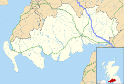
Kirkmabreck

Last updated

Kirkmabreck
Kilmabreck Church - geograph.org.uk - 313079.jpg
Dumfries and Galloway UK location map.svg
Red pog.svg
Kirkmabreck
Location within Dumfries and Galloway
Population1,000 (2011)
OS grid reference NX495542  (Carsluith)
Council area
Lieutenancy area
Country Scotland
Sovereign state United Kingdom
Post town Newton Stewart
Postcode district DG8
Dialling code 01671
Police Scotland
Fire Scottish
Ambulance Scottish
UK Parliament
Scottish Parliament
List of places
UK
Scotland
54°54′00″N4°22′41″W / 54.900°N 4.378°W / 54.900; -4.378 Coordinates: 54°54′00″N4°22′41″W / 54.900°N 4.378°W / 54.900; -4.378

Kirkmabreck is a civil parish in the historic county of Kirkcudbrightshire in the Dumfries and Galloway council area, Scotland.

Situated in the historic Stewartry of Kirkcudbright, and centred on the small town of Creetown on the east bank of the River Cree, it stretches north to the parishes of Minnigaff and Girthon, and west to Anwoth. Kirkmabreck also includes the small settlement of Carsluith, dominated by the eponymous castle which is in the care of Historic Scotland. It covers approximately 25,000 acres. [2] Kirkmabreck was one of two parishes from Kirkcudbrightshire which were included in the Wigtown District which existed from 1975 to 1996, and as such forms part of the Wigtown lieutenancy area rather than the Stewartry of Kirkcudbright lieutenancy. [3] [4]

Apart from Carsluith Castle, the other antiquities of note in the parish are at Cairnholy, also managed by Historic Scotland, the stone circle at Glenquicken and cup and ring marked stones [5] [6] and castle at Barholm.

Thomas Brown, the metaphysician (1778–1820), was born in the parish and was buried here.

Military road

Heading west from Creetown and connecting with the Corse of Slakes road is an old military track built in the mid 18th century over an existing drove road [7] to serve as a troop access route to and from Ireland. [8]

Related Research Articles

<span class="mw-page-title-main">Dumfries and Galloway</span> Council area of Scotland

Dumfries and Galloway is one of 32 unitary council areas of Scotland and is located in the western Southern Uplands. It covers the historic counties of Dumfriesshire, Kirkcudbrightshire, and Wigtownshire, the latter two of which are collectively known as Galloway. The administrative centre and largest settlement is the town of Dumfries. The second largest town is Stranraer, on the North Channel coast, some 57 miles (92 km) to the west of Dumfries.

<span class="mw-page-title-main">Kirkcudbright</span> Human settlement in Scotland

Kirkcudbright is a town, parish and a Royal Burgh from 1455 in Kirkcudbrightshire, of which it is traditionally the county town, within Dumfries and Galloway, Scotland.

<span class="mw-page-title-main">Kirkcudbrightshire</span> Historic county in Scotland

Kirkcudbrightshire, or the County of Kirkcudbright or the Stewartry of Kirkcudbright is one of the historic counties of Scotland, covering an area in the south-west of the country. Until 1975, Kirkcudbrightshire was an administrative county used for local government. Since 1975, the area has formed part of Dumfries and Galloway for local government purposes. Kirkcudbrightshire continues to be used as a registration county for land registration. A lower-tier district called Stewartry covered the majority of the historic county from 1975 to 1996. The area of Stewartry district is still used as a lieutenancy area. Dumfries and Galloway Council also has a Stewartry area committee.

<span class="mw-page-title-main">Wigtownshire</span> Historic county in Scotland

Wigtownshire or the County of Wigtown is one of the historic counties of Scotland, covering an area in the south-west of the country. Until 1975, Wigtownshire was an administrative county used for local government. Since 1975 the area has formed part of Dumfries and Galloway for local government purposes. Wigtownshire continues to be used as a territory for land registration, being a registration county. The historic county is all within the slightly larger Wigtown Area, which is one of the lieutenancy areas of Scotland and was used in local government as the Wigtown District from 1975 to 1996.

<span class="mw-page-title-main">Nithsdale</span> Scottish local government district (1975–1996), part of Dumfries and Galloway region

Nithsdale, also known as Strathnith, Stranith or Stranit, is the strath or dale of the River Nith in southern Scotland. Nithsdale was one of the medieval provinces of Scotland. The provinces gradually lost their administrative importance to the shires created from the twelfth century, with Nithsdale forming part of Dumfriesshire. A Nithsdale district covering a similar area to the medieval province was created in 1975, based in the area's main town of Dumfries. The district was abolished in 1996, since when the area has been directly administered by Dumfries and Galloway Council.

<span class="mw-page-title-main">Stewartry</span> Scottish lieutenancy area and former local government district

Stewartry was a local government district from 1975 until 1996 within the Dumfries and Galloway region in south-west Scotland. Under the name Stewartry of Kirkcudbright the area of the former district is still used as a lieutenancy area. Dumfries and Galloway Council has a Stewartry area committee which approximately covers the same area, subject to some adjustments where ward boundaries no longer follow the pre-1996 district boundary. Stewartry covers the majority of the historic county of Kirkcudbrightshire, and derives its name from the county's alternative name of the "Stewartry of Kirkcudbright".

This is a list of people who have served as Lord-Lieutenant of Kirkcudbright, part of the Dumfries and Galloway council area of south-west Scotland. Prior to 1975 the lieutenancy corresponded to the historic county of Kirkcudbrightshire. Since 1975 the lieutenancy area has been the slightly smaller Stewartry district, corresponding to the local government district of Stewartry established in 1975 and abolished in 1996. From 1975 until 1996 the title was the "Lord-Lieutenant for Dumfries and Galloway Region ". In 1996 the title was changed to "Lord-Lieutenant for the Stewartry of Kirkcudbright".

This is a list of people who have served as Lord Lieutenant of Wigtown, part of the Dumfries and Galloway council area of south-west Scotland. Prior to 1975 the lieutenancy area corresponded to the historic county of Wigtownshire. Since 1975 the lieutenancy area has been the slightly larger Wigtown Area, covering the historic county plus the two parishes of Kirkmabreck and Minnigaff from Kirkcudbrightshire.

<span class="mw-page-title-main">Creetown</span> Town in Dumfries and Galloway, Scotland

Creetown is a small seaside town in the Stewartry of Kirkcudbright, in Galloway in the Dumfries and Galloway council area in south-west Scotland. Its population is about 750 people. It is situated near the head of Wigtown Bay, 18 miles (29 km) west of Castle Douglas. The town was originally named Ferrytown of Cree as it formed one end of a ferry route that took pilgrims across the River Cree estuary to the shrine of St Ninian at Whithorn. This is why the local football team, formed in 1895, are known as "The Ferrytoun".

Before the South of Scotland Football League was formed in 1946, there had been previous attempts to introduce league competitions in the Dumfries and Galloway region of Scotland since the 1890s. These early attempts invariably foundered because of the very small townships in the area and a tendency for the clubs to concentrate on the myriad of cup competitions that were in operation.

<span class="mw-page-title-main">Wigtown Area</span> Scottish lieutenancy area and former local government district

Wigtown is a lieutenancy area in south-west Scotland and a committee area of Dumfries and Galloway Council. From 1975 until 1996 it was also a local government district. It closely resembles the historic county of Wigtownshire, covering the whole area of that county but also including the two parishes of Kirkmabreck and Minnigaff from the historic county of Kirkcudbrightshire.

<span class="mw-page-title-main">Carsluith Castle</span>

Carsluith Castle is a ruined tower house, dating largely to the 16th century. It is located beside Wigtown Bay in the historical county of Kirkcudbrightshire in Galloway, Scotland, around 4.8 kilometres (3.0 mi) south east of Creetown.

<span class="mw-page-title-main">Barholm Castle</span>

Barholm Castle is a tower house located 5 miles (8.0 km) south-west of Gatehouse of Fleet, in Kirkcudbrightshire, Galloway, Scotland. The tower dates back to the late 15th century, and it was a stronghold of a branch of the MacCulloch family. The present form of the castle dates from rebuilding in the 16th or 17th century, and in the early 2000s it was restored from a roofless state to residential use. The tower is sometimes identified with the fictional Ellangowan, in Sir Walter Scott's Guy Mannering.

<span class="mw-page-title-main">Cargenbridge</span> Human settlement in Scotland

Cargenbridge is a village located in Dumfries and Galloway, United Kingdom southwest of Dumfries. It is in Troqueer parish, in the historic county of Kirkcudbrightshire.

<span class="mw-page-title-main">Minnigaff</span> Human settlement in Scotland

Minnigaff is a village and civil parish in the historic county of Kirkcudbrightshire in Dumfries and Galloway, Scotland. Lead was discovered there in 1763 and mined about two miles from the village until 1839.

Barholm Rovers Football Club were a football team based in Creetown, Dumfries & Galloway. They were formed in 1884 and were original members of the Stewartry Football League based in Kirkcudbrightshire which started in 1894–95.

<span class="mw-page-title-main">Kirkgunzeon</span> Human settlement in Scotland

Kirkgunȝeon is a village and civil parish in Dumfries and Galloway, south west Scotland. The village is 10.4 miles (16.7 km) south west of Dumfries and 4.1 miles (6.6 km) north east of Dalbeattie. The civil parish is in the former county of Kirkcudbrightshire, and is bounded by the parishes Lochrutton to the north, Urr to the west, Colvend and Southwick to the south and New Abbey to the east.

<span class="mw-page-title-main">Wigtown Harbour</span>

Wigtown Harbour or Wigtown Quay was relocated in 1818 to serve the town of Wigtown and its hinterland in Wigtownshire, Dumfries and Galloway, following the silting up of the original natural harbour that was originally located near to St Machute's church. This relocation occurred following centuries of silting and then the alteration of the course of the River Bladnoch that runs into Wigtown Bay where it joins the River Cree.

<span class="mw-page-title-main">Kirkandrews, Dumfries and Galloway</span> Hamlet in Dumfries and Galloway, Scotland

Kirkandrews, sometimes written as Kirkanders in older documents, is a coastal hamlet about 9 kilometres (6 mi) west-southwest of Kirkcudbright in Dumfries and Galloway, Scotland. It sits in farmland at the head of Kirkandrews Bay, an inlet of Wigtown Bay.

<span class="mw-page-title-main">County Buildings, Kirkcudbright</span> County building in Kirkcudbright, Scotland

County Buildings is a municipal building in Kirkcudbright, in the Dumfries and Galloway council area in Scotland. It was originally two houses on High Street, which then served as the main offices of Kirkcudbrightshire County Council from 1925 to 1975. A large extension to the rear was added in 1952, accessed from Daar Road. From 1975 until 1996 the building served as the offices of Stewartry District Council. Since 1996, it has been an area office of Dumfries and Galloway Council. It is a Category B listed building. Prior to the 1952 extension the name "County Buildings" was used for a different building, at 85 High Street, which was also the town's sheriff court.

References

  1. The Parish of Kirkmabreck (1979) Creetown: A.S. Murray
  2. Groome, Francis H. (1901) Ordnance Gazetteer of Scotland Edinburgh: T.C. and E.C. Jack
  3. "Local Government (Scotland) Act 1973", legislation.gov.uk , The National Archives, 1973 c. 65, retrieved 22 November 2022
  4. "The Lord-Lieutenants (Scotland) Order 1996", legislation.gov.uk , The National Archives, SI 1996/731, retrieved 25 November 2022
  5. "Cup and Ring Marked Stones : Site Name Barholm: Classification Cup And Ring Marked Stone (Prehistoric)". Canmore.org. Retrieved 24 July 2019.
  6. "Barholm Cup and Ring Marks / Rock Art". Themodernantiquarian.com. Retrieved 24 July 2019.
  7. Haldane, A.R.B. (1952) The Drove Roads of Scotland, pp. 161–2. Edinburgh: Thomas Nelson
  8. "Corse of Slakes". Heritagepaths.co.uk. Archived from the original on 9 February 2020. Retrieved 24 July 2019.