
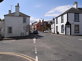
Thornhill is a village in the Mid Nithsdale area of Dumfries and Galloway, Scotland, south of Sanquhar and north of Dumfries on the main A76 road. Thornhill sits in the Nithsdale valley with the Carsphairn and Scaur range to the west and the Lowther hills to the east. It was initially a small village, planned and built in 1717 on the Queensberry Estate on the road linking Dumfries to Glasgow. The Earl of Queensberry initially named the village 'New Dalgarnock' however the name did not achieve popular approval.
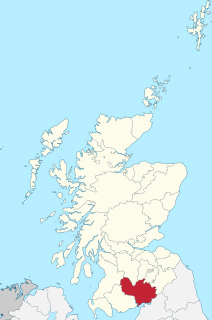
Dumfriesshire or the County of Dumfries is a historic county, registration county and lieutenancy area of southern Scotland.
Penpont is a village about 2 miles (3 km) west of Thornhill in Dumfriesshire, in the Dumfries and Galloway region of Scotland. It is near the confluence of the Shinnel Water and Scaur Water rivers in the foothills of the Southern Uplands. It has a population of about 400 people.

Crichope Linn or Crichop Linn, originally Creehope is a gorge and waterfall near Gatelawbridge in Dumfries and Galloway, southern Scotland. Linn is the Scots language word for waterfall. The etymology of the names 'Cree' or 'Crich' may derive from Gaelic for 'Boundary' and 'Hope' from the Scots for 'a valley among hills,' an apt description.

Closeburn Castle is a tower house, probably of the 14th century, but possibly older, and is one of the oldest continually inhabited houses in Scotland. The castle is located 1 km east of the village of Closeburn, in the historical county of Dumfriesshire, 2 km south-east of Thornhill, in Dumfries and Galloway, Scotland.

Twynholm ( 'TWINE-um') is a village in Scotland. It is located 2+1⁄4 miles (3.6 km) north-northwest of Kirkcudbright and 4+1⁄2 miles (7.2 km) east of Gatehouse of Fleet on the main A75 trunk road. It is in the historic county of Kirkcudbrightshire, Dumfries and Galloway.

Morton Castle is located by an artificial loch in the hills above Nithsdale, in Dumfries and Galloway, south-west Scotland. It lies 2.5 miles (4 km) north-east of Thornhill, and once formed part of a chain of castles along the strategically important Nith Valley, which runs from the Solway Firth north to the Clyde Valley.
Auldgirth is a village on the A76 road in Dumfries and Galloway, Scotland. Auldgirth village features 'The Auldgirth Inn' and the former Auldgirth Primary School, which closed in 2000. Originally inhabitants of Auldgirth located to the scheme, situated next to the A76, but in recent years this has expanded to the outlying areas due to rejuvenation programmes. The name Auldgirth is from Early Scots ald(e) girth, meaning 'old enclosure'. At one time it had a staffed railway station, situated one mile south of the village, just before the hamlet of Dalswinton. Carse Loch and the Friar's Carse country house hotel are located nearby.

Kirkpatrick Durham is a village and parish in the historical county of Kirkcudbrightshire, Dumfries and Galloway, south-west Scotland. It is located 6 miles (9.7 km) north of Castle Douglas.

Durisdeer is a small village in Dumfries and Galloway, south-west Scotland, and in the historic county of Dumfries-shire. It lies 6 miles (9.7 km) north of Thornhill, above the Carron Water, a tributary of the Nith.

Kirkpatrick-Fleming is a village and civil parish in Dumfries and Galloway, south-west Scotland.
Glencairn is an ecclesiastical and civil parish in Dumfries and Galloway, Scotland.
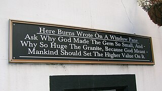
Robert Burns came to know James Cunninghamme, Earl of Glencairn in Edinburgh in 1786 through a 'Letter of Introduction' provided by Dalrymple of Orangefield who was married to Lady Glencairn's sister. The Earl received the poet warmly in his house and introduced him to his friends. One of several gifts from the earl to the poet was a diamond point pen, stylus, or cutter which he used to write upon many windowpanes and glasses, scribing verse, his signature, epigrams, or other writings for posterity. Many of these diamond-point engravings survive, some however are contentious as regards either their authenticity, meaning, or both.

Kirkgunȝeon is a village and civil parish in Dumfries and Galloway, south west Scotland. The village is 10.4 miles (16.7 km) south west of Dumfries and 4.1 miles (6.6 km) north east of Dalbeattie. The civil parish is in the former county of Kirkcudbrightshire, and is bounded by the parishes Lochrutton to the north, Urr to the west, Colvend and Southwick to the south and New Abbey to the east.

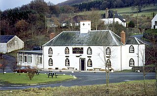
Brownhill Inn, now just called Brownhill, is an inn approximately 1 mile (1.6 km) mile south of Closeburn, on the A76, which itself is about 2 miles (3.2 km) south of Thornhill, in Dumfries and Galloway, Scotland. Built in approximately 1780, this old coaching inn has undergone extensive changes, and only the south side of the original property remains. The inns facilities used to include the once-extensive livery stables on the west side of the road, but these have been sold and converted to farm buildings. The inn was the first changing place for horses hauling coaches from Dumfries and closed in 1850.

Dalgarnock, Dalgarno, Dalgarnoc was an ancient parish and a once considerable sized village in the Nithsdale area of Dumfries and Galloway, Scotland, south of Sanquhar and north of Dumfries that enclosed the parish of Closeburn but was annexed to Closeburn in 1606 following the Reformation, separated again in 1648 and finally re-united in 1697, as part of the process that established the Presbyterian Church of Scotland. It was a burgh of regality bordering the River Nith and Cample Water and held a popular market-tryst or fair from medieval times until 1601 when the Earl of Queensberry had them transferred to Thornhill, commemorated in song by Robert Burns, shortly before its demise and now only a remote churchyard remains at a once busy site.

Enterkinfoot is a small village or hamlet which lies 6 miles (9.7 km) north of Thornhill on the A76 on the route to Sanquhar, in Dumfriesshire, Durisdeer Parish, in Dumfries and Galloway, south-west Scotland. Its original nucleus was the old mill with associated buildings, the school and the famous Enterkin Pass and path that followed the course of the Enterkin Glen to Wanlockhead and from there to Edinburgh. The site features the A76 that runs through the centre of Enterkinfoot, the River Nith and the Enterkin Burn that once powered the mill before joining the Nith. The area is famous for its association with the Covenanters.
Barburgh Mill is a hamlet composed of an old lint mill, later extended as a woollen mill and associated buildings which lies north of Auldgirth on the A76 on the route to Closeburn, in Dumfriesshire, Closeburn Parish, in Dumfries and Galloway, south-west Scotland. Its original nucleus was the old mill with associated buildings, the smithy, toll house and the miller's and workers dwellings. The site features the A76 that runs nearby, the River Nith and the Lake Burn that once powered the mill via a lade before joining the Nith. The area is famous for its association with the Covenanters. A Roman fortlet stood opposite the mill and a Roman road is thought to have run through Nithsdale at this point.

Kirkbride, previously Kilbride was an ancient parish close to the village of Enterkinfoot, the lands of which lay on both sides of the River Nith in the old Strathnith area of Dumfries and Galloway, Scotland, about 5 miles south of Sanquhar and north of Closeburn. The parish was suppressed and divided between Durisdeer and Sanquhar parishes in 1732. The ruins of the kirk are a scheduled monument and the surrounding graveyard is a Category B listed building with the River Nith in the valley below. The Ha Cleuch Burn flows through the glen that lies to the east of the site with a lane reaching it that runs up from Enterkinfoot, ending at Coshogle Farm.

John Bacon was a vintner, the landlord at the one time important hostelry named the Brownhill Inn, that lay in open country to the south of Closeburn in Nithsdale on the Ayr to Dumfries Road. From 1788 to 1791 the poet Robert Burns spent many an evening at Bacon's inn whilst travelling on his Excise duties. A coaching stop and hostelry, the inn lay about 7 miles north of Ellisland Farm, Burns's home before the family moved into Dumfries. During their tour of August–September 1803 Dorothy Wordsworth, with her brother William Wordsworth and mutual friend Samuel Taylor Coleridge were hosted by Bacon and his wife at their inn.
