Applegarthtown

Last updated

Applegarthtown
Dumfries and Galloway UK location map.svg
Red pog.svg
Applegarthtown
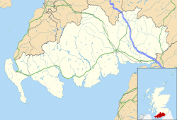
Location within Dumfries and Galloway
OS grid reference NY1084
Council area
Country Scotland
Sovereign state United Kingdom
Police Scotland
Fire Scottish
Ambulance Scottish
List of places
UK
Scotland
55°08′N3°25′W / 55.14°N 03.41°W / 55.14; -03.41 Coordinates: 55°08′N3°25′W / 55.14°N 03.41°W / 55.14; -03.41
The white-painted church at Applegarthtown with the war memorial in the foreground Applegarth church and memorial.jpg
The white-painted church at Applegarthtown with the war memorial in the foreground

Applegarthtown, also known as Applegarth or Applegirth, is a village near Lockerbie in Annandale, Dumfries and Galloway, Scotland.

Applegarth's Town is situated on the east bank of the River Annan close to its junction with the Nethercleugh Burn. it is five kilometres (3.1 mi) west of Lockerbie. [1] The name is derived from the Old Norse and means "apple-yard" or "orchard". Edward I of England offered oblation at a chapel in the parish in 1300 on his way to Caerlaverock. [2]

Applegarth Primary School lies across the A74(M) motorway about three kilometres (1.9 mi) north north east of the village. The primary school was founded by the Jardine family in the 19th century and was renovated and reopened in 1994. [1]

The Jardine chiefs were established at Applegarth by the fourteenth century, [3] The 7th Baronet of Applegirth, Sir William Jardine (1800–1874), was a well known naturalist and geologist. [4] The original seat of the Jardines of Applegarth was at Spedlins Tower, constructed in the 15th century over the site of a previous tower which had been the family seat since the 12th century. [5] In the early 19th Century the family seat was moved across the River Annan to Jardine Hall. [6]

The Applegarthtown Wildlife Sanctuary at nearby Dryfeholm was established in 1984 by converting a piece of low productivity agricultural land into a wetland to attract resident and migratory birds. An artificial sand bank was also created and this was colonised by sand martins. This has allowed scientists to study the breeding behaviour of these birds and has provided an example which has been replicated elsewhere. [7]

Related Research Articles

Inverkeithing Town in Scotland

Inverkeithing is a port town and parish, in Fife, Scotland, on the Firth of Forth. In 2016, the town had an estimated population of 4,890, while the civil parish was reported to have a population of 8,090 in 2011. A town of ancient origin, Inverkeithing was given royal burgh status during the reign of Malcolm IV in the 12th century. It was an important center of trade during the Middle Ages, and its industrial heritage built on quarrying and ship breaking goes back to the 19th century.

Dumfriesshire Historic county in Scotland

Dumfriesshire or the County of Dumfries is a historic county, registration county and lieutenancy area of Scotland.

Sir William Jardine, 7th Baronet Scottish ornithologist and naturalist

Sir William Jardine, 7th Baronet of Applegarth FRS FRSE FLS FSA was a Scottish naturalist. He is known for his editing of a long series of natural history books, The Naturalist's Library.

Point Calimere Wildlife and Bird Sanctuary

Point Calimere Wildlife and Bird Sanctuary (PCWBS) is a 21.47-square-kilometre (8.29 sq mi) protected area in Tamil Nadu, South India along the Palk Strait where it meets the Bay of Bengal at Point Calimere at the southeastern tip of Nagapattinam District. The sanctuary was created in 1967 for conservation of the least concern blackbuck antelope, an endemic mammal species of India. It is famous for large congregations of waterbirds, especially greater flamingos. International name: Point Calimere Wildlife Sanctuary, IBA Code: IN275, Criteria: A1, A4i, A4iii. The 7-square-kilometre (2.7 sq mi) core area of this sanctuary has been proposed as a National Park

Maybole Human settlement in Scotland

Maybole is a town and former burgh of barony and police burgh in South Ayrshire, Scotland. It had an estimated population of 4,610 in 2016. It is situated 9 miles (14 km) south of Ayr and 50 miles (80 km) southwest of Glasgow by the Glasgow and South Western Railway.

Annan, Dumfries and Galloway Human settlement in Scotland

Annan is a town and former royal burgh in Dumfries and Galloway, south-west Scotland. Historically part of Dumfriesshire, its public buildings include Annan Academy, of which the writer Thomas Carlyle was a pupil, and a Georgian building now known as "Bridge House". The Town Hall was built in Victorian style in 1878, using the local sandstone. Annan also features a Historic Resources Centre. In Port Street, some of the windows remain blocked up to avoid paying the window tax.

Pencaitland Village in East Lothian, Scotland

Pencaitland is a village in East Lothian, Scotland, about 12 miles south-east of Edinburgh, 5 mi (8 km) south-west of Haddington, and 1 mi (2 km) east of Ormiston.

Lochmaben Human settlement in Scotland

Lochmaben is a small town and civil parish in Scotland, and site of a castle. It lies 4 miles (6 km) west of Lockerbie, in Dumfries and Galloway.

Bridge of Earn Human settlement in Scotland

Bridge of Earn is a small town in Perthshire, Scotland. Often referred to simply as 'The Brig'. The village grew up on the south bank of an important crossing of the River Earn, whose sandstone bridge existed from at least the early 14th century, when it is known to have been repaired by order of King Robert I of Scotland (1306–1329). Substantial remains of the medieval bridge survived into the 1970s, when almost all the stonework was demolished, for (allegedly) being in a dangerously ruinous condition. This ancient bridge was a major landmark on the road between Edinburgh and Perth for several centuries. The village's oldest houses are to be found lining the road leading south from the site of the demolished bridge. Among them are some with 18th-century datestones.

Newton Wamphray Human settlement in Scotland

Newton Wamphray is a village in Dumfries and Galloway. Wamphray is the name of the surrounding parish and of the Wamphray Water, which flows south-west through the Wamphray Glen to join the River Annan near the small village, or hamlet, of Newton.

Clan Jardine Lowland Scottish clan

Clan Jardine is a Lowland Scottish clan.

Cummertrees Human settlement in Scotland

Cummertrees is a coastal village and civil parish of Annandale in the historical county of Dumfriesshire in Dumfries and Galloway. It lies about 1 mile (1.6 km) inland, on the Pow Water, 12 miles (19 km) from Dumfries and 3 miles (5 km) from Annan.

Longforgan is a village and parish in the Carse of Gowrie, in Perth and Kinross, Scotland. It lies 5 miles west of Dundee on the main A90 road.

Islands of the Forth Group of islands in the Firth of Forth, Scotland

The Islands of the Forth are a group of small islands located in the Firth of Forth and in the estuary of the River Forth on the east coast of Scotland. Most of the group lie in the open waters of the firth, between the Lothians and Fife, with the majority to the east of the city of Edinburgh. Two islands lie further west in the river estuary.

Lockerbie Town in Scotland

Lockerbie is a small town in Dumfries and Galloway, south-western Scotland. It lies approximately 120 kilometres from Glasgow, and 25 km (16 mi) from the border with England. It had a population of 4,009 at the 2001 census. The town came to international attention in December 1988 when the wreckage of Pan Am Flight 103 crashed there following a terrorist bomb attack aboard the flight.

Annandale Way

The Annandale Way is a 90-kilometre (56 mi) hiking trail in Scotland, which is officially designated by NatureScot as one of Scotland's Great Trails. It follows the valley of the River Annan from its source in the Moffat Hills to the sea in the Solway Firth south of the town of Annan. The route, which was established on 12 September 2009, has been designed to be traversable in four to five days as a continuous walk but it also offers several day-walks. Overnight stops can be arranged in small market towns and villages along the route such as Moffat, Johnstonebridge, Lochmaben, Lockerbie, or Annan. The route has been developed by Sulwath Connections and local communities, with the support of local estates and farmers, to help promote Annandale as a new area for walking. Its trailheads are near the Devil's Beef Tub in the Moffat Hills and on the Solway Firth just south of Annan, in Newbie.

Robert Jardine

Sir Robert Jardine, 1st Baronet was a Scottish businessman and Liberal politician

Cummertrees railway station

Cummertrees railway station was a railway station in Dumfries and Galloway south of Dumfries, serving the village of Cummertrees. The village lies some 3 miles (4.8 km) west of Annan and 12 miles (19 km) south of Lockerbie.

Hoddom Castle

Hoddom Castle is a large tower house in Dumfries and Galloway, south Scotland. It is located by the River Annan, 4 kilometres (2.5 mi) south-west of Ecclefechan and the same distance north-west of Brydekirk in the parish of Cummertrees. The castle is protected as a category A listed building.

Nethercleugh railway station was a station which served the rural area around Nethercleugh and the estate of Jardine Hall, 3 miles north of Lockerbie in Applegarth parish, Scottish county of Dumfries and Galloway. It was served by local trains on what is now known as the West Coast Main Line. The nearest station for Nethercleugh is now at Lockerbie.

References

  1. 1 2 "Applegarthtown (Applegarth Town)". Gazetteer for Scotland. Retrieved 4 March 2020.
  2. "Applegarth Parish". Gazetteer for Scotland. Retrieved 4 March 2020.
  3. Way, George; Squire, Romily (1994). Collins Scottish Clan & Family Encyclopedia (Foreword by The Rt Hon. The Earl of Elgin KT, Convenor. The Standing Council of Scottish Chiefs). pp. 176–177.
  4. "The Late Sir William Jardine". Nature. 11 (34).
  5. "Spedlins Tower". Gazetteer for Scotland. Retrieved 4 March 2020.
  6. "Jardine Hall". Gazetteer for Scotland. Retrieved 4 March 2020.
  7. "Applegarthtown Wildlife Sanctuary". Visit Scotland. Retrieved 4 March 2020.