Gretna, Dumfries and Galloway

Last updated

Gretna
Dumfries and Galloway UK location map.svg
Red pog.svg
Gretna
Location within Dumfries and Galloway
Population3,110 (mid-2020 est.) [1]
OS grid reference NY320671
Council area
Lieutenancy area
Country Scotland
Sovereign state United Kingdom
Post town GRETNA
Postcode district DG16
Dialling code 01461
Police Scotland
Fire Scottish
Ambulance Scottish
UK Parliament
Scottish Parliament
List of places
UK
Scotland
54°59′38″N3°03′43″W / 54.994°N 3.062°W / 54.994; -3.062

Gretna (Scottish Gaelic : Greatna) is a town in Dumfries and Galloway, Scotland, originally part of the historic county of Dumfriesshire. [2] It is located close to the A74(M) on the border of Scotland and England and near the mouth of the River Esk. [3]

Contents

The town is situated 31 miles (50 kilometres) east-south-east of Dumfries, 8 mi (13 km) east of Annan, 10 mi (16 km) north-west of Carlisle, 88 mi (142 km) south-east of Glasgow and 89+12 mi (144 km) south of Edinburgh.

History

Etymology

Gretna means "(place at the) gravelly hill", from Old English greot "grit" (in the dative form greoten (which is where the -n comes from) and hoh "hill-spur".

The Lochmaben Stone is a megalith standing in a field, nearly 1 mile (2 km) west of the Sark mouth on the Solway Firth, three hundred yards or so above high water mark on the farm of Old Graitney. It was one of the traditionally recognised meeting places on the England / Scotland border.

17th century

Prior to the Acts of Union 1707 of the Parliaments of England and Scotland, Gretna was a customs post for collecting taxes on cattle crossing the border between the two kingdoms. The Gretna customs post was established in 1612. [4] A drove road was constructed between Gretna and Annan in 1619, possibly to facilitate the transportation of cattle from Wigtownshire, Kirkcudbrightshire and Dumfriesshire to markets in England. [5]

18th century

Gretna's principal claim to fame arose in 1753 when an Act of Parliament, Lord Hardwicke's Marriage Act , was passed in England, which provided, among other things, that if both parties to a marriage were not at least 21 years old, consent to the marriage had to be given by the parents. This Act did not apply in Scotland, which allowed boys to marry at 14 and girls at 12, with or without parental consent. In addition, the Act required procedures that gave notice of an impending marriage to the community. As a result, many elopers fled England, and the first Scottish village they reached was often Gretna. The act was repealed in 1849.

World War I

HM Factory, Gretna, codenamed Moorside, was a cordite munitions factory built between Gretna Green and the Solway Firth to supply ammunition to British forces during World War I. This developed into the town of Gretna.

21st Century

In February 2018, American rapper Playboi Carti was arrested for punching a driver during a concert tour. He was fined £800 after trial.

Transport

Rail

In the 1840s, there were three main railway companies building lines around Gretna and this resulted in three railway stations named "Gretna". The first station called "Gretna" was opened by the Glasgow, Dumfries and Carlisle Railway on 23 August 1843, this station was renamed Gretna Green railway station in April 1852. [6] It closed on 6 December 1965, but a new station was opened by British Rail nearby on 20 September 1993, the station is served by Glasgow South Western Line. [6] This station had a new platform added in 2009,to coincide with the redoubling of this section of track. The other two stations were located a short distance to the east of Gretna, over the border in England. Gretna (Caledonian) railway station was opened on 9 September 1847 by the Caledonian Railway on its main line between Carlisle and Glasgow and Edinburgh. [6] The station closed on 10 September 1951. [6] The North British Railway built Gretna (Border Union) railway station next to the Caledonian station, at Gretna junction, on its short link to the Border Union Railway. The station opened on 1 November 1861 and closed during World War One on 9 August 1915. [6]

Roads

A military road was built in 1763 by General Wade linking Gretna to Portpatrick, then the main ferry port to Northern Ireland. [7] This was later to become the route of much of the A75 road to Stranraer. The original route between Gretna and Annan is now the B721 road, and the A75 diverges significantly from it; similarly, the B724 was the original route between Annan and Dumfries. [8]

The main Anglo-Scottish trunk road running north–south through Gretna was the A74 road. With the opening of the M6 motorway to the south of Carlisle in December 1970, [9] most of the A74 in Scotland was upgraded to motorway, these upgraded sections were renamed the A74(M). The Cumberland Gap was the remaining six miles (ten kilometres) of non-upgraded dual-carriageway A74 between the northern terminus of the M6 at Carlisle.

In 2008, the six remaining miles were upgraded to a three-lane motorway.

Sport

Gretna was the official home of Gretna Football Club, who played in the Scottish Premier League during the 2007–2008 season. A reformed club, Gretna F.C. 2008 is based in Gretna.

AFC Gretna are the town's amateur football team who like to give local players a chance. The club, based in the nearby Springfield, played in the DSAFL. However, they now play in the Carlisle City Sunday League system.

Border Towns United are another amateur football team in the town formed in 2022. The club also play in the Carlisle City Sunday League system in the same league as AFC Gretna. They play at the Graitney.

Gretna Green

Nearby Gretna Green, is traditionally associated with eloping English couples because of the more liberal marriage provisions in Scots law compared to English law. Because of this, "Gretna" has become a term for a place for quick, easy marriages. [10]

Shopping

Gretna Gateway Outlet Village is a shopping centre on the east side of Gretna. In 2021, this was renamed Caledonia Park.

Related Research Articles

<span class="mw-page-title-main">Solway Firth</span> Firth that forms part of the border between England and Scotland

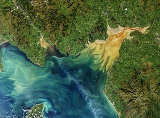
The Solway Firth is a firth that forms part of the border between England and Scotland, between Cumbria and Dumfries and Galloway. It stretches from St Bees Head, just south of Whitehaven in Cumbria, to the Mull of Galloway, on the western end of Dumfries and Galloway. The Isle of Man is also very near to the firth. The firth comprises part of the Irish Sea.

<span class="mw-page-title-main">Dumfries and Galloway</span> Council area of Scotland

Dumfries and Galloway is one of 32 unitary council areas of Scotland and is located in the western Southern Uplands. It covers the historic counties of Dumfriesshire, Kirkcudbrightshire, and Wigtownshire, the latter two of which are collectively known as Galloway. The administrative centre and largest settlement is the town of Dumfries. The second largest town is Stranraer, on the North Channel coast, some 76 miles (122 km) to the west of Dumfries.

<span class="mw-page-title-main">Gretna Green</span> Human settlement in Scotland

Gretna Green is a parish in the southern council area of Dumfries and Galloway, Scotland, on the Scottish side of the border between Scotland and England, defined by the small river Sark, which flows into the nearby Solway Firth. It was historically the first village a traveller would come to in Scotland when following the old coaching route from London to Edinburgh. Gretna Green railway station serves both Gretna Green and Gretna. The Quintinshill rail disaster, the worst rail crash in British history, in which over 220 died, occurred near Gretna Green in 1915.

<span class="mw-page-title-main">A74(M) and M74 motorways</span> Major motorway in Scotland

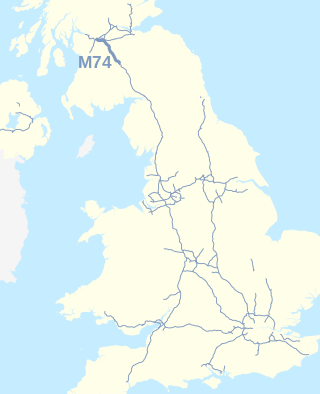
The A74(M) and M74 form a major motorway in Scotland, connecting it to England. The routes connect the M8 motorway in central Glasgow to the Scottish-English border at Gretna. In conjunction with their southward continuation, the M6 motorway, they form one of the three major cross-border routes between Scotland and England. They are part of the unsigned international E-road network E05. Although the entire route is colloquially referred to as the M74, for more than half its length, south of Abington, the road is officially the A74(M); see naming confusion below.

<span class="mw-page-title-main">Dumfriesshire</span> Historic county in Scotland

Dumfriesshire or the County of Dumfries or Shire of Dumfries is a historic county and registration county in southern Scotland. The Dumfries lieutenancy area covers a similar area to the historic county.

<span class="mw-page-title-main">A75 road</span> Road in Scotland

The A75 is a primary trunk road in Scotland, linking Stranraer and its ferry ports at Cairnryan with the A74(M) at Gretna, close to the border with England and the M6 motorway.

<span class="mw-page-title-main">A74 road</span> Road in Scotland

The A74 also known historically as the Glasgow to Carlisle Road, is a formerly major road in the United Kingdom, linking Glasgow in Scotland to Carlisle in the North West of England, passing through Clydesdale, Annandale and the Southern Uplands. A road in this area has existed since Roman Britain, and it was considered one of the most important roads in Scotland, being used as a regular mail service route.

<span class="mw-page-title-main">Southern Uplands</span> Southernmost and least populous region of Scotland

The Southern Uplands are the southernmost and least populous of mainland Scotland's three major geographic areas. The term is used both to describe the geographical region and to collectively denote the various ranges of hills and mountains within this region. An overwhelmingly rural and agricultural region, the Southern Uplands are partly forested and contain many areas of open moorland - the hill names in the area are congruent with these characteristics.

<span class="mw-page-title-main">Annan, Dumfries and Galloway</span> Human settlement in Scotland

Annan is a town and former royal burgh in Dumfries and Galloway, south-west Scotland. Historically part of Dumfriesshire, its public buildings include Annan Academy, of which the writer Thomas Carlyle was a pupil, and a Georgian building now known as "Bridge House". Annan also features a Historic Resources Centre. In Port Street, some of the windows remain blocked up to avoid paying the window tax.

The Glasgow, Dumfries and Carlisle Railway was a railway company in Scotland, which constructed the line from near Cumnock to Gretna Junction, forming the route from Glasgow to Carlisle via Dumfries, in association with other lines. Its promoters hoped it would form the only railway between central Scotland and England, but it lost out to rival companies.

<span class="mw-page-title-main">Glasgow South Western Line</span> Railway line in the UK

The Glasgow South Western Line is a mainline railway in Scotland that runs from Glasgow to Kilmarnock, and then either Carlisle via Dumfries, or Stranraer via Ayr, with a branch to East Kilbride.

<span class="mw-page-title-main">Gretna Green railway station</span> Railway station in Dumfries and Galloway, Scotland

Gretna Green is a railway station on the Glasgow South Western Line, which runs between Carlisle and Glasgow Central via Kilmarnock. The station, situated 9 miles 58 chains (16 km) north-west of Carlisle, serves the town of Gretna and village of Gretna Green in Dumfries and Galloway, Scotland. It is owned by Network Rail and managed by ScotRail.

<span class="mw-page-title-main">Annan railway station</span> Railway station in Dumfries and Galloway, Scotland

Annan is a railway station on the Glasgow South Western Line, which runs between Carlisle and Glasgow Central via Kilmarnock. The station, situated 17 miles 51 chains (28 km) north-west of Carlisle, serves the town of Annan in Dumfries and Galloway, Scotland. It is owned by Network Rail and managed by ScotRail.

Eastriggs is a small village located in Dumfries and Galloway in the south of Scotland, the village is located around 2 mi (3.2 km) north of the mud and sandbanks of the channel of the River Eden, which extends west into the Solway Firth.

<span class="mw-page-title-main">Cummertrees</span> Human settlement in Scotland

Cummertrees is a coastal village and civil parish of Annandale in the historical county of Dumfriesshire in Dumfries and Galloway. It lies about 1 mile (1.6 km) inland, on the Pow Water to the northwest of Powfoot, 12 miles (19 km) from Dumfries and 3 miles (5 km) from Annan.

<span class="mw-page-title-main">Caledonian main line</span> Former railway line in Scotland

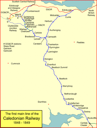
The Caledonian Railway main line in Scotland connected Glasgow and Edinburgh with Carlisle, via Carstairs and Beattock.

<span class="mw-page-title-main">Solway Junction Railway</span> Former railway line in Scotland

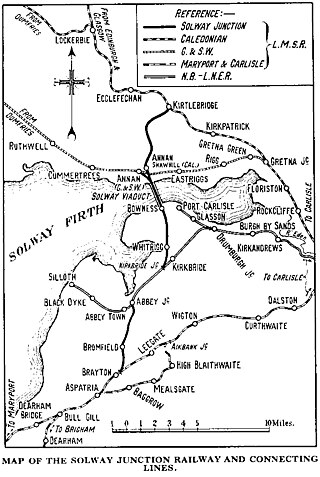
The Solway Junction Railway was built by an independent railway company to shorten the route from ironstone mines in Cumberland to ironworks in Lanarkshire and Ayrshire.

<span class="mw-page-title-main">Annan Shawhill railway station</span> Disused railway station in Dumfries and Galloway, Scotland

Annan Shawhill was a station on the Solway Junction Railway at Annan in Dumfries and Galloway, Scotland. The branch line ran between a junction with the Caledonian Railway Main Line at Kirtlebridge, across the Glasgow South Western Line, over the Solway Viaduct into Cumberland, England. The station opened for passenger services in 1870. Passenger services were withdrawn in the early 1930s when the cost of maintaining the Solway Viaduct was deemed too high to sustain. Although the line to England was removed, the Scottish part of the branch to Annan Shawhill remained opened for freight until it was finally closed in the 1950s.

<span class="mw-page-title-main">Kirkpatrick-Fleming</span>

Kirkpatrick-Fleming is a village and civil parish in Dumfries and Galloway, south-west Scotland.

<span class="mw-page-title-main">Kirtle Water</span>

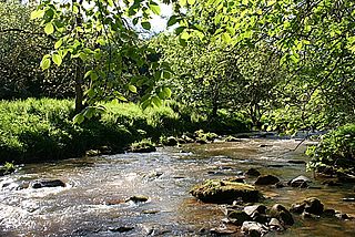
The Kirtle Water is a river in Dumfries and Galloway in southern Scotland. It rises on the southern slopes of Haggy Hill where its headwaters are impounded to form Winterhope Reservoir. Below the dam it flows in a generally southerly direction passing Waterbeck and Eaglesfield to the village of Kirtlebridge along which stretch it is closely followed both by the A74(M) motorway and the mainline railway between Carlisle and Glasgow. From Kirtlebridge it turns southeastwards to flow by Kirkpatrick-Fleming and on, to the west of Gretna, to empty into the estuary of the Border Esk at the eastern limit of the Solway Firth.

References

Notes

  1. "Mid-2020 Population Estimates for Settlements and Localities in Scotland". National Records of Scotland. 31 March 2022. Retrieved 31 March 2022.
  2. Thomson Atlas of Scotland, 1832
  3. 1:50,000 OS map 85
  4. Haldane, pages 161 & 167.
  5. Haldane, pages 31 & 161.
  6. 1 2 3 4 5 Butt, page 110
  7. Taylor, Christopher (1979). The Roads & Tracks of Britain. London, Toronto and Melbourne: J. M. Dent & sons ltd. ISBN   0-460-04329-3, Page 171.
  8. See for instance the re-scaled 1:50,000 Cassini Historical Maps, number 85, for Carlisle & Solway Firth, Revised New Series 19011904 ( ISBN   978-1-84736-369-5) and Popular Edition 1925 ( ISBN   978-1-84736-210-0).
  9. Chatsworth, Table 7.3, pages 100–123.
  10. E.g., State v. Clay, 182 Md. 639, 642, 35 A.2d 821, 822-23 (1944).

Sources