Death Valley is a desert valley in Eastern California, in the northern Mojave Desert, bordering the Great Basin Desert. It is thought to be the hottest place on Earth during summer. Death Valley is home to the Timbisha tribe of Native Americans, formerly known as the Panamint Shoshone, who have inhabited the valley for at least the past millennium.

Kingsbury is a census-designated place (CDP) in Douglas County, Nevada, United States. The population was 2,152 at the 2010 census.

Elko is the largest city in and county seat of Elko County, Nevada, United States. With a 2020 population of 20,564, Elko is currently growing at a rate of 0.31% annually and its population has increased by 11.86% since the 2010 Census, which recorded a population of 18,297. Elko serves as the economic hub of the Ruby Valley, a region with a population of over 55,000. Elko is 21 miles (34 km) from Lamoille Canyon and the Ruby Mountains, dubbed the Swiss Alps of Nevada, providing year round access to recreation including hiking, skiing, hunting, and more than 20 alpine lakes. The city straddles the Humboldt River. Most of the residents in Elko live within the Tree Streets, houses lined with trees and greenery. Spring Creek, Nevada, serves as a bedroom community 6 miles (9.7 km) from the city with a population of 13,805.

Winnemucca is the only incorporated city in, and is the county seat of, Humboldt County, Nevada, United States. As of the 2020 census, the city had a total population of 8,431, up 14.0 percent from the 2010 census figure of 7,396. Interstate 80 passes through the city, where it meets U.S. Route 95.

Battle Mountain is an unincorporated town in and the county seat of Lander County, Nevada, United States. The population was 3,635 at the 2010 census. Its primary economic base is gold mining and, to a lesser extent, legalized gambling.
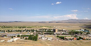
Jackpot is an unincorporated community and census-designated place (CDP) in Elko County, Nevada, United States. The population was 855 as of the 2020 census. Located less than one mile (1.6 km) from the Idaho border on US 93, Jackpot has been a popular casino gaming destination for residents of Idaho and other neighboring states since its founding.

The following table lists the highest and lowest temperatures recorded in the 50 U.S. states, the District of Columbia, and the 5 inhabited U.S. territories during the past two centuries, in both Fahrenheit and Celsius. If two dates have the same temperature record, only the most recent date is shown.

Eureka is an unincorporated town and census-designated places in and the county seat of Eureka County, Nevada, United States. With a population of 480 as of the 2018 American Community Survey 5-Year Estimates, it is by far the largest community in Eureka County. Attractions include the Eureka Opera House, Raine’s Market and Wildlife Museum, the Jackson House Hotel, and the Eureka Sentinel Museum.

Jarbidge is an unincorporated community in Elko County, Nevada, United States. Located at the bottom of the Jarbidge River's canyon near the north end of the Jarbidge Mountains, it lies within the Jarbidge Ranger District of the Humboldt-Toiyabe National Forest and is near the northwest edge of the Jarbidge Wilderness, approximately 10 miles (16 km) south of the Idaho–Nevada border.

Mercury is a closed village in Nye County, Nevada, United States, 5 miles (8.0 km) north of U.S. Route 95 at a point 65 miles (105 km) northwest of Las Vegas. It is situated within the Nevada National Security Site and was constructed by the Atomic Energy Commission to house and service the staff of the test site. The specific site was known as Jackass Flats and nearby Nevada Test Site 400. Today, the site is governed by the United States Department of Energy. As part of the test site, the village is not accessible to the general public. It was named after the mercury mines which flourished in its general vicinity a century before the village itself was established. The current population is unknown.

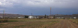
Orovada is a census-designated place in Humboldt County, Nevada. The population was 155 at the 2010 census.

San Jacinto is a ghost town in along Salmon Falls Creek in northern Elko County, Nevada, United States. It is part of the Elko Micropolitan Statistical Area.

The climate of California varies widely from hot desert to alpine tundra, depending on latitude, elevation, and proximity to the Pacific Coast. California's coastal regions, the Sierra Nevada foothills, and much of the Central Valley have a Mediterranean climate, with warmer, drier weather in summer and cooler, wetter weather in winter. The influence of the ocean generally moderates temperature extremes, creating warmer winters and substantially cooler summers in coastal areas.
Isabella is a remote unincorporated community in Stony River Township, Lake County, Minnesota, United States.

The landlocked U.S. state of Nevada has a varied geography and is almost entirely within the Basin and Range Province and is broken up by many north–south mountain ranges. Most of these ranges have endorheic valleys between them.

Arizona is a landlocked state situated in the southwestern region of the United States of America. It has a vast and diverse geography famous for its deep canyons, high- and low-elevation deserts, numerous natural rock formations, and volcanic mountain ranges. Arizona shares land borders with Utah to the north, the Mexican state of Sonora to the south, New Mexico to the east, and Nevada to the northwest, as well as water borders with California and the Mexican state of Baja California to the southwest along the Colorado River. Arizona is also one of the Four Corners states and is diagonally adjacent to Colorado.

Wild Horse Reservoir is a man-made lake in Elko County, Nevada in the United States. The reservoir was initially created in 1937 by the construction of Wild Horse Dam. In 1969, a new concrete single-angle arch dam was constructed by the United States Bureau of Reclamation for the Bureau of Indian Affairs with a height of 87 feet (27 m) and a length of 458 feet (140 m) at its crest. The original 1937 dam was left in place and is still partly visible. The newer dam doubled the size of the reservoir.
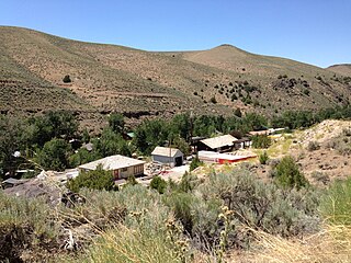
Murphy Hot Springs is an unincorporated community in Owyhee County, Idaho, United States. It is located along Three Creek Road between Rogerson, Idaho and Jarbidge, Nevada at the bottom of the East Fork Jarbidge River's canyon. As of 2007, the community contains approximately 50 homes.
The 2018 North American heat wave affected regions of Canada, where at least 70 deaths in Quebec were heat-related, the United States, where 18 states between Michigan and New Mexico issued heat advisories to a population of over 60 million people, and of Mexico, particularly the northwest and central regions.