
Willershausen is a village in the Northeim District, Lower Saxony, and part of the Kalefeld municipality.
Willershausen is a village in the Northeim District, Lower Saxony, and part of the Kalefeld municipality.
The village was first mentioned in a deed from 1294. Throughout the Middle Ages the Fulda monastery held fief rights in Willershausen village, so that in modern times a cross symbolising Fulda was integrated in the coat of arms of Willershausen village. Village inhabitants worked as farmers and in a brickyard, too. That brickyard was founded in the 16th century and shut down in 1977.
The raw material of the brickyard was clay which stemmed from a nearby Open-pit mining site. By about 1920, fossils were discovered there. Research was conducted by geologists and paleontologists of the University of Göttingen. The clay site was geologically formed in the pliocene epoch. [1] Mining was stopped when the brickyard shut down. [2] Among the fossils that were found are parts of Mammutidae, Giant salamander, fishes and ostracods, too. Calosoma sycophanta was among the insect fossils of the site. [3] A single Comptonia fossil was found, too, which was unique in Europe. A Comptonia leaf was thus integrated in the coat of arms of Willershausen village.
The former clay mine is a landmark of the Harz – Brunswick Land – Eastphalia National Geopark since 2012. It is a natural monument, too. In a local showroom examples of fossas from that clay site are exhibited.
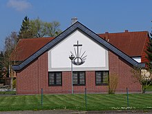
The local Lutheran church was built in 1750 and is devoted to Pope Alexander I. The parish is part of Evangelical-Lutheran Church of Hanover. Its rectory was built in 1865 with plans of Conrad Wilhelm Hase.
A New Apostolic Church building was built in 1992.

Lower Saxony is a German state (Land) situated in northwestern Germany. It is the second-largest state by land area, with 47,624 km2 (18,388 sq mi), and fourth-largest in population among the 16 Länder federated as the Federal Republic of Germany. In rural areas, Northern Low Saxon and Saterland Frisian are still spoken, albeit in declining numbers.

Salzgitter is an independent city in southeast Lower Saxony, Germany, located between Hildesheim and Braunschweig. Together with Wolfsburg and Braunschweig, Salzgitter is one of the seven Oberzentren of Lower Saxony. With 101,079 inhabitants and 223.92 square kilometres (86.46 sq mi), its area is the largest in Lower Saxony and one of the largest in Germany. Salzgitter originated as a conglomeration of several small towns and villages, and is today made up of 31 boroughs, which are relatively compact conurbations with wide stretches of open country between them. The main shopping street of the young city is in the borough of Lebenstedt, and the central business district is in the borough of Salzgitter-Bad. The city is connected to the Mittellandkanal and the Elbe Lateral Canal by a distributary. The nearest metropolises are Braunschweig, about 23 kilometres to the northeast, and Hanover, about 51 km to the northwest. The population of the City of Salzgitter has exceeded 100,000 inhabitants since its foundation in 1942, when it was still called Watenstedt-Salzgitter. Beside Wolfsburg, Leverkusen and Eisenhüttenstadt, Salzgitter is one of the few cities in Germany founded during the 20th century.

The Harz is a highland area in northern Germany. It has the highest elevations for that region, and its rugged terrain extends across parts of Lower Saxony, Saxony-Anhalt, and Thuringia. The name Harz derives from the Middle High German word Hardt or Hart, Latinized as Hercynia. The Brocken is the highest summit in the Harz with an elevation of 1,141.1 metres (3,744 ft) above sea level. The Wurmberg is the highest peak located entirely within the state of Lower Saxony.

Goslar is a historic town in Lower Saxony, Germany. It is the administrative centre of the district of Goslar and located on the northwestern slopes of the Harz mountain range. The Old Town of Goslar and the Mines of Rammelsberg are UNESCO World Heritage Sites for their millenium-long testimony to the history of ore mining and their political importance for the Holy Roman Empire and Hanseatic League. Each year Goslar awards the Kaiserring to an international artist, called the "Nobel Prize" of the art world.

The Rammelsberg is a mountain, 635 metres (2,083 ft) high, on the northern edge of the Harz range, south of the historic town of Goslar in the North German state of Lower Saxony. The mountain is the location of an important silver, copper, and lead mine, the only mine which had been working continuously for over 1,000 years when it finally closed in 1988. Because of its long history of mining and testimony to the advancement and exchange of technology over many centuries, the visitor mine of Rammelsberg was inscribed as a UNESCO World Heritage Site in 1992.
Bad Harzburg is a spa town in central Germany, in the Goslar district of Lower Saxony. It lies on the northern edge of the Harz mountains and is a recognised saltwater spa and climatic health resort.
Kreiensen is a village and a former municipality in the district of Northeim, in Lower Saxony, Germany. Since 1 January 2013, it is part of the town Einbeck.
Wildemann is a town and a former municipality in the district of Goslar, in Lower Saxony, Germany. It has been part of the town Clausthal-Zellerfeld since January 1, 2015. It is situated in the west of the Harz, northwest of Clausthal-Zellerfeld. It was part of the former Samtgemeinde Oberharz.

Altenau is a town and a former municipality in the district of Goslar, in Lower Saxony, Germany. Since 1 January 2015 it is part of the town Clausthal-Zellerfeld.

Stolberg (help·info) is a town and a former municipality in the district of Mansfeld-Südharz, in the German State of Saxony-Anhalt, Germany. It is situated in the southern part of the Harz mountains, about 27 kilometres (17 mi) west of Sangerhausen, and 13 km (8.1 mi) northeast of Nordhausen. Since 1 September 2010, it has been part of the municipality of Südharz.

Walkenried Abbey was a Cistercian abbey located in the village of Walkenried in Lower Saxony, Germany. Founded in 1127 on the southern rim of the Harz mountain range, the remnants of the monastic complex since 2010 are part of the Upper Harz Water Regale World Heritage Site.
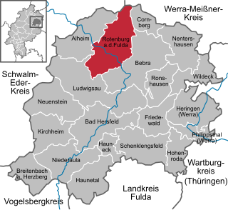
Rotenburg an der Fulda is a town in Hersfeld-Rotenburg district in northeastern Hesse, Germany lying, as the name says, on the river Fulda.

Schierke is a village and a former municipality in the Harz district, in the German state of Saxony-Anhalt. Since 1 July 2009, it is part of the town Wernigerode. Situated within the Harz mountain range in the valley of the river Bode, at the rim of the Harz National Park, it is mainly a tourist resort, especially for hiking and all kinds of winter sports.

Schulenberg im Oberharz is a village and a former municipality in the district of Goslar in Lower Saxony, Germany. It has been part of the town Clausthal-Zellerfeld since January 1, 2015.
Wulften am Harz is a municipality in Lower Saxony, Germany, near the towns of Northeim and Osterode am Harz.

The Upper Harz refers to the northwestern and higher part of the Harz mountain range in Germany. The exact boundaries of this geographical region may be defined differently depending on the context. In its traditional sense, the term Upper Harz covers the area of the seven historical mining towns (Bergstädte) - Clausthal, Zellerfeld, Andreasberg, Altenau, Lautenthal, Wildemann and Grund - in the present-day German federal state of Lower Saxony. Orographically, it comprises the Harz catchment areas of the Söse, Innerste and Grane, Oker and Abzucht mountain streams, all part of the larger Weser watershed.
Silberhütte is a village in the town of Harzgerode in the district of Harz in the German state of Saxony-Anhalt. Its name means "silver works", a place where silver ore is smelted.
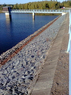
The Kiliansteich is one of the oldest reservoirs in Germany. The reservoir is located near Straßberg (Harz) in the German state of Saxony-Anhalt and supplies drinking water. It impounds the Büschengraben stream. The lake is part of the heritage area (Flächendenkmal) of the Lower Harz Pond and Ditch System.

Within the Lower Harz region are still many traces of the historical water management facilities used by the mining industry. In addition to water-carrying ditches and ponds, there are also long-abandoned ditches and dry pond beds. The Lower Harz Pond and Ditch System, which forms the major part of these old water management facilities, lies in the central Lower Harz, almost entirely within the borough of the present-day town of Harzgerode.
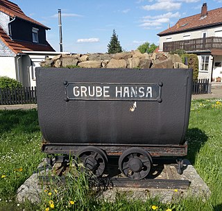
The Hansa Pit was a mine on the territory of Harlingerode in the county of Wolfenbüttel in the Free State of Brunswick and later in Lower Saxony, West Germany. It was founded on the Langenberg south of Harlingerode; however, the only remainders are located on the north side.
| General | |
|---|---|
| National libraries | |