William Bean

Last updated

William Bean
William Bean Cabin Placque.jpg
Tennessee Historical Commission marker placed near the William Bean Cabin site in present-day Johnson City
Born
William Bean

(1721-12-09)December 9, 1721
DiedMay 1782 (aged 60)
Bean's Station, Tennessee
Nationality American
Occupation(s) Longhunter, soldier, pioneer, politician
Known forbeing the reported first permanent European-American settler, and founding the first permanent European-American settlement of Tennessee [1]
TitleCommissioner, Watauga Association [2]
Term1772-April 1775
PredecessorOffice established
SuccessorOffice dissolved
Spouse
Lydia Russell
(m. 1744;died 1788)
Children6
Parents
  • William Bean (father)
  • Margaret Hatton Bean (mother)

William Bean (December 9, 1721-May 1782) was an American pioneer, longhunter, and Commissioner of the Watauga Association. He is accepted by historians as the first permanent European American settler of Tennessee. [3]

Contents

Biography

William Bean was born December 9, 1721. In 1744, Bean married Lydia Russell of Northumberland County. [4] William was of Scottish descent, and Lydia was of English descent. [5]

Settlement in the Watauga Association

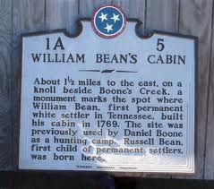
In 1762, Bean set camp close to the junction of Boone's Creek and the Watauga River, near present-day Johnson City during a longhunting excursion with fellow pioneers and friends Daniel Boone and Richard Callaway, on behalf of Richard Henderson, a land surveyor who played an important role in the early settlement of Tennessee. [6] [7] In 1769, he constructed a cabin at this site and relocate his family. Shortly after the cabin's completion, Lydia Bean gave birth to a son, Russell Bean, who would be historically accepted as the first European American born in present-day Tennessee. [8] The Bean family encountered aggressive confrontations with the inhabiting Cherokee tribes, and found distaste in the growing popularity of the Watauga Association. Nevertheless, William Bean pursued a career in politics and be elected as a commissioner of the Watauga Association in 1772, serving a crucial role in the absorption of the settlement into the state of North Carolina by 1775. [2]

American Revolution and establishment of Bean Station

The view of the German Creek valley as seen from Clinch Mountain East Tennessee Crossing - The Lakes of the Crossing from Clinch Mountain - NARA - 7718101.jpg
The view of the German Creek valley as seen from Clinch Mountain

In 1775, William Bean collaborated with Daniel Boone on a new longhunting excursion, as Bean wanted to move west with the Watauga Association gaining popularity, and Boone was wanting to expand his Wilderness Road southward towards the Great Indian Warpath. The duo crossed the gap on top of Clinch Mountain after traversing the Powell and Clinch rivers in present-day Claiborne and Grainger counties in Tennessee. After surveying the valley below, Bean and Boone descended the southward slope of Clinch Mountain and set camp along the German Creek tributary of the Holston River and the Great Indian Warpath. Finding appreciation for the vast wildlife, timber, fertile soil, and access to navigable waters, Bean chose this site as the permanent site of his new home and to establish a community with Boone planning to extend the Wilderness Road to the campsite location. [9]

During the Revolutionary War, Bean served as a captain for the Virginia militia, and was awarded over 3,000 acres in the German Creek valley where he surveyed and camped at previously with Boone in 1776. In the same year, Bean constructed a four-room cabin with the assistance of his sons. The cabin served as his family's home, and as an inn for prospective settlers, fur traders, and longhunters, named Bean Station, establishing the first reportedly permanent settled community in present-day Tennessee. [1]

In 1780, Bean served in his position of captain in the Battle of Kings Mountain. [2]

Death and legacy

In May 1782, Bean died of unknown causes at the age of 60 in his cabin at Bean Station. [2]

Bean’s settlement of Bean Station grew substantially following his death in 1782. By 1787, Bean’s sons constructed a fort, blacksmiths shop, and a trading outpost at the community’s crossroads of the Wilderness Road and the Great Indian Warpath. [9] [10]

Bean Station emerged as an important stopover, due to its strategic location on the crossroads of present day U.S. Route 25E and U.S. Route 11W, between Washington, D.C., and New Orleans for early travelers through Tennessee into the 18th century. [11] [12]

The town and cabin established by Bean were lost following the flooding of the Holston River valley for the construction of the Cherokee Dam by the Tennessee Valley Authority in 1942. Bean Station unofficially relocated to the new crossroads of US 25E and US 11W, and incorporated into a town in 1996. [13]

Related Research Articles

<span class="mw-page-title-main">Grainger County, Tennessee</span> County in Tennessee, United States

Grainger County is a county located in the U.S. state of Tennessee. As of the 2020 census, the population was 23,527. Its county seat is Rutledge. Grainger County is a part of both the Knoxville Metropolitan Statistical Area and Morristown Metropolitan Statistical Area.

<span class="mw-page-title-main">Blaine, Tennessee</span> Knoxville suburb and city in Grainger County, Tennessee

Blaine, formerly known as Blaine's Crossroads, is a city in Grainger County, Tennessee, United States, and a suburb of neighboring Knoxville. It is part of both the Knoxville Metropolitan Statistical Area and the Morristown Metropolitan Statistical Area. The population was 2,084 at the 2020 census.

<span class="mw-page-title-main">Rutledge, Tennessee</span> City in Tennessee, United States

Rutledge is a city in and the county seat of Grainger County, Tennessee. The city is part of both the Knoxville metropolitan area and the Morristown metropolitan area. As of the 2020 census, the city had a total population of 1,321.

<span class="mw-page-title-main">Watauga River</span> River in the United States of America

The Watauga River is a large stream of western North Carolina and East Tennessee. It is 78.5 miles (126.3 km) long with its headwaters in Linville Gap to the South Fork Holston River at Boone Lake.

<span class="mw-page-title-main">Wilderness Road</span> Historic highway in Kentucky, US

The Wilderness Road was one of two principal routes used by colonial and early national era settlers to reach Kentucky from the East. Although this road goes through the Cumberland Gap into southern Kentucky and northern Tennessee, the other is sometimes called the "Cumberland Road" because it started in Fort Cumberland in Maryland. Despite Kentucky Senator Henry Clay's advocacy of this route, early in the 19th century, the northern route was selected for the National Road, connecting near Washington, Pennsylvania into the Ohio Valley of northern Kentucky and Ohio.

<span class="mw-page-title-main">Bean Station, Tennessee</span> Lakeside town in Grainger and Hawkins counties, Tennessee

Bean Station is a town in Grainger and Hawkins counties in the state of Tennessee, United States. As of the 2020 census, the population was 2,967. It is part of the Kingsport Metropolitan Statistical Area, Knoxville Metropolitan Statistical Area, and Morristown metropolitan statistical area. Established in 1776 as a frontier outpost by pioneer William Bean, it is considered one of the earliest permanently settled communities in Tennessee. It grew throughout the rest of the 18th and 19th centuries as an important stopover for early pioneers and settlers in the Appalachia region due to its strategic location at the crossroads of Daniel Boone's Wilderness Road and the Great Indian Warpath.

<span class="mw-page-title-main">U.S. Route 11W</span> Suffixed section of U.S. Highway in Tennessee and Virginia in the United States

U.S. Route 11W (US 11W) is the western branch of US 11 from the twin cities of Bristol, Tennessee/Bristol, Virginia, where US 11 splits into US 11E and US 11W, to Knoxville, Tennessee, where the two highways rejoin. The highway serves the Appalachia region's Ridge-and-Valley section of East Tennessee, bounded by the Clinch Mountain ridge to the north and the Holston River to the south. US 11W from Bristol to Bean Station and Blaine to Knoxville are designated as part of the National Highway System.

<span class="mw-page-title-main">U.S. Route 25E</span> Highway in Tennessee and Kentucky, United States

U.S. Route 25E (US 25E) is the eastern branch of US 25 from Newport, Tennessee, where US 25 splits into US 25E and US 25W, to North Corbin, Kentucky, where the two highways rejoin. The highway, however, continues as US 25E for roughly two miles (3.2 km) until it joins Interstate 75 (I-75) in the Laurel County community of North Corbin at exit 29. The highway serves the Appalachia regions of Kentucky's Cumberland Plateau and the Ridge-and-Valley section of East Tennessee, including the urbanized areas of Corbin and Middlesboro in Kentucky and Morristown in Tennessee.

<span class="mw-page-title-main">Sycamore Shoals</span> River rapids along the Watauga River in Elizabethton, Tennessee, US

The Sycamore Shoals of the Watauga River, usually shortened to Sycamore Shoals, is a rocky stretch of river rapids along the Watauga River in Elizabethton, Tennessee. Archeological excavations have found Native Americans lived near the shoals since prehistoric times, and Cherokees gathered there. As Europeans began settling the Trans-Appalachian frontier, the shoals proved strategic militarily, as well as shaped the economies of Tennessee and Kentucky. Today, the shoals are protected as a National Historic Landmark and are maintained as part of Sycamore Shoals State Historic Park.

<span class="mw-page-title-main">Clinch Mountain</span> Mountain ridge in Tennessee and Virginia, United States

Clinch Mountain is a mountain ridge in the U.S. states of Tennessee and Virginia, lying in the ridge-and-valley section of the Appalachian Mountains. From its southern terminus at Kitts Point, which lies at the intersection of Knox, Union and Grainger counties near Blaine, Tennessee, it runs in a generally east-northeasterly direction to Garden Mountain near Burke's Garden, Virginia. It separates the Clinch River basin to the north and the Holston River basin to the south.

<span class="mw-page-title-main">Longhunter</span> Frontier hunters in Kentucky and Tennessee

A longhunter was an 18th-century explorer and hunter who made expeditions into the American frontier for as much as six months at a time.

<span class="mw-page-title-main">Sycamore Shoals State Historic Area</span> State park in Elizabethton, Tennessee, USA

Sycamore Shoals State Historic Area is a state park located in Elizabethton, in the U.S. state of Tennessee. The park consists of 70 acres (28.3 ha) situated along the Sycamore Shoals of the Watauga River, a National Historic Landmark where a series of events critical to the establishment of the states of Tennessee and Kentucky, and the settlement of the Trans-Appalachian frontier in general, took place. Along with the historic shoals, the park includes a visitor center and museum, the reconstructed Fort Watauga, the Carter House and Sabine Hill . For over a thousand years before the arrival of European explorers, Sycamore Shoals and adjacent lands had been inhabited by Native Americans. The first permanent European settlers arrived in 1770, and established the Watauga Association—one of the first written constitutional governments west of the Appalachian Mountains—in 1772. Richard Henderson and Daniel Boone negotiated the Treaty of Sycamore Shoals in 1775, which saw the sale of millions of acres of Cherokee lands in Kentucky and Tennessee and led to the building of the Wilderness Road. During the American Revolution, Sycamore Shoals was both the site of Fort Watauga, where part of a Cherokee invasion was thwarted in 1776, and the mustering ground for the Overmountain Men in 1780.

<span class="mw-page-title-main">Cherokee Lake</span> Artificial reservoir in East Tennessee, United States

Cherokee Lake, also known as Cherokee Reservoir, is an artificial reservoir in the U.S. state of Tennessee formed by the impoundment of the Holston River behind Cherokee Dam.

<span class="mw-page-title-main">Joppa, Tennessee</span> Unincorporated community in Tennessee, United States

Joppa is an unincorporated community in rural central-western Grainger County, Tennessee, United States. It rests below Joppa Mountain, a subrange located near the southern terminus of the 150 mile (240 km) long Clinch Mountain ridge complex, offering views of five U.S. States and the Great Smoky Mountains. Joppa is part of the Morristown, Tennessee Metropolitan Statistical Area, and also a component of the Knoxville-Morristown-Sevierville Combined Statistical Area.

<span class="mw-page-title-main">Thorn Hill, Tennessee</span> Unincorporated town in Tennessee, United States

Thorn Hill is an unincorporated community in rural northeastern Grainger County, Tennessee. It is part of the Morristown Metropolitan Statistical Area which consists of Grainger, Hamblen, and Jefferson counties.

Arcadia is an unincorporated community located in Sullivan County, Tennessee, just outside Kingsport's eastern city limits. Arcadia, originally known as the Reedy Creek Settlement, was one of the earliest settlements in present-day Tennessee. Daniel Boone's Wilderness Road ran through this community in 1775. Arcadia is listed in the National Register of Historic Places which includes the Thomas Fain Plantation. Thomas Fain named his plantation "Arcadia" to which the surrounding community became known. Arcadia is part of the Kingsport–Bristol (TN)–Bristol (VA) Metropolitan Statistical Area, which is a component of the Johnson City–Kingsport–Bristol, TN-VA Combined Statistical Area – commonly known as the Tri-Cities region.

<span class="mw-page-title-main">Path Grant Deed</span>

The Path Grant Deed is a document regarded as a first step toward the American westward migration across the Appalachian Mountains, resulting from negotiations at Sycamore Shoals in March 1775. The land acquired within the boundaries of the Path Grant allowed Daniel Boone to develop the Wilderness Road free from attack or claims by the Cherokee. The Path Grant was recorded on November 15, 1794, by the Hawkins County, Tennessee registrar in Deed Book #1, pages 147-151

<span class="mw-page-title-main">Tennessee State Route 32</span> State unsigned highway in Tennessee

State Route 32 is a state highway in East Tennessee. For most of its route, it is an unsigned companion route concurrent with U.S. Route 25E. The highway stretches 89 miles from the North Carolina state line to the Tennessee-Kentucky state line near the town of Cumberland Gap.

<span class="mw-page-title-main">East Tennessee Crossing Byway</span> National Scenic Byway in East Tennessee

The East Tennessee Crossing Byway is a 83-mile (134 km) National Scenic Byway in the U.S. state of Tennessee. Established in 2009, it is one of the newest byways in the National Scenic Byway system. The scenic byway traverses mostly along an unsigned concurrency of U.S. Route 25E/State Route 32 (US 25E/SR 32) in East Tennessee.

<span class="mw-page-title-main">Tate Springs</span> Former resort complex in Bean Station, Tennessee

Tate Springs was a historic world-class luxury resort complex located on U.S. Route 11W in Bean Station, Tennessee, United States. Known for its mineral spring water shipped internationally, it was considered to be one of the most popular resorts of its time in the Southern United States, and was visited by many wealthy and prominent families such as the Ford, Rockefeller, Firestone, Studebaker, and Mellon families.

References

  1. 1 2 Clouse, Allie (May 27, 2021). "From Davy to Dolly: 225 years (and more) of Tennessee's storied history". Knoxville News Sentinel . Retrieved June 1, 2021.
  2. 1 2 3 4 Tuller, Roberta (2020). "William Bean". An American Family History. Retrieved June 1, 2021.
  3. Lambert, A.J. "WILLIAM BEAN, REV'L WAR" (PDF). Retrieved June 30, 2020.
  4. Larry Kraus. "Children of William Bean (c 1700 – 1780) | William Bean I Genealogy". larkcom.us. Retrieved May 14, 2015.
  5. Grady, J.A. (1973). William Bean, Pioneer of Tennessee, and His Descendants. Grady. Retrieved May 14, 2015.
  6. Ramsey, The Annals of Tennessee, 66-69.
  7. Hamer, Tennessee: A History, 64.
  8. "William Bean's Cabin - 1A5 | Tennessee Historical sign". waymarking.com. Retrieved May 14, 2015.
  9. 1 2 Coffey, Ken (October 19, 2012). "The First Family of Tennessee". Grainger County Historic Society. Thomas Daugherty. Archived from the original on March 20, 2018. Retrieved August 20, 2020.
  10. Barksdale, Kevin (July 11, 2014). The Lost State of Franklin: America's First Secession (E-book). University Press of Kentucky. p. 19. ISBN   9780813150093 . Retrieved December 3, 2020.
  11. Brown, Fred (2005). Marking Time (Paperback). University of Tennessee Press. pp. 99–101. ISBN   9781572333307 . Retrieved October 17, 2020.
  12. Lane, Ida M. (December 1, 1929). "Once The Teeming Crossroads Of The Wilderness, Bean Station Now Lapsed Into Village Peace". Knoxville News Sentinel . p. 23. Retrieved November 7, 2020 via Newspapers.com.
  13. Coffey, Ken. "History of Bean Station". Town of Bean Station. Archived from the original on July 24, 2015. Retrieved July 23, 2015.

Further reading