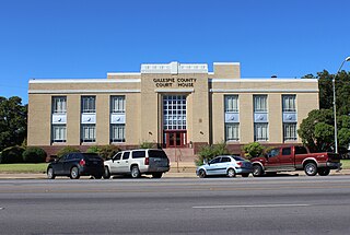
Gillespie County is a county located on the Edwards Plateau in the U.S. state of Texas. As of the 2020 census, its population was 26,725. The county seat is Fredericksburg. It is located in the heart of the rural Texas Hill Country in Central Texas. Gillespie is named for Robert Addison Gillespie, a soldier in the Mexican–American War.

Fredericksburg is a city in, and the seat of, Gillespie County, Texas, United States. As of the 2010 Census, this city had a population of 10,530.

Harper is an unincorporated community and census-designated place (CDP), located 23 miles (37 km) west of Fredericksburg on U.S. Highway 290, in Gillespie County, in the U.S. state of Texas. The population was 1,192 at the 2010 census.
Stonewall is an unincorporated community and census-designated place (CDP) in Gillespie County, Texas, United States. The population was 525 at the 2010 census. It was named for Confederate General Thomas J. (Stonewall) Jackson, by Israel P. Nunez, who established a stage station near the site in 1870.
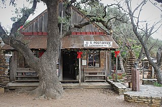
Luckenbach is an unincorporated community 13 miles (19 km) from Fredericksburg in southeastern Gillespie County, Texas, United States. Named for Carl Albert Luckenbach, son of the early settler Jacob Luckenbach, the town is known as a venue for country music and for its German-Texan heritage.
Wadsworth is an unincorporated community in Matagorda County, Texas, United States. According to the Handbook of Texas, the community had an estimated population of 180 in 2000.
Castell is a small unincorporated, rural town in Llano County, Texas, United States. It is part of the Texas German belt region, and most residents are still ethnic German-Texan. Its population was 104 at the 2010 census. Located in the heart of the Texas Hill Country, its northern border is formed by the Llano River. It was designated a Recorded Texas Historic Landmark in 1964, marker number 9440.
Pontotoc is an unincorporated community on Pontotoc Creek, in northeastern Mason County, Texas, United States. The community is located at the junction of State Highway 71 and Ranch to Market Road 501.

Hye is an unincorporated community in western Blanco County, Texas, United States. According to the Handbook of Texas, the community had a population of 105 in 2000. Hye is part of the Texas-German belt and in very conservative rural Texas.

Briggs is an unincorporated community in eastern Burnet County, Texas, United States. It lies along U.S. Route 183 and FM 2657, northeast of Burnet. Its elevation is 1,102 feet (336 m), and it is located at 30°53′23″N97°55′30″W. Although Briggs is unincorporated, it has a post office, with the ZIP code of 78608; the ZCTA for ZIP Code 78608 had a population of 101 at the 2020 census.
Dodge is an unincorporated community in eastern Walker County, Texas, United States, on the northern edge of the Sam Houston National Forest. It lies along FM 405 east of the city of Huntsville, the county seat of Walker County. Its elevation is 400 feet (122 m). Although Dodge is unincorporated, it has a post office, with the ZIP code of 77334; the ZCTA for ZIP Code 77334 had a population of 184 at the 2000 census.
Art is an unincorporated community in Mason County, Texas, United States. According to the Handbook of Texas, the highly-dispersed community had an estimated population of 18 in 2016.

Fischer is an unincorporated community in Comal County, Texas, United States. The population was 688 at the 2010 census. The community is a part of the Texas-German Belt which runs from Schulenburg in the east, and west through the Hill Country to Fredericksburg. Most residents of Fischer have German-Texan ancestry, and the name Fischer is named after Otto and Hermann Fischer, German immigrants.

Cherry Spring is an unincorporated farming and ranching community established in 1852 in Gillespie County, in the U.S. state of Texas. It is located on Cherry Spring Creek, which runs from north of Fredericksburg to Llano. The creek was also sometimes known as Cherry Springs Creek by residents. The community is located on the old Pinta Trail. The Cherry Spring School was added to the National Register of Historic Places Listings in Gillespie County, Texas on May 6, 2005. The school was designated a Recorded Texas Historic Landmark in 1985.

Crabapple is an unincorporated farming and ranching community 10.5 miles (16.9 km) north of Fredericksburg in Gillespie County, Texas, United States, located on Crabapple Creek, about halfway between Fredericksburg and Enchanted Rock State Park at an elevation of 1,775 feet. Crabapple School was designated a Recorded Texas Historic Landmark in 1994, and added to the National Register of Historic Places in Texas on May 6, 2005.
Pedernales was an early settlement of German immigrants in Gillespie County, Texas, United States, and was part of the Adelsverein colonization of Texas. No trace of the settlement remains today. It was located 7 miles (11 km) southwest of Fredericksburg near what is now Texas State Highway 16. The Pedernales school received a Texas Historical Commission Subject Marker in 1993, Marker number 10095.
Eckert is a ghost town, 11.5 miles (18.5 km) northeast of Fredericksburg in Gillespie County, in the U.S. state of Texas. West of Willow City, on FM 1323, Eckert is at the junction of State Highway 16.
The History of Fredericksburg, Texas dates back to its founding in 1846. It was named after Prince Frederick of Prussia. Fredericksburg is also notable as the home of Texas German, a dialect spoken by the first generations of German settlers who initially refused to learn English. Fredericksburg shares many cultural characteristics with New Braunfels, which had been established by Prince Carl of Solms-Braunfels the previous year.

Willow City School is at 2501 Ranch to Market Road 1323 in Gillespie County, in the U.S. state of Texas. It was consolidated with Fredericksburg Independent School District in 1961. The building is now used as a community center. It was added to the National Register of Historic Places listings in Gillespie County, Texas on May 6, 2005.
Sandy is an unincorporated community in Blanco County, in the U.S. state of Texas. According to the Handbook of Texas, the community had a population of 25 in 2000.


