Willow Creek, Montana

Last updated

Willow Creek, Montana
Gallatin County Montana Incorporated and Unincorporated areas Willow Creek Highlighted.svg
Location of Willow Creek, Montana
Coordinates: 45°49′38″N111°38′7″W / 45.82722°N 111.63528°W / 45.82722; -111.63528
Country United States
State Montana
County Gallatin
Area
[1]
  Total2.73 sq mi (7.07 km2)
  Land2.73 sq mi (7.07 km2)
  Water0.00 sq mi (0.00 km2)
Elevation
[2]
4,173 ft (1,272 m)
Population
 (2020)
  Total230
  Density84.28/sq mi (32.54/km2)
Time zone UTC-7 (Mountain (MST))
  Summer (DST) UTC-6 (MDT)
ZIP code
59760
Area code 406
FIPS code 30-80800
GNIS feature ID2409599 [2]

Willow Creek is a census-designated place (CDP) in Gallatin County, Montana, United States. [2] The population was 210 at the 2010 census. [3] It is part of the Bozeman, MT Micropolitan Statistical Area.

Contents

History

The settlement here began in 1864 and soon grew due to a mining boom in nearby Norwegian Gulch. The Northern Pacific Railroad arrived at Willow Creek in 1883. [4]

Geography

Willow Creek is located in western Gallatin County at 45°49′38″N111°38′7″W / 45.82722°N 111.63528°W / 45.82722; -111.63528 (45.827110, -111.635392), [5] where the valley of Willow Creek (the stream) enters the valley of the Jefferson River. It is 6 miles (10 km) southwest of Three Forks and 7 miles (11 km) southwest of Interstate 90.

According to the United States Census Bureau, the CDP has a total area of 2.73 square miles (7.08 km2), all land. [3]

Demographics

Historical population
CensusPop.Note
2020 230
U.S. Decennial Census [6]

As of the census [7] of 2000, there were 209 people, 81 households, and 52 families residing in the CDP. The population density was 192.4 inhabitants per square mile (74.3/km2). There were 84 housing units at an average density of 77.3 per square mile (29.8/km2). The racial makeup of the CDP was 92.34% White, 0.96% Asian, 0.48% Pacific Islander, 3.83% from other races, and 2.39% from two or more races. Hispanic or Latino of any race were 5.26% of the population.

There were 81 households, out of which 34.6% had children under the age of 18 living with them, 54.3% were married couples living together, 4.9% had a female householder with no husband present, and 34.6% were non-families. 30.9% of all households were made up of individuals, and 9.9% had someone living alone who was 65 years of age or older. The average household size was 2.58 and the average family size was 3.23.

In the CDP, the population was spread out, with 31.6% under the age of 18, 8.1% from 18 to 24, 30.6% from 25 to 44, 20.1% from 45 to 64, and 9.6% who were 65 years of age or older. The median age was 34 years. For every 100 females, there were 93.5 males. For every 100 females age 18 and over, there were 101.4 males.

The median income for a household in the CDP was $32,386, and the median income for a family was $32,083. Males had a median income of $25,000 versus $17,500 for females. The per capita income for the CDP was $13,251. About 15.5% of families and 14.0% of the population were below the poverty line, including 20.3% of those under the age of eighteen and 13.3% of those 65 or over.

Education

Willow Creek School educates students from kindergarten through 12th grade. [8] They are known as the Broncs. Willow Creek High School is a Class C school [9] (less than 108 students) which helps determine athletic competitions.

See also

Related Research Articles

<span class="mw-page-title-main">Willow Street, Pennsylvania</span> Census-designated place in Pennsylvania, United States

Willow Street is an unincorporated community and census-designated place (CDP) in Lancaster County, Pennsylvania, United States. The population was 7,578 at the 2010 census. In the early part of the 20th century, the main thoroughfare in town was lined with willow trees on both sides for the length of the town, hence the community's name. As time passed and the town grew, the road was widened and sidewalks were installed, which required the trees be removed. Only a few of the original trees remain to this day.

<span class="mw-page-title-main">Gallatin County, Montana</span> County in Montana, United States

Gallatin County is located in the U.S. state of Montana. With its county seat in Bozeman, it is the second-most populous county in Montana, with a population of 118,960 in the 2020 Census.

<span class="mw-page-title-main">Willow, Alaska</span> CDP in Alaska, United States

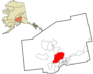
Willow is a census-designated place (CDP) in the Matanuska-Susitna Borough in the U.S. state of Alaska. Located 26 miles northwest from Wasilla along the George Parks Highway, it is part of the Anchorage, Alaska Metropolitan Statistical Area. At the 2020 census the population was 2,196, up from 2,102 in 2010.

Willow Creek is a census-designated place (CDP) in Copper River Census Area, Alaska, United States. At the 2020 census the population was 190, down from 191 in 2010.

<span class="mw-page-title-main">Gisela, Arizona</span> CDP in Gila County, Arizona

Gisela is an unincorporated community and census-designated place (CDP) in Gila County, Arizona, United States. The population was 570 at the 2010 census.

<span class="mw-page-title-main">Three Lakes, Florida</span> Census-designated place in Florida, United States

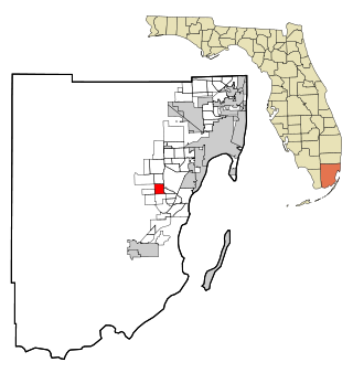
Three Lakes is a census-designated place (CDP) in Miami-Dade County, Florida, United States. The population was 16,540 at the 2020 census, up from 15,047 in 2010. Its name comes from the planned community of Three Lakes, which is located inside Three Lakes CDP boundaries.

<span class="mw-page-title-main">Muddy, Montana</span> Census-designated place in Montana, United States

Muddy or Heóvonėheo'hé'e is a census-designated place (CDP) in Big Horn County, Montana, United States and home to the Heóvonėheo'hé'etaneo'o or Heóvonêheo'he'é-taneno Cheyenne people. The population was 617 at the 2010 census.

<span class="mw-page-title-main">Pryor, Montana</span> Census-designated place in Montana, United States

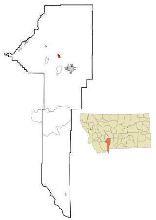
Pryor is a census-designated place (CDP) in Big Horn County, Montana, United States. The community is located on Crow Tribe's reservation. The population was 618 at the 2010 census. The area is named for Nathaniel Hale Pryor, a sergeant in the Lewis and Clark Expedition.

<span class="mw-page-title-main">Radersburg, Montana</span> Census-designated place in Montana, United States

Radersburg is a census-designated place (CDP) in Broadwater County, Montana, United States. The population was 66 at the 2010 census.

<span class="mw-page-title-main">Toston, Montana</span> Census-designated place in Montana, United States

Toston is a census-designated place (CDP) in Broadwater County, Montana, United States. The population was 108 at the 2010 census.

<span class="mw-page-title-main">Fort Shaw, Montana</span> CDP in Montana, United States

Fort Shaw is a census-designated place (CDP) in Cascade County, Montana, United States. The population was 280 at the 2010 census. Named for a former United States military outpost, it is part of the Great Falls, Montana Metropolitan Statistical Area.

<span class="mw-page-title-main">Simms, Montana</span> CDP in Montana, United States

Simms is a census-designated place (CDP) in Cascade County, Montana, United States. The population was 354 at the 2010 census. It is part of the Great Falls, Montana Metropolitan Statistical Area.

<span class="mw-page-title-main">Sun Prairie, Montana</span> CDP in Montana, United States

Sun Prairie is a census-designated place (CDP) in Cascade County, Montana, United States. The population was 1,630 at the 2010 census. It is part of the Great Falls Metropolitan Statistical Area and may have evolved as a remote suburb of Great Falls.

<span class="mw-page-title-main">Ulm, Montana</span> CDP in Montana, United States

Ulm is a census-designated place (CDP) in Cascade County, Montana, United States. It was originally a large ranch owned by Indiana-born cattleman William Ulm. The population was 738 at the 2010 census. It is part of the Great Falls, Montana Metropolitan Statistical Area. The Zip Code is 59485.

<span class="mw-page-title-main">Belgrade, Montana</span> City in Montana, United States

Belgrade is a city in Gallatin County, Montana, United States. The population was 10,460 at the 2020 census. It is the largest city in Montana that is not a county seat.

<span class="mw-page-title-main">Four Corners, Montana</span> Census-designated place in Montana, United States

Four Corners is a census-designated place (CDP) in Gallatin County, Montana, United States. The population was 5,901 at the 2020 census, up from 3,146 in 2010. It is part of the Bozeman, MT Micropolitan Statistical Area.

<span class="mw-page-title-main">Manhattan, Montana</span> Town in Montana, United States

Manhattan is a town in Gallatin County, Montana, United States. The population was 2,086 at the 2020 census. It is part of the 'Bozeman Micropolitan Statistical Area'.

<span class="mw-page-title-main">Helena Valley Northeast, Montana</span> Census-designated place in Montana, United States

Helena Valley Northeast is a census-designated place (CDP) in Lewis and Clark County, Montana, United States. The population was 2,995 at the 2010 census. It is part of the Helena Micropolitan Statistical Area.

<span class="mw-page-title-main">Harrison, Montana</span> Census-designated place in Montana, United States

Harrison is a census-designated place (CDP) in Madison County, Montana, United States. The population was 137 at the 2010 census, down from 162 in 2000.

<span class="mw-page-title-main">Clancy, Montana</span> Census-designated place in Montana, United States

Clancy is an unincorporated community and census-designated place (CDP) in Jefferson County, Montana, United States. The population was 1,661 at the 2010 census, up from 1,406 in 2000. It is part of the Helena Micropolitan Statistical Area.

References

  1. "ArcGIS REST Services Directory". United States Census Bureau. Retrieved September 5, 2022.
  2. 1 2 3 U.S. Geological Survey Geographic Names Information System: Willow Creek, Montana
  3. 1 2 "Geographic Identifiers: 2010 Demographic Profile Data (G001): Willow Creek CDP, Montana". American Factfinder. U.S. Census Bureau. Retrieved December 22, 2016.[ dead link ]
  4. "Willow Creek". Montana Place Names Companion. Montana Historical Society. Retrieved April 11, 2021.
  5. "US Gazetteer files: 2010, 2000, and 1990". United States Census Bureau. February 12, 2011. Retrieved April 23, 2011.
  6. "Census of Population and Housing". Census.gov. Retrieved June 4, 2016.
  7. "U.S. Census website". United States Census Bureau . Retrieved January 31, 2008.
  8. "Willow Creek School". Willow Creek School. Retrieved April 17, 2021.
  9. "Member Schools". Montana High School Association. Retrieved April 19, 2021.

Commons-logo.svg Media related to Willow Creek, Montana at Wikimedia Commons