Four Corners, Montana

Last updated
Four Corners, Montana
Gallatin County Montana Incorporated and Unincorporated areas Four Corners Highlighted.svg
Location of Four Corners, Montana
Coordinates: 45°40′4″N111°10′57″W / 45.66778°N 111.18250°W / 45.66778; -111.18250 Coordinates: 45°40′4″N111°10′57″W / 45.66778°N 111.18250°W / 45.66778; -111.18250
Country United States
State Montana
County Gallatin
Area
[1]
  Total10.91 sq mi (28.25 km2)
  Land10.84 sq mi (28.08 km2)
  Water0.07 sq mi (0.17 km2)
Elevation
[2]
4,718 ft (1,438 m)
Population
 (2020)
  Total5,901
  Density544.22/sq mi (210.12/km2)
Time zone UTC-7 (Mountain (MST))
  Summer (DST) UTC-6 (MDT)
Area code 406
FIPS code 30-28862
GNIS feature ID2408250 [2]

Four Corners is a census-designated place (CDP) in Gallatin County, Montana, United States. The population was 5,901 at the 2020 census, [3] up from 3,146 in 2010. It is part of the Bozeman, MT Micropolitan Statistical Area.

Contents

Geography

Four Corners is located in central Gallatin County at 45°40′4″N111°10′57″W / 45.66778°N 111.18250°W / 45.66778; -111.18250 (45.667876, -111.182530), [4] 7 miles (11 km) west of Bozeman. The "Four Corners" refers to the intersection of U.S. Route 191, Montana Highway 84 and Montana Highway 85. US 191 leads east to Bozeman and south 82 miles (132 km) to West Yellowstone, MT 84 leads west 29 miles (47 km) to Norris, and MT 85 leads north 9 miles (14 km) to Belgrade and Interstate 90.

According to the United States Census Bureau, the Four Corners CDP has a total area of 10.84 square miles (28.07 km2). [3] The Gallatin River, a north-flowing tributary of the Missouri River, forms the western edge of the CDP.

Demographics

Historical population
CensusPop.Note
2020 5,901
U.S. Decennial Census [5]

As of the census [6] of 2000, there were 1,828 people, 761 households, and 506 families residing in the CDP. The population density was 178.4 inhabitants per square mile (68.9/km2). There were 795 housing units at an average density of 77.6 per square mile (30.0/km2). The racial makeup of the CDP was 97.43% White, 0.16% African American, 0.55% Native American, 0.49% Asian, 0.16% Pacific Islander, 0.27% from other races, and 0.93% from two or more races. Hispanic or Latino of any race were 0.98% of the population.

There were 761 households, out of which 30.1% had children under the age of 18 living with them, 55.6% were married couples living together, 7.0% had a female householder with no husband present, and 33.5% were non-families. 24.7% of all households were made up of individuals, and 5.8% had someone living alone who was 65 years of age or older. The average household size was 2.40 and the average family size was 2.87.

In the CDP, the population was spread out, with 23.0% under the age of 18, 10.1% from 18 to 24, 31.3% from 25 to 44, 25.7% from 45 to 64, and 9.9% who were 65 years of age or older. The median age was 37 years. For every 100 females, there were 112.1 males. For every 100 females age 18 and over, there were 113.2 males.

The median income for a household in the CDP was $36,964, and the median income for a family was $43,977. Males had a median income of $30,710 versus $21,146 for females. The per capita income for the CDP was $18,185. About 8.1% of families and 10.3% of the population were below the poverty threshold, including 12.7% of those under age 18 and 12.3% of those age 65 or over.

See also

Related Research Articles

<span class="mw-page-title-main">Park County, Montana</span> County in Montana, United States

Park County is a county in the U.S. state of Montana. At the 2020 census, the population was 17,191. Its county seat is Livingston. A small part of Yellowstone National Park is in the southern part of the county.

<span class="mw-page-title-main">Meagher County, Montana</span> County in Montana, United States

Meagher County is a county located in the U.S. state of Montana. As of the 2020 census, the population was 1,927. Its county seat is White Sulphur Springs.

<span class="mw-page-title-main">Madison County, Montana</span> County in Montana, United States

Madison County is a county in the U.S. state of Montana. As of the 2020 census, the population was 8,623. Its county seat is Virginia City. The county was founded in 1865; at the time it was part of the Montana Territory.

<span class="mw-page-title-main">Gallatin County, Montana</span> County in Montana, United States

Gallatin County is located in the U.S. state of Montana. With its county seat in Bozeman, it is the second-most populous county in Montana, with a population of 118,960 in the 2020 Census.

<span class="mw-page-title-main">Broadwater County, Montana</span> County in Montana, United States

Broadwater County is a county in the U.S. state of Montana. As of the 2020 census, the population was 6,774. Its county seat is Townsend. The county was named for Charles Arthur Broadwater, a noted Montana railroad, real estate, and banking magnate.

<span class="mw-page-title-main">Mount Vernon, Maryland</span> CDP in Maryland, United States

Mount Vernon is a census-designated place (CDP) in Somerset County, Maryland, United States. The population was 761 at the 2000 census. It is included in the Salisbury, Maryland-Delaware Metropolitan Statistical Area.

<span class="mw-page-title-main">Sun Prairie, Montana</span> CDP in Montana, United States

Sun Prairie is a census-designated place (CDP) in Cascade County, Montana, United States. The population was 1,630 at the 2010 census. It is part of the Great Falls Metropolitan Statistical Area and may have evolved as a remote suburb of Great Falls.

<span class="mw-page-title-main">Hungry Horse, Montana</span> Unincorporated community in Montana, United States

Hungry Horse is an unincorporated community and census-designated place (CDP) in Flathead County, Montana, United States. The population was 828 at the 2020 census. The ZIP code for Hungry Horse is 59919.

<span class="mw-page-title-main">Belgrade, Montana</span> City in Montana, United States

Belgrade is a city in Gallatin County, Montana, United States. The population was 10,460 at the 2020 census. It is the largest city in Montana that is not a county seat.

<span class="mw-page-title-main">Bozeman, Montana</span> City in Montana, United States

Bozeman is a city and the county seat of Gallatin County, Montana, United States. Located in southwest Montana, the 2020 census put Bozeman's population at 53,293 making it the fourth-largest city in Montana. It is the principal city of the Bozeman, MT Micropolitan Statistical Area, consisting of all of Gallatin County with a population of 118,960. It is the largest micropolitan statistical area in Montana, the fastest growing micropolitan statistical area in the United States in 2018, 2019 and 2020, as well as the second-largest of all Montana's statistical areas.

<span class="mw-page-title-main">Manhattan, Montana</span> Town in Montana, United States

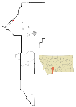
Manhattan is a town in Gallatin County, Montana, United States. The population was 2,086 at the 2020 census. It is part of the 'Bozeman Micropolitan Statistical Area'.

<span class="mw-page-title-main">Three Forks, Montana</span> City in Montana, United States

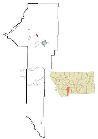
Three Forks is a city in Gallatin County, Montana, United States and is located within the watershed valley system of both the Missouri and Mississippi rivers drainage basins — and is historically considered the birthplace or start of the Missouri River. The population was 1,989 at the 2020 census. The city of Three Forks is named so because it lies geographically near the point, in nearby Missouri Headwaters State Park, where the Jefferson, Madison, and Gallatin rivers converge to form the Missouri River — the longest single river in North America, as well as the major portion of the Missouri–Mississippi River System from the headwaters near Three Forks to its discharge into the Gulf of Mexico. Three Forks is part of the Bozeman, MT Micropolitan Statistical Area of approximately 100,000 people and located thirty miles west of Bozeman.

<span class="mw-page-title-main">Willow Creek, Montana</span> Census-designated place in Gallatin County, Montana, United States.

Willow Creek is a census-designated place (CDP) in Gallatin County, Montana, United States. The population was 210 at the 2010 census. It is part of the Bozeman, MT Micropolitan Statistical Area.

<span class="mw-page-title-main">Big Arm, Montana</span> Census-designated place in Montana, United States

Big Arm is a census-designated place (CDP) in Lake County, Montana, United States. The population was 177 at the 2010 census, up from 131 in 2000.

<span class="mw-page-title-main">Ravalli, Montana</span> Census-designated place in Montana, United States

Ravalli is an unincorporated community and census-designated place (CDP) in Lake County, Montana, United States. The population was 76 at the 2010 census, down from 119 in 2000. At one time Charlie Allard, the country's leading expert on breeding bison, owned the country's largest herd of buffalo in Ravalli.

<span class="mw-page-title-main">Rocky Point, Montana</span> Census-designated place in Montana, United States

Rocky Point is a census-designated place (CDP) in Lake County, Montana, United States. The population was 97 at the 2010 census.

<span class="mw-page-title-main">Harrison, Montana</span> Census-designated place in Montana, United States

Harrison is a census-designated place (CDP) in Madison County, Montana, United States. The population was 137 at the 2010 census, down from 162 in 2000.

<span class="mw-page-title-main">Cardwell, Montana</span> Census-designated place in Montana, United States

Cardwell is a census-designated place (CDP) in Jefferson County, Montana, United States. The population was 50 at the 2010 census. It is part of the Helena Micropolitan Statistical Area.

<span class="mw-page-title-main">Clancy, Montana</span> Census-designated place in Montana, United States

Clancy is an unincorporated community and census-designated place (CDP) in Jefferson County, Montana, United States. The population was 1,661 at the 2010 census, up from 1,406 in 2000. It is part of the Helena Micropolitan Statistical Area.

<span class="mw-page-title-main">Power, Montana</span> CDP in Montana, United States

Power is a census-designated place (CDP) in Teton County, Montana, United States. The population was 171 at the 2000 census. The town is named after Montana pioneer, Thomas Charles Power, who platted the townsite in 1910.

References

  1. "ArcGIS REST Services Directory". United States Census Bureau. Retrieved September 5, 2022.
  2. 1 2 U.S. Geological Survey Geographic Names Information System: Four Corners, Montana
  3. 1 2 "Four Corners CDP, Montana". Census.gov. Retrieved 13 April 2023.
  4. "US Gazetteer files: 2010, 2000, and 1990". United States Census Bureau. 2011-02-12. Retrieved 2011-04-23.
  5. "Census of Population and Housing". Census.gov. Retrieved June 4, 2016.
  6. "U.S. Census website". United States Census Bureau . Retrieved 2008-01-31.

Commons-logo.svg Media related to Four Corners, Montana at Wikimedia Commons