Related Research Articles
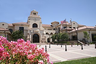
Temecula is a city in southwestern Riverside County, California, United States. The city had a population of 110,003 as of the 2020 census and was incorporated on December 1, 1989. The city is a tourist and resort destination, with the Temecula Valley Wine Country, Old Town Temecula, the Temecula Valley Balloon & Wine Festival, the Temecula Valley International Film Festival, championship golf courses, and resort accommodations contributing to the city's economic profile.

Warner's Ranch, near Warner Springs, California, was notable as a way station for large numbers of emigrants on the Southern Emigrant Trail from 1849 to 1861, as it was a stop on both the Gila River Trail and the Butterfield Overland Mail stagecoach line (1859-1861). It was also operated as a pioneering cattle ranch.
Temecula Creek, formerly known as the Temecula River, runs 32.6 miles (52.5 km) through southern Riverside County, California, United States, past the rural communities of Radec and Aguanga, and ending 0.5 miles (0.80 km) southeast of the original city center of Temecula. The creek is filled with boulders and is typically dry and sandy. It is a relatively undeveloped coastal-draining watershed. Until the 1920s, water flowed in Temecula Creek year-round.
Warner Springs is set of springs and a small unincorporated community in northern San Diego County, California. Warner Springs is on the Pacific Crest Trail.
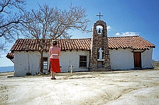
Juan José Warner (1807–1890), a naturalized American-Mexican citizen, developed Warner's Ranch in Warner Springs, California. From 1849 to 1861, the ranch was important as a stop for emigrant travelers on the Southern Emigrant Trail, including the Gila River Emigrant Trail and the Butterfield Overland Mail stagecoach line. Warner established the only trading post between New Mexico and Los Angeles. Warner's Ranch was designated a National Historic Landmark.
Rancho La Laguna was a 13,339-acre (53.98 km2) Mexican land grant in present-day Riverside County, California given in 1844 by Governor Manuel Micheltorena to Julian Manriquez. The rancho lands are included in the present day city of Lake Elsinore and Wildomar. At the time of the US Patent, Rancho Laguna was a part of San Diego County. The County of Riverside was created by the California Legislature in 1893 by taking land from both San Bernardino and San Diego Counties.
Rancho Little Temecula was a 2,233-acre (9.04 km2) Mexican land grant in present-day Riverside County, California given in 1845 by Governor Pío Pico to Pablo Apis. The grant was one of the few held by indigenous people. The grant is south of present-day Temecula and is bordered on the north by Temecula Creek. At the time of the US patent, Rancho Little Temecula was a part of San Diego County. Riverside County was created by the California Legislature in 1893 by taking land from both San Bernardino and San Diego Counties.
Rancho Temecula was a 26,609-acre (107.68 km2) Mexican land grant in present-day Riverside County, California given on December 14, 1844 by Governor Manuel Micheltorena to Feliz Valdez. The grant extended south along the east bank Murrieta Creek to Temecula Creek and encompassed present-day Temecula, Murrieta and Murrieta Hot Springs. At the time of the US patent, Rancho Temecula was a part of San Diego County. Riverside County was created by the California Legislature in 1893 by taking land from both San Bernardino and San Diego Counties.
Rancho Pauba was a 26,598-acre (107.64 km2) Mexican land grant in present-day Riverside County, California given in 1844 by Governor Manuel Micheltorena to Vicente Moraga and Luis Arenas. The grant was just east of present-day Temecula. At the time of the US patent, Rancho Pauba was a part of San Diego County. Riverside County was created by the California Legislature in 1893 by taking land from both San Bernardino and San Diego Counties.

Rancho Temescal was a farming outpost of Mission San Luis Rey de Francia, one of the 21 Franciscan missions established in California by Spain during the late 18th and early 19th centuries. The Mission was located on the coast where Oceanside, California is today. The Rancho was settled in 1819 by Leandro Serrano, and became the first non-native settlement within the boundaries of what would become Riverside County, California.
The Butterfield Overland Mail in California was created by the United States Congress on March 3, 1857, and operated until June 30, 1861. Subsequently, other stage lines operated along the route until the Southern Pacific Railroad arrived in Yuma, Arizona in 1877.

Southern Emigrant Trail, also known as the Gila Trail, the Kearny Trail, Southern Trail and the Butterfield Stage Trail, was a major land route for immigration into California from the eastern United States that followed the Santa Fe Trail to New Mexico during the California Gold Rush. Unlike the more northern routes, pioneer wagons could travel year round, mountain passes not being blocked by snows, however it had the disadvantage of summer heat and lack of water in the desert regions through which it passed in New Mexico Territory and the Colorado Desert of California. Subsequently, it was a route of travel and commerce between the eastern United States and California. Many herds of cattle and sheep were driven along this route and it was followed by the San Antonio-San Diego Mail Line in 1857–1858 and then the Butterfield Overland Mail from 1858–1861.
The San Antonio–San Diego Mail Line, also known as the Jackass Mail, was the earliest overland stagecoach and mail operation from the Eastern United States to California in operation between 1857 and 1861. It was created, organized and financed by James E. Birch the head of the California Stage Company. Birch was awarded the first contract for overland service on the "Southern Route", designated Route 8076. This contract required a semi-monthly service in four-horse coaches, scheduled to leave San Antonio and San Diego on the ninth and the 24th of each month, with 30 days allowed for each trip.
The Butterfield Overland Mail was a transport and mail delivery system that employed stagecoaches that travelled on a specific route between St. Louis, Missouri and San Francisco, California and which passed through the New Mexico Territory. It was created by the United States Congress on March 3, 1857, and operated until March 30, 1861. The route that was operated extended from where the ferry across the Colorado River to Fort Yuma Station, California was located, through New Mexico Territory via, Tucson to the Rio Grande and Mesilla, New Mexico then south to Franklin, Texas, midpoint on the route. The New Mexico Territory mail route was divided into two divisions each under a superintendent. Tucson was the headquarters of the 3rd Division of the Butterfield Overland Mail Company. Franklin Station in the town of Franklin,, was the headquarters of the 4th Division.
El Camino Viejo a Los Ángeles, also known as El Camino Viejo and the Old Los Angeles Trail, was the oldest north-south trail in the interior of Spanish colonial Las Californias (1769–1822) and Mexican Alta California (1822–1848), present day California. It became a well established inland route, and an alternative to the coastal El Camino Real trail used since the 1770s in the period.
Tejon Creek, originally in Spanish Arroyo de Tejon, is a stream in Kern County, California. Its headwaters are located on the western slopes of the Tehachapi Mountains, and it flows northwest into the southern San Joaquin Valley.
King's Station, also known as Moore's and Hollandsville, was a stagecoach station of the Butterfield Overland Mail 1st Division between 1858-1861 in southern California.
The Butterfield Overland Mail route in Baja California was created as a result of an act by the United States Congress on March 3, 1857, and operated until June 30, 1861 as part of the Second Division of the route. Subsequently other stage lines operated along the route until the Southern Pacific Railroad arrived in Yuma, Arizona.
Linda Rosa, or Linda Rose, is a former populated place, formerly in San Diego County, now in Riverside County, California. The town site of Linda Rosa was located southwest of the old town of Murrieta, California on the west side of Murrieta Creek. Linda Rosa is a name derived from Spanish meaning "pretty rose".
Murrieta Creek runs 13 miles (21 km) southeasterly through southwestern Riverside County, California, United States, through the cities of Wildomar, Murrieta, and Temecula, ending 0.5 miles (0.80 km) southeast of the city center of Temecula, where it has its confluence with Temecula Creek and forms the head of the Santa Margarita River.
References
- 1 2 Lech, Steve (2012). Pioneers of Riverside County: The Spanish, Mexican and Early American Periods. Charleston, SC: The History Press. p. 88. ISBN 978-1609498313. OCLC 814373331.
- ↑ Benjamin Ignatius Hayes, Pioneer notes from the diaries of Judge Benjamin Hayes, 1849–1875, Edited and published by Marjorie Tisdale Wolcott, Los Angeles, 1929, pp. 220-221
- ↑ The "pass of Temecula mountain" is now traversed by Rainbow Valley Boulevard between Temecula and Rainbow, California.
- ↑ Congressional edition Volume 3583, War of the Rebellion, Series I vol. L in two Parts. Part I – Reports and Correspondence, Etc., Government Printing Office, Washington, 1897. p. 1111, Report to Headquarters Department of the Pacific from Assistant Adjutant General, Lt. Col. Richard C. Drum, May 20, 1862
- ↑ Report of the Surveyor General 1844–1886
Coordinates: 33°31′37″N117°10′21″W / 33.52694°N 117.17250°W