Winnemucca Lake

Last updated
Winnemucca Lake
Relief map of U.S., Nevada.png
Red pog.svg
Winnemucca Lake
Winnemucca Lake
Coordinates 40°06′40″N119°20′28″W / 40.111°N 119.341°W / 40.111; -119.341
Surface elevation3,770 ft (1,150 m)
Winnemucca Lake bed, blue lake to the left is Pyramid Lake Winnemucca Lake (213008212).jpg
Winnemucca Lake bed, blue lake to the left is Pyramid Lake
Petroglyph site 26 Wa 3329, with some of the oldest known petroglyphs in the Americas Tufa petroglyph site.jpg
Petroglyph site 26 Wa 3329, with some of the oldest known petroglyphs in the Americas
Detail of Petroglyphs - the carvings can be dated because they were covered by tufa layers, after the water level rose above them DSCN0858.JPG
Detail of Petroglyphs – the carvings can be dated because they were covered by tufa layers, after the water level rose above them

Winnemucca Lake is a dry lake bed in northwest Nevada that features the oldest known petroglyphs in North America. Located astride the border between Washoe and Pershing counties, [1] it was a shallow lake until the 1930s, but was dried when a dam and a road were built that combined to restrict and block water flow. It was formerly designated as a National Wildlife Refuge, but its status as a refuge was removed due to the lack of water.

Contents

Winnemucca Lake is home to several petroglyphs long believed to be very old. In 2013, researchers dated the carvings to between 14,800 and 10,500 years ago. Either date would make them the oldest known petroglyphs found in North America. The carvings lie within the Pyramid Lake Indian Reservation.

Note: There is another lake, having the same name of "Winnemucca Lake" in California, near the Carson pass (coordinates: 38°40'10.80"N, 119°59'36.59"W, google map link: https://goo.gl/maps/79RHE2cNwEwNC2WB9).

Geography

Winnemucca Lake is a sub-basin within the Lahontan Basin in northwestern Nevada. [2] It lies east of Pyramid Lake and is on the dividing line between Washoe and Pershing counties. The lake bed lies between the Lake Range on the west and the Nightingale Mountains and Selenite Range to the east. Winnemucca Lake is about 45 km (28 mi) long and about 7 km (4.3 mi) wide. The lake bed is at an elevation of 1,150 m (3,770 ft), [3] [4] which is below the water level of adjacent Pyramid Lake. [5]

History

Winnemucca Lake may have been dry when John Frémont came through in 1843–44. [6] [7] [8] Frémont's 1844 map indicates that he traveled to the west of Winnemucca Lake and does not map the Winnemucca Lake valley. [9] The Elko Free Press reports that there was a flood in 1862 that filled the lake to 80 feet (24 m), but Russell states that the level was low in 1862. [10]

In 1865, Winnemucca Lake (then known as Mud Lake) was the site of the Battle of Mud Lake where 29 soldiers from the 1st Nevada Volunteer Cavalry Battalion led by Captain Almond B. Wells (and two civilian guides) killed 29 Smoke Creek Indians. At least two of those killed were women, possibly more. Sarah Winnemucca wrote "I had one baby brother killed there. My sister jumped on father's best horse and ran away. As she ran the soldiers ran after her but thanks be to the Good Father in the Spirit land my dear sister got away. This almost killed my poor papa." [11]

The maximum level of the lake was 26 meters (85 ft) in the 1880s [7]

Winnemucca Lake was a shallow tule-filled lake and an important stop for migrating waterfowl. After the Derby Dam was built on the Truckee River in 1903 (the first project of the Reclamation Act), and State Route 447 (which blocked the slough connecting it to Pyramid Lake) was built, Winnemucca Lake dried out and has remained seasonally dry since the late 1930s. [12] [13] In 1936, Franklin D. Roosevelt invoked the Migratory Bird Conservation Act to create the Winnemucca Migratory Bird Refuge as a "refuge and breeding ground for migratory birds and other wildlife." [14] In 1940, the name was changed to the Winnemucca National Wildlife Refuge. [15] [16] In 1962, the refuge designation was removed, making this area the first refuge designation lost because of lack of water. [5] [17]

Petroglyphs

The western end of Winnemucca Lake is home to several boulders carved with petroglyphs that lie within the Pyramid Lake Indian Reservation. The site, officially designated 26Wa3329, was first described by Connick and Connick in 1992. The team, Frances and Robert E. Connick, classified it as unusual, and possibly very early. In 1994, geochemist Larry Benson determined the designs had been carved into a branch form of tufa, a type of limestone. The research showed that the limestone was deposited between 16,200 and 14,800 years ago, but no specific date for the carvings was suggested. [2]

In 2013, a team of researchers from the University of Colorado at Boulder (including Benson) collected carbonate crust and shallow-water algal formations from the site. They then used radiocarbon dating strontium isotope analysis and total inorganic carbon data from a core in Pyramid Lake to establish a window of when the lake level was low enough to allow access to the rocks. Sedimentary cores were collected from nearby Pyramid Lake and subjected to analysis to determine rise and fall of the waterline over time. [2] More precise methods of dating would have required taking scrapings from the grooves of the petroglyphs, which was not allowed by the Pyramid Lake Paiute Tribe. However, Benson was allowed to use non-invasive techniques to examine the petroglyphs that allowed him to work to the side of the carvings. The research was published in the Journal of Archaeological Science . [18]

Dating of the lowest (newest) carbonate crust yielded a date of 10,200 to 9,800 years ago. The algal formation dating suggested the waterline was sufficiently low from 12,600 to 11,400 years ago. The sedimentary core analysis of Pyramid Lake showed the waterline began to fall about 15,000 years ago, reaching a low approximately 13,300 years ago. At about 13,200 years ago it rose again, and had intermittent low periods thereafter (from 11,300 to 10,500 according to one method, or from 11,500 to 11,100 according to another). [2] The broad consistencies among the various dating methods allowed the research team to conclude the petroglyph rocks were above the waterline, and thus available for carving, from 14,800 and 13,200 years ago and between 11,300 and 10,500 years ago. [2] [19] Additionally, the younger date range is consistent with the date of textiles previously found within the Winnemucca sub-basin (dated as old as 10,700 years ago) and the date of various human artifacts previously found within the Lahontan Basin (dated from 11,000 to 10,400 years ago). [2] The younger dates also align with the estimated age of the Spirit Cave mummy found nearby. Either date range would make the petroglyphs the oldest found in North America to date. [19] The older date would roughly correspond to the estimated time of the first human migrations into North America and to remains found in Paisley Cave, Oregon. Previously, the oldest carvings in North America were thought to be those estimated to be 7,300 years old found at Long Lake, in Oregon. [18]

The rocks include both simple petroglyphs such as straight lines and swirls and more complex petroglyphs that resemble trees, flowers, or the veins of a leaf. There also is an intricate diamond pattern on one rock. The smallest are approximately 8 inches (20 cm) in width, while the largest are 3 feet (0.91 m). [18] Grooves are approximately .4 to .8 inches (1.0 to 2.0 cm) deep. [2] The carvings are deeper and larger than those typically found in the Southwestern United States. The meaning of the carvings is unknown. [19] The Connick team suggested the petroglyphs may represent meteorological symbols such as clouds and lightning. Benson's team suggests the Winnemucca Lake petroglyphs share several distinctive features in common with the Long Lake petroglyphs that are not found in more recent petroglyphs. [2]

How the petroglyphs were created is not known. One possibility is that hard volcanic rock was used to chip away at the softer carbonate formations on the boulders. [18]

Related Research Articles

<span class="mw-page-title-main">Great Basin</span> Large depression in western North America

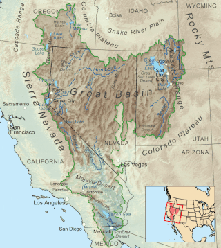
The Great Basin is the largest area of contiguous endorheic watersheds, those with no outlets to the ocean, in North America. It spans nearly all of Nevada, much of Utah, and portions of California, Idaho, Oregon, Wyoming, and Baja California. It is noted for both its arid climate and the basin and range topography that varies from the North American low point at Badwater Basin in Death Valley to the highest point of the contiguous United States, less than 100 miles (160 km) away at the summit of Mount Whitney. The region spans several physiographic divisions, biomes, ecoregions, and deserts.

<span class="mw-page-title-main">Black Rock Desert</span> Northwest Nevada dry lake

The Black Rock Desert is a semi-arid region of lava beds and playa, or alkali flats, situated in the Black Rock Desert–High Rock Canyon Emigrant Trails National Conservation Area, a silt playa 100 miles (160 km) north of Reno, Nevada that encompasses more than 300,000 acres (120,000 ha) of land and contains more than 120 miles (200 km) of historic trails. It is in the northern Nevada section of the Great Basin with a lakebed that is a dry remnant of Pleistocene Lake Lahontan.

<span class="mw-page-title-main">Petroglyph</span> Images carved on a rock surface as a form of rock art

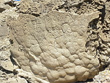
A petroglyph is an image created by removing part of a rock surface by incising, picking, carving, or abrading, as a form of rock art. Outside North America, scholars often use terms such as "carving", "engraving", or other descriptions of the technique to refer to such images. Petroglyphs, estimated to be 20,000 years old are classified as protected monuments and have been added to the tentative list of UNESCO's World Heritage Sites. Petroglyphs are found worldwide, and are often associated with prehistoric peoples. The word comes from the Greek prefix petro-, from πέτρα petra meaning "stone", and γλύφω glýphō meaning "carve", and was originally coined in French as pétroglyphe.

<span class="mw-page-title-main">Great Basin Desert</span> Desert in the western United States

The Great Basin Desert is part of the Great Basin between the Sierra Nevada and the Wasatch Range. The desert is a geographical region that largely overlaps the Great Basin shrub steppe defined by the World Wildlife Fund, and the Central Basin and Range ecoregion defined by the U.S. Environmental Protection Agency and United States Geological Survey. It is a temperate desert with hot, dry summers and snowy winters. The desert spans large portions of Nevada and Utah, and extends into eastern California. The desert is one of the four biologically defined deserts in North America, in addition to the Mojave, Sonoran, and Chihuahuan Deserts.

<span class="mw-page-title-main">Pyramid Lake (Nevada)</span> Lake in Nevada, United States

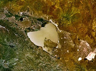
Pyramid Lake is the geographic sink of the basin of the Truckee River, 40 mi (64 km) northeast of Reno, Nevada, United States.
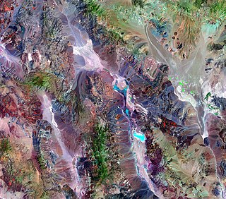
<span class="mw-page-title-main">Lake Lahontan</span> Former lake in Nevada, United States

Lake Lahontan was a large endorheic Pleistocene lake of modern northwestern Nevada that extended into northeastern California and southern Oregon. The area of the former lake is a large portion of the Great Basin that borders the Sacramento River watershed to the west.

<span class="mw-page-title-main">Derby Dam</span> United States historic place

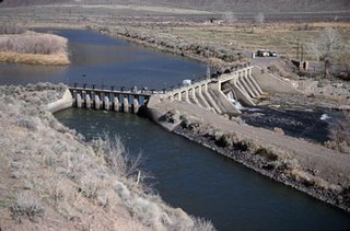
Derby Dam is a diversion dam built from 1903 to 1905 on the Truckee River, located about 20 miles (32 km) east of Reno in Storey and Washoe counties in Nevada, United States. It diverts water into the Truckee Canal that would otherwise enter Pyramid Lake. The canal feeds Lake Lahontan reservoir in the Carson River watershed, where it is used for irrigation.

<span class="mw-page-title-main">Truckee River</span> River in Nevada and California, United States

The Truckee River is a river in the U.S. states of California and Nevada. The river flows northeasterly and is 121 miles (195 km) long. The Truckee is the sole outlet of Lake Tahoe and drains part of the high Sierra Nevada, emptying into Pyramid Lake in the Great Basin. Its waters are an important source of irrigation along its valley and adjacent valleys.

<span class="mw-page-title-main">Indigenous peoples of the Great Basin</span> Cultural classification of Native Americans

The Indigenous peoples of the Great Basin are Native Americans of the northern Great Basin, Snake River Plain, and upper Colorado River basin. The "Great Basin" is a cultural classification of indigenous peoples of the Americas and a cultural region located between the Rocky Mountains and the Sierra Nevada, in what is now Nevada, and parts of Oregon, California, Idaho, Wyoming, and Utah. The Great Basin region at the time of European contact was ~400,000 sq mi (1,000,000 km2). There is very little precipitation in the Great Basin area which affects the lifestyles and cultures of the inhabitants.

<span class="mw-page-title-main">Walker River</span> River in Nevada, United States

The Walker River is a river in west-central Nevada in the United States, approximately 62 miles (100 km) long. Fed principally by snowmelt from the Sierra Nevada of California, it drains an arid portion of the Great Basin southeast of Reno and flows into the endorheic basin of Walker Lake. The river is an important source of water for irrigation in its course through Nevada; water diversions have reduced its flow such that the level of Walker Lake has fallen 160 feet (49 m) between 1882 and 2010. The river was named for explorer Joseph Reddeford Walker, a mountain man and experienced scout who is known for establishing a segment of the California Trail.

<span class="mw-page-title-main">Walker Lake (Nevada)</span> Lake in Nevada, United States

Walker Lake is a natural lake in the Great Basin in western Nevada in the United States. It is 11 mi (17 km) long and 5 mi (8 km) wide, in northwestern Mineral County along the east side of the Wassuk Range, about 75 mi (120 km) southeast of Reno. The lake is fed from the north by the Walker River and has no natural outlet except absorption and evaporation. The community of Walker Lake is found along the southwest shore.

<span class="mw-page-title-main">Geology of the Death Valley area</span> Geology of the area in California and Nevada

The exposed geology of the Death Valley area presents a diverse and complex set of at least 23 formations of sedimentary units, two major gaps in the geologic record called unconformities, and at least one distinct set of related formations geologists call a group. The oldest rocks in the area that now includes Death Valley National Park are extensively metamorphosed by intense heat and pressure and are at least 1700 million years old. These rocks were intruded by a mass of granite 1400 Ma and later uplifted and exposed to nearly 500 million years of erosion.

<span class="mw-page-title-main">Lahontan cutthroat trout</span> Subspecies of fish

Lahontan cutthroat trout is the largest subspecies of cutthroat trout, and the state fish of Nevada. It is one of three subspecies of cutthroat trout that are listed as federally threatened.

<span class="mw-page-title-main">Honey Lake</span> Lake in California, United States

Honey Lake is an endorheic sink in the Honey Lake Valley in northeastern California, near the Nevada border. Summer evaporation reduces the lake to a lower level of 12 square kilometers and creates an alkali flat. Honey Lake dries almost completely in most years.

<span class="mw-page-title-main">History of Nevada</span>

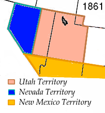
The History of Nevada as a state began when it became the 36th state on October 31, 1864, after telegraphing the Constitution of Nevada to the Congress days before the November 8 presidential election. Statehood was rushed to help ensure three electoral votes for Abraham Lincoln's reelection and add to the Republican congressional majorities.

<span class="mw-page-title-main">Lovelock Cave</span> Cave in United States of America

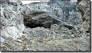
Lovelock Cave (NV-Ch-18) is a North American archaeological site previously known as Sunset Guano Cave, Horseshoe Cave, and Loud Site 18. The cave is about 150 feet (46 m) long and 35 feet (11 m) wide. Lovelock Cave is one of the most important classic sites of the Great Basin region because the conditions of the cave are conducive to the preservation of organic and inorganic material. The cave was placed on the National Register of Historic Places on May 24, 1984. It was the first major cave in the Great Basin to be excavated, and the Lovelock Cave people are part of the University of California Archaeological Community's Lovelock Cave Station.

<span class="mw-page-title-main">Grimes Point</span> United States historic place

Grimes Point, in Churchill County, Nevada near Fallon, is a 720-acre (290 ha) archeological site that was listed on the U.S. National Register of Historic Places in 1972. It was listed for its potential to yield future information.

<span class="mw-page-title-main">Picture Rock Pass Petroglyphs Site</span> United States historic place

The Picture Rock Pass Petroglyphs Site is in northern Lake County, Oregon, United States. The site is located near the summit of Picture Rock Pass on land administered by the Bureau of Land Management. The designs were scraped into a basalt boulder by ancient Native Americans, probably between 7,500 and 12,000 years ago. No one knows the meaning of the petroglyph designs. Because of its unique archaeological and cultural significance, the Picture Rock Pass Petroglyph Site was listed on the National Register of Historic Places in 1975.

Neopluvial is a term referring to a phase of wetter and colder climate that occurred during the late Holocene in the Western United States. During the Neopluvial, water levels in a number of now-dry lakes and closed lakes such as the Great Salt Lake rose and vegetation changed in response to increased precipitation. The event was not exactly synchronous everywhere, with neopluvial lake-level rises occurring between 6,000 and 2,000 years ago. It is correlative to the Neoglacial period.

<span class="mw-page-title-main">Geology of Nevada</span>

The geology of Nevada began to form in the Proterozoic at the western margin of North America. Terranes accreted to the continent as a marine environment dominated the area through the Paleozoic and Mesozoic periods. Intense volcanism, the horst and graben landscape of the Basin and Range Province originating from the Farallon Plate, and both glaciers and valley lakes have played important roles in the region throughout the past 66 million years.

References

  1. U.S. Geological Survey Geographic Names Information System: Winnemucca Lake
  2. 1 2 3 4 5 6 7 8 Larry Benson; E.M. Hattorib; J. Southonc; B. Aleckd (December 2013). "Dating North America's oldest petroglyphs, Winnemucca Lake subbasin, Nevada". Journal of Archaeological Science. 40 (12): 4466–4476. Bibcode:2013JArSc..40.4466B. doi:10.1016/j.jas.2013.06.022.
  3. Kumiva Peak, Nevada—California, 30x60 Topographic Quadrangle, USGS, 1984.
  4. Reno, Nevada—California, 30x60 Topographic Quadrangle, USGS, 1980.
  5. 1 2 Jeremy Pratt (September 1997). Truckee-Carson River Basin Study (PDF) (Report). The Western Water Policy Review Advisory Commission. p. 7. Retrieved 2013-08-21.
  6. Cassinelli, Dennis (2018-01-11). "Stories of Old Nevada: Fishing Winnemucca Lake". Elko Free Press. Retrieved 2018-10-14.
  7. 1 2 Hattori, Eugene M.; Tuohy, Donald R. (May 1993). "Prehistoric Human Occupation and Changing Lake Levels at Pyramid and Winnemucca Lakes Nevada". In Benson, Larry V. (ed.). Proceedings of the Workshop "Ongoing Paleoclimactic Studies in the Northern Great Basin". US Geological Survey Circular. No. 1119. p. 32. Retrieved 2018-10-14. When J. C. Fremont entered the region in 1844, Winnemucca Lake may have been dry
  8. Report of the exploring expedition to the Rocky Mountains in the year 1842, and to Oregon and North California in the years 1843–44. 1845. p.  216 . Retrieved 2018-11-02.
  9. Frémont, John C. (1845). Map Of An Exploring Expedition To The Rocky Mountains (Map). Retrieved 2018-11-02.
  10. Russell, Israel Cook (1885). Geological History of Lake Lahontan: A Quaternary Lake of Northwestern Nevada. U.S. Government Printing Office. pp.  63–66. winnemucca.
  11. Hopkins, Sarah Winnemucca (1883). Life Among the Piutes: Their Wrongs and Claims. G.P Putnam's Sons. p.  77.
  12. David James Duncan (1993-10-17). "Troutfishing in the Lake of the Stone Mother: A Sportsman Reflects on the Abuse of a Nevada Lake, Language and the Land". The Los Angeles Times. Retrieved 2013-08-21.
  13. Pyramid Lake Fishway Replacement Feasibility Study (PDF) (Technical report). U.S. Army Engineer District, Sacramento. November 2000. p. 3. PAP-863. Retrieved 2013-08-21.
  14. 1 FR 1335
  15. 5 FR 2680
  16. U.S. Geological Survey Geographic Names Information System: Winnemucca National Wildlife Refuge (historical)
  17. 27 FR 5504
  18. 1 2 3 4 Ker Than (August 15, 2013). "Oldest North American Rock Art May Be 14,800 Years Old". National Geographic. Archived from the original on August 17, 2013. Retrieved August 16, 2013.
  19. 1 2 3 Zoe Mintz (August 14, 2013). "Oldest Rock Carvings In North America Confirmed, Scientists Have 'No Idea' What Petroglyphs Mean". International Business Times. Retrieved August 15, 2013.