
The Metropolitan Borough of Wigan is a metropolitan borough of Greater Manchester, in North West England. It is named after the main settlement of Wigan. It covers the towns of Atherton, Ashton-in-Makerfield, Golborne, Hindley, Ince-in-Makerfield, Leigh and Tyldesley. The borough also covers the villages and suburbs of Abram, Aspull, Astley, Bryn, Hindley Green, Lowton, Mosley Common, Orrell, Pemberton, Shevington, Standish, Winstanley and Worsley Mesnes. The borough is also the second-most populous district in Greater Manchester.

Winstanley College is a sixth-form college in the Billinge Higher End area of the Metropolitan Borough of Wigan, Greater Manchester.

Orrell is a ward of the Metropolitan Borough of Wigan, Greater Manchester, England. The population of the ward had fallen at the 2011 Census to 11,513. The centre of the area lies 3 miles (4.8 km) to the west of Wigan town centre and serves as a predominantly residential suburb of Wigan. The area is contiguous with the district of Pemberton.

Pemberton railway station serves the Pemberton area of Wigan in Greater Manchester, England. It is on the Kirkby branch line from Wigan Wallgate.

Billinge is a village within the Metropolitan Borough of St Helens, Merseyside, England. It forms the larger part of the civil parish of Billinge Chapel End.
Ince was a parliamentary constituency in England which elected one Member of Parliament (MP) to the House of Commons of the Parliament of the United Kingdom. It comprised the town of Ince-in-Makerfield and other towns south of Wigan.
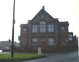
Pemberton is a town and an electoral ward of the Metropolitan Borough of Wigan, in Greater Manchester, England. It lies on the southwestern bank of the River Douglas, which separates it from the town of Wigan, and east of the M6 motorway. The area today serves as a predominantly residential suburb along with the adjoining area of Orrell and as a ward has a population of 13,638, increasing to 13,982 at the 2011 Census.
Billinge was, from 1872 to 1974, a local government district in the administrative county of Lancashire, England.

Wigan is a large town in Greater Manchester, England, on the River Douglas. The town is midway between the two cities of Manchester, 16 miles (25.7 km) to the south-east, and Liverpool, 17 miles (27 km) to the south-west. Bolton lies 10 miles (16 km) to the north-east and Warrington 12 miles (19 km) to the south. It is the largest settlement in the Metropolitan Borough of Wigan and is its administrative centre. The town has a population of 107,732 and the wider borough of 330,713. Wigan was formerly within the historic county of Lancashire.
Higher End or Billinge Higher End is an area of the Metropolitan Borough of Wigan, Greater Manchester, England.

Billinge Hospital was a National Health Service facility in the Billinge Higher End district of the Metropolitan Borough of Wigan, Greater Manchester, England. It was managed by the 5 Boroughs Partnership NHS Trust.

Longshaw is a small residential and agricultural area within Billinge Higher End at the western boundary of the Metropolitan Borough of Wigan, in Greater Manchester, England. It is situated at the northern foot of Billinge Hill on the B5206 road. Historically, Longshaw was part of Lancashire.

Winstanley Hall is a late 16th-century house in Winstanley, in the Metropolitan Borough of Wigan, Greater Manchester. It is listed as a Scheduled Ancient Monument and a Grade II* listed building. Originally built for the Winstanley family, the building is one of only three Tudor buildings in the Borough.

The Wigan Metropolitan Borough Council is the local authority for the Metropolitan Borough of Wigan in the United Kingdom. It consists of 75 Councillors with one-third being elected every three years in four. The borough is separated into 25 wards. Councillors are democratically accountable to the ward they are elected to represent. Each ward is represented on the council by three council members.
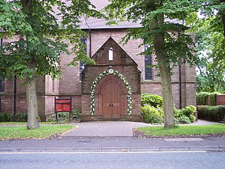
St Matthew's Church is in Billinge Road, Highfield, Pemberton, Wigan, Greater Manchester, England. It is an active Anglican parish church in the deanery of Wigan, the archdeaconry of Wigan & West Lancashire, and the diocese of Liverpool. The church is recorded in the National Heritage List for England as a designated Grade II* listed building.

Bispham Hall is a Grade II* listed Elizabethan country house in Billinge, now part of the Metropolitan Borough of Wigan, Greater Manchester.
Billinge and Winstanley is an area in the Metropolitan Borough of Wigan, Greater Manchester, England. The area, which consists of small settlements and surrounding countryside, includes eleven listed buildings that are recorded in the National Heritage List for England. Of these, three are listed at Grade II*, the middle of the three grades, and the others are at Grade II, the lowest grade. Most of the listed buildings are houses and associated structures, the others being monuments and a set of stocks.

