Elkridge is an unincorporated community and census-designated place (CDP) in Howard County, Maryland, United States. The population was 15,593 at the 2010 census. Founded early in the 18th century, Elkridge is adjacent to two other counties, Anne Arundel and Baltimore.

The Stevensville Historic District, also known as Historic Stevensville, is a national historic district in downtown Stevensville, Queen Anne's County, Maryland. It contains roughly 100 historic structures, and is listed on the National Register of Historic Places. It is located primarily along East Main Street, a portion of Love Point Road, and a former section of Cockey Lane.

University Town Center, formerly New Town Center, is located in Hyattsville, Prince George's County, Maryland, United States. It was a planned urban center designed by Edward Durell Stone and located on a 105-acre (0.42 km2) parcel at the intersection of Belcrest Road and East-West Highway and across from the then new Prince George's Plaza. The initial construction on this development took place in 1963-64; its buildings are listed on the National Register of Historic Places. A second phase commenced after the opening of the Prince George's Plaza station, Washington Metro rapid transit station in 1993.

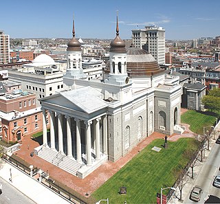
The Cathedral Hill Historic District is an area in Baltimore, Maryland. It lies in the northern part of Downtown just south of Mount Vernon. Roughly bounded by Saratoga Street, Park Avenue, Hamilton Street, and St. Paul Street, these 10 or so blocks contain some of the most significant buildings in Baltimore. The area takes its name from the Basilica of the Assumption which sits in the heart of the district. Despite the number of large religious structures in the area, the district's buildings are primarily commercial in character, with a broad collection of significant commercial structures ranging in date from 1790 to 1940.

Linthicum Heights Historic District is a national historic district at Linthicum Heights, Anne Arundel County, Maryland. It consists of a suburban community surrounding the intersection of Camp Meade Road and Maple Road. The community is situated on a series of low hills about three miles south of the Patapsco River and includes 17 tree-shaded streets created originally as a planned railroad suburb on the lines connecting Baltimore, Annapolis, and Washington, beginning in 1908. The district consists of 254 contributing resources, including two churches, a cemetery, and a former commercial/residential building. Most of the housing was built prior to 1939 and include examples of the Bungalow, American Foursquare, Colonial Revival, Dutch Revival, and Tudor Revival styles.

The Chapel Hill Historic District is a national historic district in Cumberland, Allegany County, Maryland. It is a mixed-use historic district of 810 contributing resources on 145 acres (0.59 km2) located on the southeast side of Cumberland. It contains a mix of residential, commercial, and institutional buildings, with St. Mary's Roman Catholic Church on the highest point. The vast majority of the buildings were built between 1900 and 1910, and includes an extraordinary collection of double houses built for the industrial working class of the city.

The Decatur Heights Historic District is a national historic district in Cumberland, Allegany County, Maryland. It is a mixed-use district of 77 acres (310,000 m2) located on the northeast side of Cumberland. It contains a total of 377 residential / commercial / industrial historic resources, including five properties previously listed on the National Register of Historic Places. Approximately 50 percent of the resources in the district predate 1890, approximately 40 percent date were constructed between 1890 and 1930, and the remaining approximately 10 percent post-date 1930. It is significant because: 1) its association with the history of African-American education in Cumberland; 2) its association with the exploration and settlement of the region, with its location along the National Road; and 3) the dense concentration of primarily residential buildings built between about 1820 and the 1940s.

The Mount Airy Historic District is a national historic district in Mount Airy, located in Carroll and Frederick County, Maryland. The district comprises a cohesive group of commercial, residential, and ecclesiastical buildings dating from the late 19th through early 20th centuries. The brick Baltimore and Ohio Railroad station, designed by E. Francis Baldwin and constructed in 1882, represents the town's origin as an early transportation center for the region, which dates back as early as 1838. A group of early-20th century commercial structures represent the rebuilding of Mount Airy's downtown after a series of fires between 1903 and 1926. The residential areas are characterized by houses illustrating vernacular forms and popular stylistic influences of the late 19th and early 20th century. Three churches are located within the district.

Johnsville is an unincorporated community in Frederick County, Maryland, United States. It is located approximately halfway between Libertytown and Union Bridge along Maryland Route 75. The Kitterman-Buckey Farm was listed on the National Register of Historic Places in 2005.

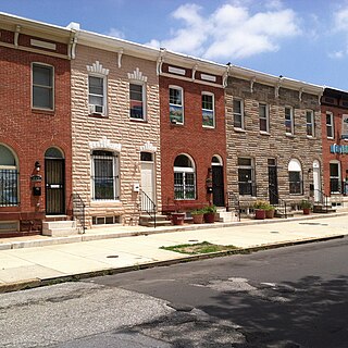
South Central Avenue Historic District is a national historic district in Baltimore, Maryland, United States. It contains brick two- and three-story industrial and residential buildings reflecting over 150 years of utilitarian adaptation of buildings and space. The district includes early 19th century rowhouses, late 19th century and early 20th century manufacturing and warehouse buildings, gas stations, stables, car barns, commercial/residential buildings, and corner stores. Several larger buildings are the Bagby Furniture Company Building, the Strauss Malt House, and the Alameda School. Many rowhouses have been covered with formstone.

Dundalk Historic District is a national historic district in Baltimore, and Baltimore County, Maryland, United States. The district is a cohesive unit made up of residential, commercial, and institutional buildings with structures that generally date from 1910 to 1940. Major architectural styles represented include Period Revival and Art Deco/Streamline Moderne. The District includes 962 resources contribute to its significance. It includes the only two housing developments built by the United States Shipping Board Merchant Fleet Corporation (EFC) in Maryland during World War I and reflects experimentation with Garden City planning ideals. Many of the buildings within the District represent the work of noted Baltimore architect Edward L. Palmer, Jr.

Old Goucher College Buildings is a national historic district in Baltimore, Maryland, United States. It is an approximate 18-block area in the middle of Baltimore which developed in the late 19th and 20th centuries.

Franklintown Historic District is a national historic district in Baltimore, Maryland, United States. It is the result of a plan developed in 1832 by William H. Freeman (1790–1863), a local politician and entrepreneur. His plan evolved gradually over the course of several decades and owes its success to his untiring promotion of the village. The central feature is an oval plan with radiating lots around a central wooded park. The district includes an old stone grist mill known as Franklin Mill, the innovative radiating oval plan, and the associated hotel and commercial area. The key residential buildings are excellent examples of the "I"-house form and display steeply pitched cross gables found in vernacular rural buildings throughout much of Maryland.

Arcadia–Beverly Hills Historic District is a national historic district in Baltimore, Maryland, United States. It is a cohesive residential suburb comprising approximately 30 irregularly shaped blocks containing some 900 buildings. They are primarily freestanding masonry and frame houses set back from the streets with small front yards. Early-20th century suburban architectural styles represented in the district include foursquare, bungalows, early suburban villas, Colonial Revival, Tudor Revival, and Pueblo Revival. Also included are two churches, a 45-acre (180,000 m2) cemetery, and a variety of commercial buildings along Harford and Belair Roads. Herring Run Park provides a wooded park setting for the community. The earliest structure in the community was constructed in 1887, and the district had substantially achieved its existing form and appearance by 1950.

Baltimore East/South Clifton Park Historic District is a national historic district in Baltimore, Maryland, United States. It is primarily an urban residential area organized in a gridiron pattern. It comprises approximately 110 whole and partial blocks that formed the historic northeast corner of the City of Baltimore prior to 1888. While rowhouses dominate the urban area, the historic district also contains other property types which contribute to its character including brewing, meat packing, cigar manufacturing, printing, and a tobacco warehouse. The Baltimore Cemetery completes the historic district.

Granite Historic District is a national historic district in Granite, Baltimore County, Maryland, United States. It comprises the focus of a rural quarrying community located in the Patapsco Valley of western Baltimore County, Maryland. It includes two churches, a school, a social hall, former commercial buildings, and houses and outbuildings, representing the period from the initial settlement of the area about 1750 through the early 20th century, when the village achieved its present form. The district also includes the former Waltersville quarry, one of two major granite operations in the region during the period. Granite from the Waltersville and Fox Rock quarries was utilized in construction of the Baltimore & Ohio Railroad in the 1830s, and later in such projects as the Library of Congress, old Treasury Building, and parts of the inner walls of the Washington Monument in Washington, D.C., and numerous other projects in Baltimore city and county.

Green Spring Valley Historic District is a national historic district near Stevenson in Baltimore County, Maryland, United States. It is a suburban area of Baltimore that acquires significance from the collection of 18th, 19th, and early 20th century buildings. The park-like setting retains a late 19th-early 20th century atmosphere. At the turn of the 20th century, the Maryland Hunt Cup and the Grand National Maryland steeplechase races were run over various parts of the valley. The Maryland Hunt Cup, which began as a competition between the Green Spring Valley Hunt and the Elkridge Hunt, traditionally started at Brooklandwood, the previous home of Charles Carrol of Carrollton with the finish across Valley Road at Oakdene, at that time the home of Thomas Deford, which remains a private residence

East Monument Historic District or Little Bohemia, is a national historic district in Baltimore, Maryland. It is a large residential area with a commercial strip along East Monument Street. It comprises approximately 88 whole and partial blocks. The residential area is composed primarily of rowhomes that were developed, beginning in the 1870s, as housing for Baltimore's growing Bohemian (Czech) immigrant community. During the late 19th and early 20th centuries the neighborhood was the heart of the Bohemian community in Baltimore. The Bohemian National Parish of the Roman Catholic Church, St. Wenceslaus, is located in the neighborhood. The historic district includes all of McElderry Park and Milton-Montford, most of Middle East and Madison-Eastend, and parts of Ellwood Park.
The Upper Marlboro Residential Historic District is a national historic district encompassing a historic residential area of Upper Marlboro, Maryland. The area reflects the town's growth from the 18th to the 20th century, including its importance as the county seat of Prince George's County. The district also contained a significant post-American Civil War African-American population, which was making the transition from slavery to freedom. Located in the district are three previously listed properties: Kingston, Content, and the John H. Traband House. Prominent features of the district include the Trinity Episcopal Church at 14519 Church Street, an 1846 Gothic Revival church designed by Robert Carey Long, Jr., and 5415 Old Crain Highway, a 1+1⁄2-story wood-frame house dated to c. 1730, which is believed to be the oldest building in the town.

The Bare Hills Historic District encompasses a residential area north of Baltimore, Maryland, in Baltimore County, which had industrial beginnings before being transformed into a suburb of the city. The district includes Lake Roland Park as well as a cluster of largely vernacular dwellings between the park and Falls Turnpike that was built mainly in the 19th century.


