
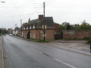
Bridge Hewick is a village and civil parish in the Harrogate district of North Yorkshire, England. The village is situated on the River Ure, and approximately 2 miles (3 km) east of the market town of Ripon. The population was recorded at less than 100 at the 2011 Census. Details are included on the statistics of the civil parish of Copt Hewick. North Yorkshire County Council estimate that the population at the 2011 census was 50, which had risen to 60 by 2015.

Ellerbeck is a small village and civil parish in North Yorkshire, England. The population of the parish was estimated at 50 in 2011 and 2011. As the population taken at the 2011 Census remained less than 100, the details are maintained in the civil parish of Winton, Stank and Hallikeld.

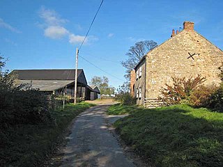
Kirby Sigston is a village and civil parish in the Hambleton district of North Yorkshire, England, approximately 4 miles (6.4 km) east of Northallerton. The village is situated on the Cod Beck river, and the wider parish contains the hamlet of Jeater Houses due east of the village on the trunk A19 road.

Hutton Conyers is a village and civil parish in the Harrogate district of North Yorkshire, England. It is situated near the River Ure and 1-mile (1.6 km) north-east of Ripon. The parish extends from the River Ure to the A1(M) motorway, and includes the village of Nunwick.

Langthorpe is a village and civil parish in the Harrogate district of North Yorkshire, England. The population of the civil parish taken at the 2011 Census was 812. It is situated to the immediate north of Boroughbridge on the A168 road.

Milby is a hamlet and civil parish in the Harrogate district of North Yorkshire, England. It is situated to the immediate north of Boroughbridge.

West Harlsey is a hamlet and civil parish in the Hambleton district of North Yorkshire, England. The population as taken at the 2011 Census was less than 100. Details are included in the civil parish of Winton, Stank and Hallikeld. It is situated near the A19 road, 3 miles north east of Northallerton.
Stoborough is a village in the English county of Dorset. It is situated one mile to the south of the town of Wareham, and separated from it by the River Frome. Stoborough and nearby Stoborough Green form part of the civil parish of Arne.
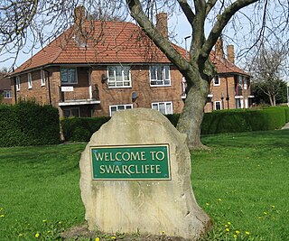
Swarcliffe, originally the Swarcliffe Estate, is a district of Leeds, West Yorkshire, England. It is 4.9 miles (8 km) east of Leeds city centre, and within the LS14 and LS15 Leeds postcode area. The district falls within the Cross Gates and Whinmoor ward of the Leeds Metropolitan Council.
Kaber is a village and civil parish in the Eden District of Cumbria, England.
Winton is a suburb of Bournemouth in Dorset, England. It lies approximately 1 mile (1.6 km) north of Bournemouth town centre, along Wimborne Road. Winton is to the east of Wallisdown, Victoria Park and Talbot Woods and south of Moordown.

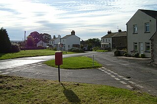
Winton is a village and civil parish in the Eden District of Cumbria, England. It is 2.9 miles (4.7 km) south of Brough, and 1.6 miles (2.6 km) north of Kirkby Stephen, and had a population of 213 at the 2001 Census. At the 2011 census Winton was grouped with Kaber giving a total population of 327. The word Winton is Old English or Anglo-Saxon in origin, Wyntuna meaning a pasture. Farmstead was first identified in 1094, shortly after the Norman Conquest, during a period known as the 'Harrying of the North'. On 12 April 1659, the village of Winton was at the centre of the Westmorland witch trials, during which several women were hanged at Appleby General Sessions, found guilty of bewitching Margaret Bousefield.

Cundall is a village in the Harrogate district of North Yorkshire, England. It is one of the Thankful Villages that suffered no fatalities during World War I.

Sowerby-under-Cotcliffe is a civil parish in the Hambleton District of North Yorkshire, England. The population at the 2011 Census was less than 100. Details are included in the civil parish of Winton, Stank and Hallikeld. It is 3 miles (4.8 km) east of Northallerton, 0.5 miles (0.8 km) south of Kirby Sigston, and 1.2 miles (2 km) west of the A19 road. The Cod Beck river flows to the east of the parish forming a border with KIrby Sigston and Landmoth-cum-Catto civil parishes.
Winton is a civil parish in the Eden District, Cumbria, England. It contains twelve listed buildings that are recorded in the National Heritage List for England. Of these, one is listed at Grade II*, the middle of the three grades, and the others are at Grade II, the lowest grade. The parish includes the village of Winton, and is otherwise rural. The listed buildings consist of houses and associated structures, farmhouses and farm buildings, and a pinfold, a boundary stone, and a former school.
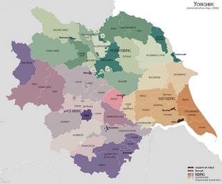
Hallikeld was a Wapentake (Hundred), which is an administrative division, in the historic county of the North Riding of Yorkshire. It was one of the smaller wapentakes by area and consisted of seven parishes.
Binsoe is a hamlet in the civil parish of West Tanfield, North Yorkshire, England. The hamlet is just to the north of the A6108 road, being 1.25 miles (2 km) north west of West Tanfield, and 2 miles (3.2 km) south east of Masham. During the First World War, a field to the east of the hamlet was used as a landing ground for the Royal Flying Corps.
