The Liard River First Nation, also known as the Liard First Nation is a First Nation in the southeastern Yukon in Canada. Its main centres are Upper Liard and Watson Lake along the Alaska Highway. The language originally spoken by the people of this First Nation was Kaska and the First Nation is a member of the Kaska Tribal Council which is pursuing land claims in the Yukon and northern British Columbia. Their Indian and Northern Affairs Canada band number is 502.

The Wetʼsuwetʼen are a First Nation who live on the Bulkley River and around Burns Lake, Broman Lake, and François Lake in the northwestern Central Interior of British Columbia.
The Skatin First Nations, aka the Skatin Nations, are a band government of the In-SHUCK-ch Nation, a small group of the larger St'at'imc people who are also referred to as Lower Stl'atl'imx. The Town of Skatin - the St'at'imcets version of the Chinook Jargon Skookumchuck- is located 4 km south of T'sek Hot Spring- alt. spelling T'sek Hot Spring - commonly & formerly named both St. Agnes' Well & Skookumchuck Hot Springs The community is 28 km south of the outlet of Lillooet Lake on the east side of the Lillooet River. It is approximately 75 km south of the town of Pemberton and the large reserve of the Lil'wat branch of the St'at'imc at Mount Currie. Other bands nearby are Samahquam at Baptiste Smith IR on the west side of the Lillooet River at 30 km. and Xa'xtsa First Nations; the latter is located at Port Douglas, near the mouth of the Lillooet River where it enters the head of Harrison Lake. The N'Quatqua First Nation on Anderson Lake, between Mount Currie and Lillooet, was at one time involved in joint treaty negotiations with the In-SHUCK-ch but its members have voted to withdraw, though a tribal council including the In-SHUCK-ch bands and N'Quatqua remains, the Lower Stl'atl'imx Tribal Council.

The Wetʼsuwetʼen First Nation is a Wetʼsuwetʼen First Nations band located outside of the village of Burns Lake, British Columbia, Canada. It was formerly known as the Broman Lake Indian Band and is still usually referred to as Broman Lake although this is no longer its official name. Its members speak the Wetʼsuwetʼen dialect of Babine-Witsuwitʼen, a Northern Athabaskan language. The main community is on Palling Indian Reserve No. 1.

Witset is a Wet'suwet'en village in Central British Columbia, Canada on the west side of the Bulkley River on Coryatsaqua (Moricetown) Indian Reserve No. 2, and on Moricetown Indian Reserve No.1. The current village was built during the early 1900s. Evidence of inhabitants date back to around 5,500 years ago.
The Spallumcheen Indian Band, also called the Splats'in First Nations is a member of the Secwepemc (Shuswap) Nation, located in the Central Interior region of the Canadian province of British Columbia. Its main Indian reserve is located at Enderby, British Columbia. It was created when the government of the then-Colony of British Columbia established an Indian reserve system in the 1860s. It is a member government of the Shuswap Nation Tribal Council.
The Williams Lake First Nation is a First Nations government of the Secwépemc Nation, located in the Cariboo region of the Central Interior region of the Canadian province of British Columbia, at the city of Williams Lake. It was created when the government of the then-Colony of British Columbia established an Indian reserve system in the 1860s. It is a member government of the Northern Shuswap Tribal Council. Its main Indian Reserve is Williams Lake Indian Reserve No. 1, a.k.a. "Sugarcane" or "The Cane" or "SCB".
The Pavilion Indian Band or Ts'kw'aylaxw First Nation or Tsk'waylacw First Nation or Tsk'weylecw First Nation, and also known in the plural e.g. Ts'kw'alaxw First Nations, is a First Nations government, located in the Fraser Canyon region of the Central Interior of the Canadian province of British Columbia. It was created when the government of the then-Colony of British Columbia established an Indian reserve system in the 1860s.
The Red Bluff First Nation is a Dakelh First Nations government located in the northern Fraser Canyon region of the Canadian province of British Columbia. It is a member of the Carrier-Chilcotin Tribal Council, which includes both Tsilhqot'in and Carrier (Dakelh) communities.
The Stone First Nation or Yunesitʼin First Nation is a band government of the Yunesit'in subgroup of the Tsilhqot'in people, whose territory is the Chilcotin District in the western Central Interior region of the Canadian province of British Columbia. It is a member of the Tsilhqot'in Tribal Council. The people of the Stone First Nation are known as the Yunesit'in in the Chilcotin language.

The Lil'wat First Nation, a.k.a. the Lil'wat Nation or the Mount Currie Indian Band, is a First Nation band government located in the southern Coast Mountains region of the Interior of the Canadian province of British Columbia. It is a member of the Lillooet Tribal Council, which is the largest grouping of band governments of the St'at'imc or Stl'atl'imx people. Other St'at'imc governments include the smaller In-SHUCK-ch Nation on the lower Lillooet River to the southwest, and the independent N'quatqua First Nation at the near end of Anderson Lake from Mount Currie, which is the main reserve of the Lil'wat First Nation, and also one of the largest Indian reserves by population in Canada.
The Dease River First Nation, also known as the Dease River Nation, is a band government of the Kaska Dena people in the Cassiar Country of the Northern Interior of British Columbia. Their offices are located in Good Hope Lake, British Columbia, which is on the Stewart-Cassiar Highway to the east of the abandoned mining town of Cassiar. The registered population of the band is 162.
The Kitasoo/Xaixais First Nation, also known as the Kitasoo/Xaixais Nation, is the band government of the First Nations people of Klemtu, British Columbia, Canada. The band comprises two ethnic groups who share an ancient alliance, the Kitasoo, a Tsimshian group, and the Xai'xais, a North-Wakashan speaking group. The government is a member of the Oweekeno-Kitasoo-Nuxalk Tribal Council and a member of the Tsimshian First Nations treaty council.
Yale First Nation is a First Nations government located at Yale, British Columbia. Yale has 16 distinct reserves stretching from near Sawmill Creek to American Creek, with the most southern reserve situated at Ruby Creek in the District of Kent.
The Gwawaenuk Tribe, or Gwawaʼenux̱w is a First Nations band government of the Kwakwaka'wakw people located in the Queen Charlotte Strait region of the Central Coast region of British Columbia, Canada. The Gwawaenuk Tribe has no year-round road access to a service centre and being about 160 km to 240 km from the nearest service centre.
The Aitchelitz First Nation, also known as the Aitchelitz Band, is a First Nations band government of the Sto:lo people, located at Sardis, British Columbia, Canada (Chilliwack). It is a member of the Sto:lo Nation tribal council.
Kitselas First Nation is the band government of the Kitselas subgroup of the Tsimshian. The band government is based at Gitaus in the Skeena Valley in the Skeena River valley to the northeast of the city of Terrace, British Columbia, Canada. Though there is no Tsimshian tribal council, they are a participant in the Tsimshian First Nations treaty council.
Kitsumkalum First Nation is a band government of the Tsimshian people based at Kitsumkalum, British Columbia in the Skeena River valley in the North Coast region near Terrace, British Columbia, Canada. They are a member government of the Tsimshian First Nations treaty council.
The Leq'á:mel First Nation, formerly known as Lakahahmen First Nation, is a First Nations band government whose community and offices are located in the area near Deroche, British Columbia in the Fraser Valley region in Canada, about 12 kilometres east of the District of Mission. They are a member government of the Sto:lo Nation Chiefs Council, which is one of two tribal councils of the Sto:lo.
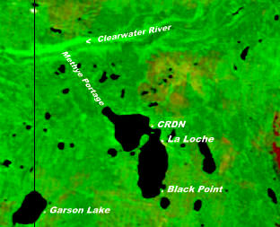
The Clearwater River Dene Nation is a Dene First Nations band government in the boreal forest area of northern Saskatchewan, Canada. It maintains offices in the village of Clearwater River situated on the eastern shore of Lac La Loche. The Clearwater River Dene Nation reserve of Clearwater River shares its southern border with the village of La Loche.
