Witt, Tennessee

Last updated
Witt, Tennessee
Witt
Sinking Creek - Morristown, TN (Witt).jpg
Sinking Creek in Witt
USA Tennessee location map.svg
Red pog.svg
Witt
Usa edcp location map.svg
Red pog.svg
Witt
Coordinates: 36°09′0″N83°16′58″W / 36.15000°N 83.28278°W / 36.15000; -83.28278 Coordinates: 36°09′0″N83°16′58″W / 36.15000°N 83.28278°W / 36.15000; -83.28278
Country United States
State Tennessee
County Hamblen
City Morristown
Time zone UTC-5 (Eastern (EST))
  Summer (DST) UTC-4 (EDT)
ZIP code
37813
Area code(s) 423
GNIS feature ID 1304642

Witt is an unincorporated community in Hamblen County, Tennessee, United States. [1]

Contents

History

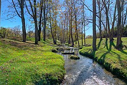
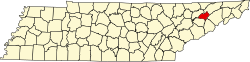
Witt was settled by its namesake Caleb Witt, an American Revolutionary War veteran, and at least two of his brothers in 1783 when the area was still known as the State of Franklin. [2] They established Witt's Foundry and a community slowly began to grow. Caleb Witt went on to become a locally well-known pastor until his death in 1827. Witt School was created around 1916 and was replaced by the newly constructed Witt Elementary in 1951. The elementary school is still in use and has had additions to the building in 1968, 1992, and 2001. Witt Elementary School is part of the Hamblen County Board of Education. [3]

Geography

Witt is located near Tennessee State Route 113, Tennessee State Route 32, Interstate 81, and a freight rail route. Other than some parts already annexed by Morristown, Witt is located around 6 miles (9.7 km) south of Morristown's central business district. [4]

Economy

Witt is now primarily used as the site of the East Tennessee Progress Center (ETPC) industrial park. [5] All of the factories and industrial complexes formally in Witt have now been annexed into the larger city of Morristown. Notable companies that have locations in the Witt area of Morristown are International Paper, Kawasaki Tennessee (a subsidiary of Kawasaki Heavy Industries), and Koch Foods. [5]

In 2018, Belgian bus manufacturer Van Hool announced the construction of a 500,000 square feet (46,000 m2) facility at the ETPC, [5] one of the largest industrial development projects in the history of Morristown. [6]


Related Research Articles

Hamblen County, Tennessee U.S. county in Tennessee

Hamblen County is a county located in the U.S. state of Tennessee. As of the 2010 census, the population was 62,544. Its county seat and only incorporated city is Morristown.

Grainger County, Tennessee U.S. county in Tennessee

Grainger County is a county located in the U.S. state of Tennessee. As of the 2010 census, the population was 22,657. Its county seat is Rutledge.

Blaine, Tennessee Knoxville suburb and city in Grainger County, Tennessee

Blaine is a city in Grainger County, Tennessee, United States, and a suburb of the neighboring city of Knoxville. It is part of both the Knoxville Metropolitan Statistical Area and the Morristown Metropolitan Statistical Area. The population was 1,856 at the 2010 census, an increase of 271 individuals since the 2000 census.

Jefferson City, Tennessee City in Jefferson County, Tennessee, United States

Jefferson City is a city in Jefferson County, Tennessee, United States. It is part of the Morristown Metropolitan Statistical Area. As of the 2010 census the population was 8,047.

Morristown, Tennessee Largest city and county seat of Hamblen County, Tennessee, United States

Morristown is a city in and the county seat of Hamblen County, Tennessee, United States. Morristown also extends into Jefferson County on the west and southern ends. The population was 29,137 at the 2010 United States Census, and was estimated to be 30,193 in 2019. In 2019, the city was reported to have a daytime population of 118,600.

White Pine, Tennessee Town in Jefferson and Hamblen counties in Tennessee, United States

White Pine is a town in Jefferson and Hamblen counties in Tennessee, United States. It is part of the Morristown Metropolitan Statistical Area. The population was 2,196 at the 2010 census.

Bean Station, Tennessee Lakeside town in Grainger County, Tennessee

Bean Station is a town in Grainger and Hawkins counties in the state of Tennessee, United States. As of the 2010 census, the population was 2,826. Settled in 1776, it is considered to be one of the earliest settled communities in Tennessee.

Morristown College United States historic place

Morristown College was an African American higher education institution located in Morristown, the seat of Hamblen County, Tennessee. It was founded in 1881 by the national Freedman's Aid Society of the Methodist Episcopal Church. The school was renamed Knoxville College-Morristown Campus in 1989 and closed in 1994. Prior to the civil rights movement, the college held the distinction of being one of only two institutions in East Tennessee for African Americans, the other being Knoxville College, founded in 1875.

Interstate 81 (I-81) is an 855-mile-long (1,376 km) Interstate Highway stretching from Dandridge, Tennessee, northward to the Thousand Islands Bridge at the Canadian border near Fishers Landing, New York. In Tennessee, I-81 travels 75.66 miles (121.76 km) from its southern terminus at I-40 in Dandridge to the Virginia state line in Bristol. In addition, the route serves the Tri-Cities region of northeast Tennessee, but bypasses most cities that it serves, instead providing access via interchanges with state and federal routes. In Tennessee, I-81 remains in the Ridge and Valley topographic region of the Appalachian Mountains, and runs in a more northeast-southwest direction.

Russellville, Tennessee CDP in Tennessee, United States

Russellville is a census-designated place in Hamblen County, Tennessee, United States. Located along U.S. Route 11E-Tennessee State Route 34, it is situated approximately at a midpoint between Whitesburg and Morristown.

Talbott, Tennessee Unincorporated community in Tennessee, United States

Talbott is an unincorporated community in Hamblen and Jefferson counties in the U.S. state of Tennessee. In 2020, the planning commission of the city of Morristown had annexed a section of Talbott along U.S. Route 11E into its city limits.

Alpha (Morristown, Tennessee) Neighborhood in Morristown, Tennessee

Alpha is a neighborhood in Morristown, Tennessee, United States. It is located at and around the junction of U.S. Route 11E and Tennessee State Route 160 between Morristown and Jefferson City. It was formerly a unincorporated community before being annexed into the City of Morristown.

Whitesburg, Tennessee Unincorporated community in Tennessee, United States

Whitesburg is an unincorporated community in eastern Hamblen County, Tennessee. The small, rural community is located along U.S. Route 11E. Whitesburg is bordered by Russellville on the west and Bulls Gap on the east. A U.S. post office and two schools, both parts of the Hamblen County school system, are located in Whitesburg. Whitesburg is a close, mainly farming community. It is home to a variety of people, from farmers to lawyers.

Morristown-Hamblen High School West is a secondary school located in Morristown, Tennessee. The school incorporates grades 9-12. Their mascot is the Trojan and the school colors are crimson and white. The school had an enrollment over 1,600 students as of the 2010-11 school year. Jeff Kinsler is the head principal.

Lowland, Tennessee Unincorporated community in Tennessee, United States

Lowland is an unincorporated community in Hamblen County, Tennessee, United States.

Rose Center United States historic place

Rose Center is a community cultural center in Morristown, Tennessee, housed in the Rose School, which was built in 1892 as Morristown's first coeducational public high school.

State Route 474 is a 1.4-mile-long (2.3 km) five-lane state highway in Hamblen County in the eastern portion of the U.S. state of Tennessee. It serves as a connector route from SR 160 to US 11E/SR 34.

Tennessees 1st Senate district American legislative district

Tennessee's 1st Senate district is one of 33 districts in the Tennessee Senate. It has been represented by Republican Steve Southerland since 2003.

East Tennessee Crossing Byway National Scenic Byway in East Tennessee

The East Tennessee Crossing Byway is a 83-mile (134 km) National Scenic Byway in the U.S. state of Tennessee. Established in 2009, it is one of the newest byways in the National Scenic Byway system. The scenic byway traverses mostly along an unsigned concurrency of U.S. Route 25E/State Route 32 (US 25E/SR 32) in East Tennessee.

Tate Springs, Tennessee Unincorporated community in Tennessee, United States

Tate Springs is an unincorporated community in Grainger County, Tennessee. It is part of the Morristown Metropolitan Statistical Area which consists of Grainger, Hamblen, and Jefferson counties.

References

  1. "Witt". Geographic Names Information System . United States Geological Survey . Retrieved October 19, 2020.
  2. Burnett, J. J. "Sketches Of Tennessee's Pioneer Baptist Preachers CALEB WITT". KnoxCoTN.org. Retrieved October 14, 2020.
  3. "Witt Elementary School". WittHamblenTN.schoolinsites.com. Retrieved October 14, 2020.
  4. "Morristown Base Map (Zoning Map)". City of Morristown. Morristown-Hamblen GIS Department. Retrieved October 19, 2020.
  5. 1 2 3 "Hamblen County - East Tennessee Progress Center". State of Tennessee . Retrieved October 19, 2020.
  6. "Governor Haslam, Commissioner Rolfe announce Van Hool NV to establish first US manufacturing facility in Morristown". Tennessee Department of Economic and Community Development. State of Tennessee . Retrieved September 14, 2020.