Wolf Lake, Minnesota

Last updated
Wolf Lake
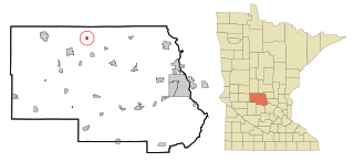
Becker County Minnesota Incorporated and Unincorporated areas Wolf Lake Highlighted.svg
Location of Wolf Lake, Minnesota
Coordinates: 46°48′10″N95°21′8″W / 46.80278°N 95.35222°W / 46.80278; -95.35222
CountryUnited States
State Minnesota
County Becker
Area
[1]
  Total0.32 sq mi (0.83 km2)
  Land0.32 sq mi (0.83 km2)
  Water0.00 sq mi (0.00 km2)
Elevation
1,575 ft (480 m)
Population
 (2020) [2]
  Total71
  Estimate 
(2021) [3]
68
  Density221.88/sq mi (85.80/km2)
Time zone UTC-6 (CST)
  Summer (DST) UTC-5 (CDT)
ZIP code
56593
Area code 218
FIPS code 27-71338 [4]
GNIS feature ID0654321 [5]

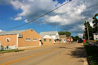
Wolf Lake is a city in Becker County, Minnesota, United States. The population was 71 at the 2020 census. [2]

Contents

Geography

According to the United States Census Bureau, the city has a total area of 0.30 square miles (0.78 km2), all land. [6]

Demographics

Historical population
CensusPop.
1950 109
1960 83−23.9%
1970 58−30.1%
1980 6715.5%
1990 35−47.8%
2000 31−11.4%
2010 5783.9%
2020 7124.6%
2021 (est.)68 [3] −4.2%
U.S. Decennial Census [7]
2020 Census [2]

2010 census

As of the census of 2010, there were 57 people, 22 households, and 13 families living in the city. The population density was 190.0 inhabitants per square mile (73.4/km2). There were 35 housing units at an average density of 116.7 per square mile (45.1/km2). The racial makeup of the city was 96.5% White and 3.5% from two or more races.

There were 22 households, of which 31.8% had children under the age of 18 living with them, 31.8% were married couples living together, 22.7% had a female householder with no husband present, 4.5% had a male householder with no wife present, and 40.9% were non-families. 27.3% of all households were made up of individuals, and 13.6% had someone living alone who was 65 years of age or older. The average household size was 2.59 and the average family size was 3.46.

The median age in the city was 25.3 years. 35.1% of residents were under the age of 18; 14% were between the ages of 18 and 24; 26.3% were from 25 to 44; 15.8% were from 45 to 64; and 8.8% were 65 years of age or older. The gender makeup of the city was 47.4% male and 52.6% female.

2000 census

As of the census of 2000, there were 31 people, 17 households, and 7 families living in the city. The population density was 218.9 inhabitants per square mile (84.5/km2). There were 22 housing units at an average density of 155.4 per square mile (60.0/km2). The racial makeup of the city was 93.55% White, 3.23% Native American, and 3.23% from two or more races.

There were 17 households, out of which 23.5% had children under the age of 18 living with them, 35.3% were married couples living together, and 58.8% were non-families. 52.9% of all households were made up of individuals, and 17.6% had someone living alone who was 65 years of age or older. The average household size was 1.82 and the average family size was 2.71.

In the city, the population was spread out, with 16.1% under the age of 18, 29.0% from 18 to 24, 25.8% from 25 to 44, 16.1% from 45 to 64, and 12.9% who were 65 years of age or older. The median age was 28 years. For every 100 females, there were 106.7 males. For every 100 females age 18 and over, there were 116.7 males.

The median income for a household in the city was $22,083, and the median income for a family was $40,500. Males had a median income of $19,375 versus $21,250 for females. The per capita income for the city was $13,569. There were no families and 7.7% of the population living below the poverty line, including no under eighteens and 33.3% of those over 64.

Related Research Articles

<span class="mw-page-title-main">Skyline, Alabama</span> Town in Alabama, United States

Skyline is a town in Jackson County, Alabama, United States. The town incorporated in 1985. As of the 2010 census, the population of the town was 851, up from 843 in 2000.

<span class="mw-page-title-main">Perryville, Arkansas</span> City in Arkansas, United States

Perryville is a city in and the county seat of Perry County, Arkansas, United States. The population was 1,460 at the 2010 census, an increase of just two persons from 2000. It is part of the Little Rock–North Little Rock–Conway Metropolitan Statistical Area.

<span class="mw-page-title-main">Granite Hills, California</span> Census-designated place in California, United States

Granite Hills is a census-designated place in San Diego County, California. The name is also applied to a neighborhood within the city limits of El Cajon in the eastern part of that city. The population of the CDP, which does not include the people living within the city of El Cajon, was 3,035 at the 2010 census, down from 3,246 at the 2000 census.

<span class="mw-page-title-main">Fort Pierce South, Florida</span> CDP in Florida, United States

Fort Pierce South is a census-designated place (CDP) in St. Lucie County, Florida, United States. The population was 5,062 at the 2010 census. It is part of the Port St. Lucie Metropolitan Statistical Area.

<span class="mw-page-title-main">Franklin, Idaho</span> City in Idaho, United States

Franklin is a city in Franklin County, Idaho, United States. The population was 641 at the 2010 census. It is part of the Logan, Utah-Idaho Metropolitan Statistical Area.

<span class="mw-page-title-main">Kane, Illinois</span> Village in Illinois, United States

Kane is a village in Greene County, Illinois, United States. The population was 438 at the 2010 census.

<span class="mw-page-title-main">Frankfort Square, Illinois</span> Census-designated place in Illinois, United States

Frankfort Square is a census-designated place (CDP) in Will County, Illinois, United States. Per the 2020 census, the population was 8,968. Frankfort Square has a fountain lake near Frankfort Square Road and Saint Francis Road and schools like Lincoln-Way North High School and Summit Hill Junior High.

<span class="mw-page-title-main">Dunreith, Indiana</span> Town in Indiana, United States

Dunreith is a town in Spiceland Township, Henry County, Indiana, United States. The population was 177 at the 2010 census.
<span class="mw-page-title-main">Dixon, Iowa</span> City in Iowa, USA

Dixon is a city in Scott County, Iowa, United States. The population was 202 at the time of the 2020 census.

<span class="mw-page-title-main">Mahaska, Kansas</span> City in Washington County, Kansas

Mahaska is a city in Washington County, Kansas, United States. As of the 2020 census, the population of the city was 46. It is located 1 mile south of the Nebraska state line.

<span class="mw-page-title-main">Bienville, Louisiana</span> Village in Louisiana, United States

Bienville is a village in Bienville Parish, Louisiana, United States. The population was 218 at the 2010 census.

<span class="mw-page-title-main">Lovells Township, Michigan</span> Civil township in Michigan, United States

Lovells Township is a civil township of Crawford County in the U.S. state of Michigan. The population was 626 at the 2010 census.

<span class="mw-page-title-main">Mayville, Michigan</span> Village in Michigan, United States

Mayville is a village in Tuscola County, in the U.S. state of Michigan. The population was 950 at the 2010 census. The village is within Fremont Township along the boundary with Dayton Township.

<span class="mw-page-title-main">Bluffton, Minnesota</span> City in Minnesota, United States

Bluffton is a city in Otter Tail County, Minnesota, United States, along the Leaf River. The population was 210 at the 2020 census.

<span class="mw-page-title-main">Leonidas, Minnesota</span> City in Minnesota, United States

Leonidas is a city in Saint Louis County, Minnesota, United States. The population was 52 at the 2010 census.
<span class="mw-page-title-main">St. Rosa, Minnesota</span> City in Minnesota, United States

Saint Rosa is a city in Stearns County, Minnesota, United States. The population was 68 at the 2010 census. It is part of the St. Cloud Metropolitan Statistical Area.

<span class="mw-page-title-main">Great Bend, North Dakota</span> City in North Dakota, United States

Great Bend is a city in Richland County, North Dakota, United States, on the banks of the Wild Rice River. Its population was 49 at the 2020 census. It was founded in 1888, and incorporated as a village in 1908. It is part of the Wahpeton, ND–MN Micropolitan Statistical Area.

<span class="mw-page-title-main">Lawnton, Pennsylvania</span> Census-designated place in Pennsylvania, United States

Lawnton is an unincorporated area and census-designated place (CDP) in Swatara Township, Dauphin County, Pennsylvania, United States. The population was 3,813 at the 2010 census. It is part of the Harrisburg–Carlisle Metropolitan Statistical Area.

<span class="mw-page-title-main">Kirby, Wyoming</span> Town in Wyoming, United States

Kirby is a town in Hot Springs County, Wyoming, United States.

<span class="mw-page-title-main">Madawaska (CDP), Maine</span> Census-designated place in Maine, United States

Madawaska is a census-designated place (CDP) comprising the main village within the town of Madawaska in Aroostook County, Maine, United States. The population of the CDP was 2,967 at the 2010 census, out of a population of 4,035 for the entire town.

References

  1. "2020 U.S. Gazetteer Files". United States Census Bureau. Retrieved July 24, 2022.
  2. 1 2 3 "Explore Census Data". United States Census Bureau . Retrieved May 8, 2022.
  3. 1 2 "City and Town Population Totals: 2020-2021". United States Census Bureau. September 1, 2022. Retrieved September 1, 2022.
  4. "U.S. Census website". United States Census Bureau . Retrieved January 31, 2008.
  5. "US Board on Geographic Names". United States Geological Survey. October 25, 2007. Retrieved January 31, 2008.
  6. "US Gazetteer files 2010". United States Census Bureau . Retrieved November 13, 2012.
  7. "Census of Population and Housing". Census.gov. Retrieved June 4, 2015.

Coordinates: 46°48′11″N95°21′09″W / 46.80306°N 95.35250°W / 46.80306; -95.35250