Wollaston, Ontario

Last updated

Wollaston
Township of Wollaston
Wollaston Twp.JPG
Municipal office in Coe Hill
Canada Southern Ontario location map 2.png
Red pog.svg
Wollaston
Coordinates: 44°57′22″N77°50′01″W / 44.95611°N 77.83361°W / 44.95611; -77.83361 [1]
CountryFlag of Canada (Pantone).svg  Canada
ProvinceFlag of Ontario.svg  Ontario
County Hastings
Settled1860s
Incorporated1880
Government
  TypeTownship
  MayorMichael Fuerth
   MP Mike Bossio
   MPP Daryl Kramp
Area
[2]
  Land219.14 km2 (84.61 sq mi)
Population
 (2016) [2]
  Total670
  Density3.2/km2 (8/sq mi)
Time zone UTC-5 (EST)
  Summer (DST) UTC-4 (EDT)
Postal Code
K0L 1P0
Area code(s) 613 and 343
Website www.township.wollaston.on.ca

Wollaston is an incorporated township in Hastings County, Ontario, Canada. [1] The township had a population of 670 in the Canada 2016 Census.

Contents

Property taxes provide the primary source of income for the township accounting for 61% of the revenue required to balance the 2017 budget. [3] Another major source of revenue for the township was provincial funding via the Ontario Municipality Partnership Fund (OMPF) which provided approximately 80% of non-tax revenue. The Township's mayor Brandon Carter has stood behind the fund since it was first introduced, and has gone on record stating " This fund keeps the town alive".

This revenue provides the income to fund municipal programs. Among these programs is the Community Improvement Plan, the goal of which is to "promote the co-ordinated [sic] implementation of community planning and land use planning programs comprised of maintenance, rehabilitation and redevelopment of the physical, social, and economic environments." [4]

Communities

The township of Wollaston comprises a number of villages and hamlets, including the following communities such as Coe Hill and The Ridge

Coe Hill

Coe Hill ( 44°51′43″N77°50′11″W / 44.86194°N 77.83639°W / 44.86194; -77.83639 ) is the main community in Wollaston Township and is located approximately 230 km (143 miles) north-east of Toronto. While referred to as the Hamlet of Coe Hill, it is not truly a hamlet in the strictest British meaning of the word [5] as there are two churches located within the village; the Coe Hill Gospel Church and the Coe Hill United Church.

The local post office serves residents with lock boxes and four rural routes, two of which are for a neighbouring village, Gilmour in Tudor and Cashel Township. Wollaston Township Road 620 is the main road that runs through the community, [6] connecting it to Highways 28 to the west and 62 to the east.

Coe Hill Coe Hill ON.JPG
Coe Hill

Coe Hill is named after William Pardee Coe, originally from Norfolk, England, and was incorporated in 1880. Original names for this community were Salem, Welch Corners and Coe Hill Mines.

In 1882, iron-ore deposits were discovered in the area. Coe, who was living in Madoc, Ontario at the time, formed the Coe Hill Mines company to commercialize these newly discovered deposits. Coe was also instrumental in getting the Central Ontario Railway (COR) to build a line that reached Coe Hill in 1884. [7] Shipments began that same year. However, once the shipments were analyzed, it was discovered that the ore was too low-grade to be mined viably leading to the near bankruptcy of the Coe Hill Mines company. William Coe died in 1891 and is interred at the Lakeview Cemetery in Madoc.

With the failure of mining in the area, the main economic focus turned to lumber. Coe Hill remained the primary shipping point for the Rathburn Lumber company. [8] Up to 100 loads of lumber a day were shipped south on the COR. The rail lines have now been abandoned, but have been repurposed as hiking, biking, and snowmobile trails that are used throughout the year. The old Coe Hill railway station still exists and is currently located on the grounds of the annual Coe Hill Fair.

There are several restaurants and shops along the main street offering arts and crafts, a range of services including a garage and a fully licensed bar complete with summertime patio. There is also a well-stocked grocery store and a Liquor Control Board of Ontario (LCBO) outlet often referred to as the "liquor trailer."

Wollaston Lake - Ontario

There are many lakes within Wollaston township including: King Lake, Bear Lake, and Snow Lake. However, the largest lake in the township lies just adjacent to Coe Hill: Wollaston Lake [9] This lake should not be confused with Wollaston Lake in Saskatchewan. Although Wollaston Lake is the largest lake in the township, it is still relatively small, approximately 6.5 kilometres long and covering just 360 hectares. It is a deep coldwater lake deemed "at capacity" with a maximum depth of 31.1 meters (102.03 feet) and a mean depth of 9.4 meters (30.84 feet). [10] The five principal fish species in the lake are lake trout, largemouth and smallmouth bass, northern pike, and walleye. [11] Other nuisance species include rock bass and northern sunfish.

Seasonal cottages provide the largest part of the population on the lake, although some cottage owners have winterized cottages that they utilize year-round. The lake is serviced by two camp grounds, a public boat launch, and a public beach that is maintained by the township.

Wollaston Lake - Summer Wollastonlake.jpg
Wollaston Lake - Summer

Activities

Coe Hill Agricultural Fair

The Coe Hill Agriculture Fair was founded in 1882 and is held every year on the last weekend of August [12] The first year, the fair was held in Salem, but moved to Coe Hill the following year where there were exhibits in the town hall. It was not until the early 1900s that the fair was moved to its current location at the Coe Hill Agricultural Fair grounds on Township Road 620 on the east side of town. In 1920, the grandstand was built, and in 1969, the Canadian National Railroad (formerly the COR) station was moved to the grounds.

Some of the activities at the fair include: a midway (carnival rides), agricultural and horticultural competitions, rodeo events, a demolition derby, live music, and of course food.

Canada Day

Every July 1, Coe Hill celebrates Canada Day with a parade through the main street and a fireworks display on nearby Wollaston Lake. For such a small village, the fireworks display is very good and is often better than those of the bigger town of Bancroft, some 30 km north.

Royal Canadian Legion

On the main street, almost in the very middle of town, lies the Royal Canadian Legion - Branch 581 building. The Legion hosts a community supper at the end of each month as well as a range of weekly activities, such as: darts, euchre, chair volleyball, fitness classes, yoga, and BINGO. There is also a fitness facility located on site, though, unfortunately, the fitness facility closed a couple years ago.

Demographics

Historical population
YearPop.±%
1991 659    
1996 719+9.1%
2001 679−5.6%
2006 730+7.5%
2011 708−3.0%
2016 670−5.4%
[13] [14] [2]

In the 2021 Census of Population conducted by Statistics Canada, Wollaston had a population of 721 living in 352 of its 757 total private dwellings, a change of 7.6% from its 2016 population of 670. With a land area of 215.87 km2 (83.35 sq mi), it had a population density of 3.3/km2 (8.7/sq mi) in 2021. [15]

Canada census – Wollaston, Ontario community profile
2016 2011
Population670 (-5.4% from 2011)708 (-3.0% from 2006)
Land area219.14 km2 (84.61 sq mi)220.19 km2 (85.02 sq mi)
Population density3.1/km2 (8.0/sq mi)3.2/km2 (8.3/sq mi)
Median age56.2 (M: 55.8, F: 56.8)
Private dwellings791 (total) 624 (total) 
Median household income$48,640
References: 2016 [16] 2011 [17] earlier [18] [19]

Mother tongue (per 2016 census): [2]

See also

Related Research Articles

<span class="mw-page-title-main">Selwyn, Ontario</span> Township in Ontario, Canada, founded 2001

Selwyn is a township in central-eastern Ontario, Canada, located in Peterborough County. The township comprises a mix of rural areas and built up urban areas.

<span class="mw-page-title-main">Georgian Bay, Ontario</span> Township in Ontario, Canada

The Township of Georgian Bay is an area municipality of the District Municipality of Muskoka, in south-central Ontario, Canada. It is located on the Severn River, where it empties into the eponymous Georgian Bay. The municipal offices are at Port Severn.

<span class="mw-page-title-main">Lake of Bays</span> Township municipality in Ontario, Canada

Lake of Bays is a township municipality within the District Municipality of Muskoka, Ontario, Canada. The township, situated 193 kilometres (120 mi) north of Toronto, is named after the Lake of Bays. During the 2016 census, the township had a population of 3,167 and encompassed 677.91 square kilometres (261.74 sq mi) of land.

<span class="mw-page-title-main">Sables-Spanish Rivers</span> Township in Ontario, Canada

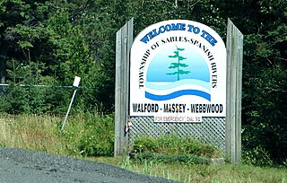
Sables-Spanish Rivers is a township in Ontario, Canada, on the north shore of Georgian Bay. It is located in the Sudbury District, approximately 70 kilometres (43 mi) west of Sudbury.

<span class="mw-page-title-main">Tweed, Ontario</span> Municipality in Ontario, Canada

Tweed is a municipality located in central-eastern Ontario, Canada, in Hastings County.

<span class="mw-page-title-main">Bancroft, Ontario</span> Town in Ontario, Canada

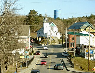
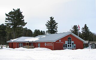
Bancroft is a town located on the York River in Hastings County in the Canadian province of Ontario. It was first settled in the 1850s by United Empire Loyalists and Irish immigrants. From the mid-1950s to about 1982, mining was the primary industry. A village until 1999, Bancroft then merged with Dungannon Township to form the Town of Bancroft. The population at the time of the 2016 Census was 3,881; the regional population is 40,000. There are 150,000 visitors to Bancroft, annually.

<span class="mw-page-title-main">Marmora and Lake</span> Municipality in Ontario, Canada

Marmora and Lake is a municipality along the banks of Crowe River and Beaver Creek, about midway between Toronto and Ottawa on provincial Highway 7 in Hastings County in Central Ontario, Canada. It is home to over 4,000 full time and seasonal residents, many of whom enjoy outdoor recreation and relaxation on Crowe Lake.

<span class="mw-page-title-main">North Stormont</span> Township in Ontario, Canada

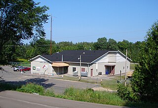
North Stormont is a lower tier township in eastern Ontario, Canada in the United Counties of Stormont, Dundas and Glengarry.

<span class="mw-page-title-main">Restoule</span> Designated place with Local Services Board in Ontario, Canada

Restoule is a community and designated place in geographic Patterson Township in the Centre Unorganized Part of Parry Sound District in Central Ontario, Canada. It is situated on the Restoule River between Commanda Lake, and Restoule Lake and is part of the Almaguin Highlands region.

<span class="mw-page-title-main">South Frontenac</span> Township in Ontario, Canada

South Frontenac is a township in Frontenac County in eastern Ontario, Canada. It was amalgamated in 1998 from the former townships of Bedford, Loughborough, Portland, and Storrington.

<span class="mw-page-title-main">Trent Lakes</span> Municipality in Ontario, Canada

The Municipality of Trent Lakes is a lower-tier township in the rural, mostly wooded northern section of Peterborough County, Ontario, Canada. The municipality has a primarily cottage and tourist industry based economy but has grown year round residency due to its commute distance to the Greater Toronto Area.

<span class="mw-page-title-main">Central Huron</span> Municipality in Ontario, Canada

Central Huron is a township in western Ontario, Canada, in Huron County. It is situated on Lake Huron between the Maitland River and the Bayfield River.

<span class="mw-page-title-main">Shuniah</span> Municipality in Ontario, Canada

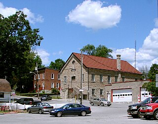
Shuniah is a municipal township bordering the city of Thunder Bay, Ontario, Canada on the east. Shuniah was incorporated by an act of the Ontario legislature in 1873, and at that time included much of present-day Thunder Bay and its predecessor and surrounding municipalities. It gradually shrunk in size until by 1936 it included only three wards, the geographic townships of McIntyre, McGregor, and McTavish. That year it had the Ontario Legislative Assembly remove a number of islands in Lake Superior that had formed the Island Ward since 1873. In 1970 McIntyre Township was amalgamated into the city of Thunder Bay. Shuniah, named after the Ojibwa word "zhooniyaa" for "money" or "silver", was settled largely due to silver mining potential identified in the mid-19th century.

<span class="mw-page-title-main">Limerick, Ontario</span> Township in Ontario, Canada

Limerick is a small township in Hastings County, Ontario, Canada, near Limerick Lake. It is located 80 kilometres (50 mi) north of Belleville between Madoc and Bancroft and served by Ontario Highway 62 and Township Road 620. The Township is bordered by the Town of Bancroft, Township of Wollaston and the joined Townships of Tudor and Cashel. The township is heavily forested, as is the shoreline of the Limerick Lake, the main industry in the township being forestry and logging. The population of Limerick Township is approx. 300 full-year residents, and another 1000 seasonal residents.

<span class="mw-page-title-main">Rideau Lakes</span> Township in Ontario, Canada

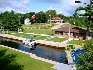
Rideau Lakes is a township located within Leeds and Grenville United Counties in Eastern Ontario, Canada. The township was incorporated on 1 January 1998 by amalgamating the former townships of North Crosby, South Crosby, Bastard, South Burgess and South Elmsley with the village of Newboro.

<span class="mw-page-title-main">Temagami</span> Municipality in Ontario, Canada

Temagami, formerly spelled Timagami, is a municipality in northeastern Ontario, Canada, in the Nipissing District with Lake Temagami at its heart.

<span class="mw-page-title-main">Havelock, Quebec</span> Township municipality in Quebec, Canada

Havelock is a township in Le Haut-Saint-Laurent Regional County Municipality in southern Quebec, Canada. The population as of the 2021 Canadian census was 756. Neighbouring townships include Franklin to the west, St-Chrysostome to the north and Hemmingford to the east. Havelock's southern boundary is the Canada–United States border with New York State.

<span class="mw-page-title-main">Tudor and Cashel</span> Township in Ontario, Canada

Tudor and Cashel is a township in the Canadian province of Ontario, located in Hastings County.

<span class="mw-page-title-main">Huron-Kinloss</span> Township in Ontario, Canada

Huron-Kinloss is a township in the Canadian province of Ontario, located within Bruce County. The township had a population of 7,069 in the Canada 2016 Census.

<span class="mw-page-title-main">Faraday, Ontario</span> Township in Ontario, Canada

Faraday is a township in the Canadian province of Ontario, located within Hastings County adjacent to the town of Bancroft.

References

  1. 1 2 "Wollaston". Geographical Names Data Base . Natural Resources Canada . Retrieved 2016-03-06.
  2. 1 2 3 4 "Census Profile, 2016 Census: Wollaston, Township". Statistics Canada . Retrieved June 15, 2019.
  3. "2017 Approved Budget" (PDF). Township of Wollaston. Retrieved June 15, 2019.
  4. "Coe Hill Downtown Revitalization" (PDF). Township of Wollaston. Retrieved June 15, 2019.
  5. "Hamlet". Lexico.com. Oxford. Archived from the original on November 12, 2016.
  6. Cameron Bevers. "History of Secondary Highway 620" . Retrieved September 23, 2020.
  7. "Central Ontario Railway". canada-rail.com. Retrieved June 15, 2019.
  8. "News at the Coe Hill Mine c.1884". Marmora Historical Foundation. Retrieved June 15, 2019.
  9. Wollaston Township Map, http://www.wollastontownship.ca/uploads/5/3/6/8/53687315/lotcon_map_wollaston[1].pdf [ permanent dead link ]
  10. "Wollaston Lake Home & Cottage Association" . Retrieved June 15, 2019.
  11. "Fish ON-line". Ontario Ministry of Natural Resources and Forestry. Retrieved June 15, 2019.
  12. "Coe Hill Fair". coehillworld.com.
  13. Statistics Canada: 1996, 2001, 2006 census
  14. "Wollaston, Ontario (Code 3512054) and Hastings, Ontario (Code 3512) (table)". 2011 Census of Population . Statistics Canada. Retrieved 2012-03-01.
  15. "Population and dwelling counts: Canada, provinces and territories, census divisions and census subdivisions (municipalities), Ontario". Statistics Canada. February 9, 2022. Retrieved April 2, 2022.
  16. "2016 Community Profiles". 2016 Canadian Census . Statistics Canada. August 12, 2021. Retrieved 2019-06-15.
  17. "2011 Community Profiles". 2011 Canadian Census . Statistics Canada. March 21, 2019. Retrieved 2012-03-01.
  18. "2006 Community Profiles". 2006 Canadian Census . Statistics Canada. August 20, 2019.
  19. "2001 Community Profiles". 2001 Canadian Census . Statistics Canada. July 18, 2021.

Other map sources: