Worksop Rural District

Last updated

Worksop Rural District
Worksop Rural District, Nottinghamshire (1970).svg
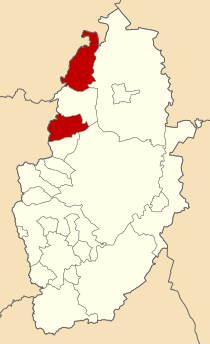
Worksop Rural District shown within Nottinghamshire in 1970.
History
  Created1894
  Abolished1974
  Succeeded by Bassetlaw
Metropolitan Borough of Doncaster
Status Rural District
   HQ Worksop

Worksop (previously Blyth and Cuckney) was a Rural District in Nottinghamshire, England.

It originated as Worksop Rural Sanitary District in 1872. In 1894, under the Local Government Act 1894, the Worksop RSD was split to match county borders, with the West Riding of Yorkshire part becoming the Kiveton Park Rural District, and the Derbyshire part becoming Clowne Rural District.

The remainder, in Nottinghamshire, became the Blyth and Cuckney Rural District, taking its name from two of the parishes, Blyth and Cuckney. In 1925 it was renamed Worksop Rural District.

The district consisted of two detached parts, north and south of the town of Worksop. The northern part contained Blyth; the southern contained Cuckney.

The council initially met at the workhouse. In 1928 it bought Highfield House at 222 Carlton Road to serve as its headquarters. [1]

It was abolished in 1974 under the Local Government Act 1972 and now forms part of the Bassetlaw district, with the exception of small areas that are now part of the Metropolitan Borough of Doncaster.

Related Research Articles

<span class="mw-page-title-main">Bassetlaw District</span> Northernmost district of Nottinghamshire, England

Bassetlaw is a local government district in Nottinghamshire, England. Its council is based in the town of Worksop; the other towns in the district are Retford, Tuxford and Harworth Bircotes. The district also contains numerous villages and surrounding rural areas.

<span class="mw-page-title-main">Bassetlaw (UK Parliament constituency)</span> Parliamentary constituency in the United Kingdom, 1885 onwards

Bassetlaw is a parliamentary constituency in Nottinghamshire, represented in the House of Commons of the UK Parliament since the 2019 general election by Brendan Clarke-Smith, a Conservative. Before that election, the seat had been part of the so-called "red wall", being held by the Labour Party since 1929.

<span class="mw-page-title-main">Bassetlaw Wapentake</span>

Bassetlaw was a wapentake in the English county of Nottinghamshire. The wapentake covered an area in the north of the county, roughly equivalent to the modern Bassetlaw local government district. The wapentake was divided into the divisions of Hatfield, North Clay and South Clay.

Wharfedale was a rural district in the West Riding of Yorkshire from 1894 to 1974. It comprised the northern side of lower Wharfedale, the lower Washburn Valley and several parishes between Leeds and the River Wharfe. Until 1937 it also included a detached part, the parish of Esholt north of Bradford.

Kiveton Park was a rural district in the West Riding of Yorkshire from 1894 to 1974.

<span class="mw-page-title-main">Clowne Rural District</span>

Clowne was a rural district in Derbyshire, England from 1894 to 1974.

Bowland was a rural district in the West Riding of Yorkshire from 1894 to 1974. It was named after the Forest of Bowland, which it included.

South East Derbyshire was a rural district in Derbyshire, England from 1894 to 1974. It covered an area to the south-east of Derby.

Aethwy was a rural district in the administrative county of Anglesey, Wales, from 1894 to 1974.

<span class="mw-page-title-main">Southwell Rural District</span>

Southwell was a rural district in Nottinghamshire, England from 1894 to 1974.

<span class="mw-page-title-main">Newark Rural District</span> Former rural district in Nottinghamshire, England

Newark was a rural district in Nottinghamshire, England from 1894 to 1974.

<span class="mw-page-title-main">East Retford Rural District</span>

East Retford was a rural district in Nottinghamshire, England from 1894 to 1974.

Misterton was a rural district in Nottinghamshire, England from 1894 to 1935.

Leake was a rural district in Nottinghamshire, England from 1894 to 1935.

Skegby was a rural district in Nottinghamshire, England from 1894 to 1935.

<span class="mw-page-title-main">Stapleford Rural District</span>

Stapleford was a rural district in Nottinghamshire, England from 1894 to 1935.

<span class="mw-page-title-main">Blackwell Rural District</span>

Blackwell was a rural district in Derbyshire, England from 1894 to 1974. It was created under the Local Government Act 1894 based on that part of the Mansfield rural sanitary district which was in Derbyshire.

<span class="mw-page-title-main">Gainsborough Rural District</span>

Gainsborough was rural district in Lincolnshire, Parts of Lindsey from 1894 to 1974.

<span class="mw-page-title-main">Hucknall Urban District</span> Former district in Nottinghamshire (1894-1974)

Hucknall was an urban district in Nottinghamshire, England, from 1894 to 1974.

<span class="mw-page-title-main">Norton and Cuckney</span> Civil parish in Bassetlaw, England

Norton and Cuckney is a former civil parish, now in the parish of Norton, Cuckney, Holbeck and Welbeck, in the Bassetlaw district, within the county of Nottinghamshire, England. The overall area had a population of 351 at the 2011 census. The parish lay in the north west of the county, and south west within the district. The parish lies close to the county border with Derbyshire. It is 125 miles north west of London, 20 miles north of the city of Nottingham, and 5 miles north of the market town of Mansfield. The area was bordering Sherwood Forest and has associations with mining interests and the Welbeck Estate.

References

  1. "Interesting presentation at Worksop ceremony". Sheffield Daily Telegraph. 26 July 1928. p. 4. Retrieved 20 December 2023.

53°23′N1°03′W / 53.38°N 1.05°W / 53.38; -1.05