Related Research Articles

West Sussex is a ceremonial county in South East England. It is bordered by Surrey to the north, East Sussex to the east, the English Channel to the south, and Hampshire to the west. The largest settlement is Crawley, and the county town is the city of Chichester.

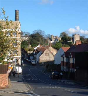
Lancing is a large coastal village and civil parish in the Adur district of West Sussex, England, on the western edge of the Adur Valley. It occupies part of the narrow central section of the Sussex coastal plain between smaller Sompting to the west, larger Shoreham-by-Sea to the east, and the parish of Coombes to the north. Excluding definitive suburbs it may have the largest undivided village cluster in Britain. However, its economy is commonly analysed as integral to the Brighton/Worthing/Littlehampton conurbation. Its settled area beneath the South Downs National Park covers 3.65 square miles, the majority of its land.

Adur is a local government district in West Sussex, England. It is named after the River Adur which flows through the area. The council is based in the town of Shoreham-by-Sea, and the district also contains the town of Southwick, the large village of Lancing and a modest rural hinterland inland. The district had a population of 64,626 at the 2021 census.

Arun is a local government district in West Sussex, England. Its council is based in Littlehampton. The district's other towns are Arundel and Bognor Regis. The district is named after the River Arun, which runs through the centre of the district. Parts of the district fall within the South Downs National Park.
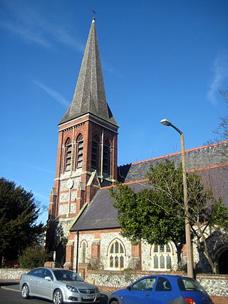
Portslade is a western suburb of the city of Brighton and Hove in the ceremonial county of East Sussex, England. Portslade Village, the original settlement a mile inland to the north, was built up in the 16th century. The arrival of the railway from Brighton in 1840 encouraged rapid development of the coastal area and in 1898 the southern part, formerly known as Copperas Gap, was granted urban district status and renamed Portslade-by-Sea, making it distinct from Portslade Village. After World War II the district of Mile Oak to the north was added. Today, Portslade is bisected from east to west by the old A27 road between Brighton and Worthing, each part having a distinct character.

Sompting is a village and civil parish in the coastal Adur District of West Sussex, England between Lancing and Worthing. It is half grassland slopes and half developed plain at the foot of the South Downs National Park. Twentieth-century estates dovetail into those of slightly larger Lancing.
Shoreham was a parliamentary constituency centred on the town of Shoreham-by-Sea in West Sussex. It returned one Member of Parliament (MP) to the House of Commons of the Parliament of the United Kingdom from 1974 to 1997.

Botolphs, is a village and former civil parish, located in the parish of Bramber, in the Horsham District of West Sussex, England. It is in the Adur Valley 1.5 miles (2.4 km) southeast of Steyning on the road between Steyning and Coombes. Botolphs lies on the South Downs Way long-distance footpath. In 1931 the parish had a population of 64. On 1 April 1933 the parish was abolished and merged with Bramber.

Broadwater is a neighbourhood of Worthing, in the borough of Worthing in West Sussex, England. Situated between the South Downs and the English Channel, Broadwater was once a parish in its own right and included Worthing when the latter was a small fishing hamlet. Before its incorporation into the Borough of Worthing in 1902 Broadwater also included the manor of Offington to the north. It borders Tarring to the west, Sompting to the east, and East Worthing to the south-east.
West Worthing is a neighbourhood of Worthing in West Sussex, England that was developed within Heene and later expanded beyond Heene's boundaries. Intended as an exclusive resort, the township of West Worthing was developed from around 1864 and merged with the formerly separate township of Worthing in 1890, when Worthing gained borough status.

Worthing Borough Council is the local authority for Worthing in West Sussex, England. Worthing is a non-metropolitan district with borough status. It forms the lower tier of local government in Worthing, responsible for local services such as housing, planning, leisure and tourism. The council is currently led by the Labour Party. It is based at Worthing Town Hall.
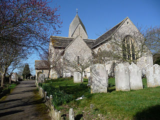
The Church of St Mary the Blessed Virgin, also known as St Mary the Virgin Church and St Mary's Church, is the Church of England parish church of Sompting in the Adur district of West Sussex. It stands on a rural lane north of the urban area that now surrounds the village, and retains much 11th- and 12th-century structure. Its most important architectural feature is the Saxon tower topped by a Rhenish helm, a four-sided pyramid-style gabled cap that is uncommon in England. English Heritage lists the church at Grade I for its architecture and history.

Sompting & North Lancing is an electoral division of West Sussex in the United Kingdom, and returns one member to sit on the West Sussex County Council.

St James the Less Church is the Anglican parish church of Lancing, an ancient village which has been absorbed into the modern town of Lancing in the district of Adur, one of seven local government districts in the English county of West Sussex. It was founded in the 12th century in the most northerly of the three settlements in Lancing parish, which has Saxon origins. The present building is mostly 13th-century in appearance, and structural work has been carried out several times since—particularly in the 18th and 19th centuries, when the church was restored from a ruinous condition. English Heritage has listed the church at Grade I for its architectural and historical importance.
The district of Adur, one of seven local government districts in the English county of West Sussex, has 119 buildings with listed status. The urbanised southern part of the district forms part of the Brighton/Worthing/Littlehampton conurbation, and most listed structures are in the three main centres of population: Southwick, Shoreham-by-Sea and Lancing. The towns have grown residentially and industrially in the 20th century, but all three have ancient origins as villages and manors on the banks of the River Adur and the English Channel coast. The rest of Adur district's territory is remote downland countryside with scattered farms and hamlets; some of their buildings also have listed status.
Crawley Borough Council is the local authority for Crawley in West Sussex, England. It consists of 36 councillors and is currently controlled by the Labour Party, led by Michael Jones. The administrative headquarters are at Crawley Town Hall.
The history of local government in Sussex is unique and complex. Founded as a kingdom in the 5th century, Sussex was annexed by the kingdom of Wessex in the 9th century, which after further developments became the Kingdom of England. It currently corresponds to two counties, East Sussex and West Sussex.
Sompting Abbotts Preparatory School is a historic West Sussex independent school in Sompting, near Worthing and Steyning. It educates children of both sexes aged 2 to 13. The school sits in parkland of 30 acres, which includes woodland, chalk grassland slopes and a pond.
References
- 1 2 "Records of East Preston Union". The National Archives . Retrieved 12 February 2020.
- ↑ "Worthing RD: Relationships unit history of Worthing RD". A Vision of Britain. University of Portsmouth. Retrieved 20 January 2010.
- ↑ "Worthing RD: Relationships unit history of Worthing RD". A Vision of Britain. University of Portsmouth. Retrieved 20 January 2010.
- ↑ "Worthing RD: Relationships unit history of Worthing RD". A Vision of Britain. University of Portsmouth. Retrieved 20 January 2010.
50°51′07″N0°28′50″W / 50.85191°N 0.48065°W
| | This West Sussex location article is a stub. You can help Wikipedia by expanding it. |