The history of local government in Sussex is unique and complex. Founded as a kingdom in the 5th century, Sussex was annexed by the kingdom of Wessex in the 9th century, which after further developments became the Kingdom of England. It currently corresponds to two counties, East Sussex and West Sussex.
After the Reform Act 1832 Sussex was divided for purposes of administration into an eastern and a western division; these divisions were coterminous with the two archdeaconries of Chichester and Lewes[1] and also the three eastern and three western county subdivisions respectively. In 1889, following the Local Government Act 1888, using those same boundaries, Sussex was divided into two administrative counties, East Sussex and West Sussex, together with two self-governing county boroughs, Brighton and Hastings, later joined by Eastbourne. In 1974, under the Local Government Act 1972, the county boundaries were revised with the mid-Sussex areas of East Grinstead, Haywards Heath, Burgess Hill and Hassocks being transferred from the administrative area of East Sussex into that of West Sussex, along with the Gatwick area that historically has been part of Surrey. The county boroughs were returned to the control of the two county councils but in 1997 the towns of Brighton and Hove were amalgamated as a unitary local authority and in 2000, Brighton and Hove was given city status.[2]
There continue to be a range of organisations that operate across the entirety of Sussex, even though it is administered as two non-metropolitan counties of East and West Sussex. Organisations providing public services to across Sussex include Sussex Police, NHS Sussex, and the Sussex Inshore Fisheries and Conservation Authority. Sussex is recognised as a single cultural region, significant in culture and sport and is used by a range of organisations as a regional unit.
Saxon period
Sussex and the other main Anglo-Saxon kingdoms at about AD600
Sussex originated in the 5th century as the Kingdom of Sussex, which in the 9th century was annexed by the Kingdom of Wessex, which with further expansions became the Kingdom of England. While Sussex retained its independence it is likely that it would have had a regular assembly or folkmoot.[3]
Sussex seems to have had a greater degree of decentralisation than other kingdoms.[4] For a period during the 760s there may have been as many as four of five kings based within the territory, perhaps with each ruling over a distinct tribal territory,[5] perhaps on a temporary basis.[6] It seems possible that the people of the Haestingas may have had their own ruler for a while, and another sub-division may have been along the River Adur.[6]
At some stage in the Saxon period Sussex was divided into administrative areas which became known as 'rapes'. It is possible that the rapes represent the shires of the ancient kingdom of Sussex, especially as in the 12th century they had sheriffs of their own.[7] Another possibility is that the rapes may derive from the system of fortifications, or burhs (boroughs) devised by Alfred the Great in the late ninth century to defeat the Vikings.
Various local folkmoots would have been held in Sussex, for instance at Ditchling,[8] Tinhale (in Bersted) and Madehurst. Placename evidence for early assemblies in Sussex comes from Tinhale (from the Old English þing (thing) meaning hold a meeting, so 'meeting-hill') and Madehurst (from the Old English maedel meaning assembly, so 'assembly wooded hill').[9] There is also a location in Durrington that had the name gemot biorh meaning a moot barrow or meeting barrow, a boundary barrow.[10]
The early hundreds often lacked the formality of later attempts of local government: frequently they met in the open, at a convenient central spot, perhaps marked by a tree, as at Easebourne. Dill, meaning the boarded meeting place, was one of the few hundreds in Sussex that provided any accommodation.[11] From the 10th century onwards the hundred became important as a court of justice as well as dealing with matters of local administration.[12] The meeting place was often a point within the hundred such as a bridge (as in the bridge over the western River Rother in Rotherbridge hundred) or a notable tree (such as a tree called Tippa's Oak in Tipnoak hundred).[12]
Late medieval period
At the time of the Norman Conquest there were four rapes: Arundel, Lewes, Pevensey and Hastings. By the time of the Domesday Book, William the Conqueror had created the Rape of Bramber out of parts of the Arundel and Lewes rapes, so that the Adur estuary could be better defended.[13][14][15] Between 1250 and 1262, the rape of Chichester was created from the western half of Arundel rape.[14] From this time onwards, Sussex was divided into—from west to east—Chichester, Arundel, Bramber, Lewes, Pevensey and Hastings rapes.
Although the origin and original purpose of the rapes is not known, their function after 1066 is clear. With its own lord and sheriff, each rape was an administrative and fiscal unit.[16]
Early modern period
17th century map by Wenceslas Hollar showing the six Rapes of Sussex, including the Rape of Chichester, which existed from the 13th century
Administering such an extensive county as Sussex as a single unit had proved difficult: the traditional meeting of the court of quarter sessions at Chichester in the south-west was a long distance from much of the county's population and no single venue met the needs of such a diverse county. A statute of 1504 created a system where the sheriff's court alternated between Chichester and Lewes. By the 1590s every administrative arrangement within local control respected the subdivision of the county[17] into an eastern division, made up of the rapes of Hastings, Lewes and Pevensey, and a western division, made up of the rapes of Arundel, Bramber and Chichester.
Sussex hosted seven rather than the usual four quarter sessions. During the assigned weeks for Epiphany, Easter and Michaelmas, one court convened at the western section of Sussex on Mondays and Tuesdays and another court convened in the eastern section on Thursdays and Fridays.[18] The western meetings followed a geographical rotation between Chichester, Petworth, Arundel and Midhurst; the eastern sessions always took place at Lewes. The Midsummer quarter session took place for the whole of Sussex at either East Grinstead or Horsham. By the reign of Elizabeth I the quarter sessions for eastern and western Sussex were effectively independent and the office of the Clerk of the Peace was the sole administrative link between the two.[18]
The rapal courts continued to meet and stewards for the rapes were recorded into the 18th century.[19]
19th century
This boundary stone in the centre of Tunbridge Wells marks the historic boundary between Sussex and Kent; after the Local Government Act 1894 the south of Tunbridge Wells and the south of Lamberhurst were administered as part of Kent
Between 1834 and 1930 poor law unions existed for administration of poor law relief. In 1860 the north of parish of Frant in the Rape of Pevensey became part of the Tunbridge Wells Local Government District.
Together with several other counties (Cambridgeshire, Lincolnshire, Northamptonshire, Suffolk and Yorkshire) Sussex was for administrative purposes divided into an eastern division and a western division. An informal arrangement for several centuries, the division of Sussex for administrative purposes was formally confirmed through the County of Sussex Act 1865. In 1889 county councils were created for the eastern and western divisions and county boroughs were created as part of the Local Government Act 1888. The rapes of Arundel, Bramber and Chichester comprised Sussex's western division and the rapes of Lewes, Pevensey and Hastings comprised the eastern division, with the exclusion of the large towns of Brighton and Hastings which became county boroughs. Sussex continued to be classed as a single county under the act and retained a single lieutenancy and shrievalty.
Map of Sussex in 1851 showing the six Rapes
In 1894 and 1895 minor boundary alterations between Sussex and Kent were made by the Local Government Board. The parish of Frant, which had lain within both counties was split with the Kent portions becoming the parishes of Broadwater Down (the southern area of Tunbridge Wells) and Tonbridge Rural. In 1895 Lamberhurst south of the River Teise transferred to Kent, while the Kent portions of Horsemonden and Broomhill were transferred to Sussex.[20][21][22][23]
Sub-division
Rapes
Top tier local authorities in 1889
Changes to top tier local authorities 1889-1974
Eastern
Hastings, Lewes, Pevensey
East Sussex (administrative county), Brighton, Hastings (county boroughs)
Boundary changes in 1894, 1895, 1897, 1900, 1909, 1926, 1928, 1938, 1952 and 1953.[24] Eastbourne became county borough in 1911.
Western
Arundel, Bramber, Chichester,
West Sussex (administrative county)
Boundary changes in 1894, 1895, 1908 and 1953.[24]
In 1894 the remainder of each administrative county, that was not a county borough or municipal ('non-county') borough, was divided into urban and rural districts by the Local Government Act 1894 (56 & 57 Vict. c. 73). A new county borough for Eastbourne was created in 1911.
Local government districts 1894-1974
The local government districts created in 1894 remained largely unchanged until the 1930s. The Local Government Act 1929 and Local Government Act 1933 gave county councils to carry out reviews and eliminate smaller districts and carry out amalgamations to provide more effective council areas. Changes were made in West Sussex in 1933 and in East Sussex in 1934.
East Sussex
District
Changes
Battle Rural District
Absorbed Battle Urban District, Hastings Rural District, Rye Rural District, most of Ticehurst Rural District in 1934
Battle Urban District
Absorbed by Battle Rural District 1934
Bexhill Urban District
Incorporated as Borough of Bexhill-on-Sea 1902
Burgess Hill Urban District
Chailey Rural District
Absorbed Newhaven Rural District 1934
Cuckfield Rural District
Included one parish in West Sussex (Albourne) until 1908 when the parish was moved into East Sussex. Absorbed part of East Grinstead Rural District 1934
Cuckfield Urban District
Absorbed Haywards Heath Urban District 1934
Eastbourne Borough
Created a county borough in 1911
Eastbourne Rural District
Absorbed by Hailsham Rural District 1934
East Grinstead Rural District
Absorbed by Cuckfield and Uckfield Rural Districts 1934
East Grinstead Urban District
Hailsham Rural District
Absorbed Eastbourne Rural District 1934
Hastings Rural District
Absorbed by Battle Rural District 1934
Haywards Heath Urban District
Absorbed by Cuckfield Urban District 1934
Hove Urban District
Incorporated as a borough in 1898. Absorbed part of Steyning East Rural District 1928
Lewes Borough
Newhaven Rural District
Absorbed by Chailey Rural District 1934
Newhaven Urban District
Portslade by Sea Urban District
Created 1898 from part of Steyning East Rural District
Rye Borough
Rye Rural District
Absorbed by Battle Rural District 1934
Seaford Urban District
Steyning East Rural District
Abolished 1928: part to Brighton County borough, part to Hove Borough, part to Cuckfield Rural District 1928
Ticehurst Rural District
Abolished 1934, most to Battle Rural District, Part to Uckfield Rural District
Uckfield Rural District
Absorbed Uckfield Urban District, part of East Grinstead Rural District, part of Ticehurst Urban District 1934
West Sussex
District
Changes
Arundel Borough
Bognor Urban District
Renamed Bognor Regis Urban District 1929
Chanctonbury Rural District
Formed 1933 from parts of abolished Steyning West Rural District, Thakenham Rural District
Chichester City (Borough)
Chichester Rural District
Formed 1933 from parts of abolished East Preston Rural District, Westbourne Rural District, Westhampnett Rural District
Crawley Urban District
Created 1956 from part of Horsham Rural District
Cuckfield Rural District (part only)
One West Sussex parish (Albourne) was in the rural district. In 1908 the parish was transferred to East Sussex and Cuckfield RD was entirely in that county.
East Preston Rural District
Abolished 1933, most went to form Worthing Rural District, part to Chichester Rural District
Horsham Rural District
Parish of Crawley became a separate urban district 1956
Horsham Urban District
Littlehampton Urban District
Midhurst Rural District
New Shoreham Urban District
Became part of Shoreham-by-Sea Urban district 1910
Petworth Rural District
Shoreham-by Sea Urban District
Formed 1910 from New Shoreham Urban District and part of Steyning West Rural District (Kingston by Sea). Enlarged 1933 by addition of Old Shoreham when Steyning West Rural District abolished
Southwick Urban District
Formed 1899 from part of Steyning West Rural District
Thakenham Rural District
Abolished 1933. Most of area went to form Chanctonbury Rural District, part to Worthing Rural District
Westbourne Rural District
Abolished 1933, area went to form part of Chichester Rural District
Westhampnett Rural District
Abolished 1933. Became part of new Chichester Rural District
Created from parts of abolished East Preston Rural District, Thakenham Rural District
Changes in 1974
Local government in England was reformed in 1974 by the Local Government Act 1972.[25] Under the act, the ridings lost their lieutenancies and shrievalties and the administrative counties, county boroughs and their councils were abolished.[26] The area of Sussex was divided between a number of non-metropolitan counties:[27]
The non-metropolitan counties became counties for purposes such as lieutenancy.[26]
The urban districts of Burgess Hill, Cuckfield and East Grinstead, and nearly all of Cuckfield Rural District were transferred to the new district of Mid Sussex, while the remainder of Cuckfield Rural District was transferred to the borough of Crawley; both areas were transferred from the jurisdiction of East Sussex to that of West Sussex. Mid Sussex's change in county was argued under the Redcliffe-Maud Report's Planning Area enhancing a Second Wilson ministry plan with support from locally resident Lords and of the Heath ministry. Under this plan West Sussex gained an irregular swathe of East Sussex as far as East Grinstead in the north and in its initially passed form, Crawley would have gained two parishes in Surrey instead of the Gatwick part of these. The proposals met with some protest, a 1971 demonstration by 1,500 residents disrupted traffic on the main London to Brighton road at the proposed boundary.[28] The changes were mostly reversed due to a local poll before its 1974 implementation, with the Charlwood and Horley Act 1974. East to West Sussex land re-designation was kept with the stated aim of uniting all areas affected by the projected major Crawley and Gatwick Airport economy under one supervisory local authority.[29]
Royal Mail reaction
The Royal Mail adopted East and West Sussex as postal counties in 1974. Postal counties are no longer in official use.[30]
1990s local government reform
A review of local government took place during the 1990s which made a number of changes to the counties created in 1974. Brighton regained its unitary status lost in 1974 by joining with the borough of Hove to form Brighton and Hove in 1997. Brighton and Hove subsequently attained city status in 2001.
In 2020, East Sussex and West Sussex County Councils started sharing their chief executive, Becky Shaw.[35]
Calls for devolution
Cultural historian Peter Brandon has called the current division of Sussex into east and west 'unnatural' and advocates the reunification of East and West Sussex[36] while historian Chris Hare has called for a devolved regional assembly for Sussex.[37]Brighton KemptownMP, Lloyd Russell-Moyle has also called for a tax-raising Sussex Parliament, with similar powers to the Welsh Senedd, and for regional representation for Sussex in a reformed House of Lords.[38][39][40]
Two devolution proposals involving Sussex local authorities were submitted to the UK Government in 2015. One proposal involved East and West Sussex County Councils together with Surrey County Council and district and borough councils. Another proposal involved the city of Brighton and Hove as well as Adur, Lewes, Mid Sussex and Worthing, which agreed the Greater Brighton City Deal in 2014.
Sussex is an area and cultural region within South East England which was historically a kingdom and later a county. It includes the ceremonial counties of East Sussex and West Sussex.
East Sussex is a ceremonial county in South East England. It is bordered by Kent to the north-east, West Sussex to the west, Surrey to the north-west, and the English Channel to the south. The largest settlement is the city of Brighton and Hove, and the county town is Lewes.
West Sussex is a ceremonial county in South East England. It is bordered by Surrey to the north, East Sussex to the east, the English Channel to the south, and Hampshire to the west. The largest settlement is Crawley, and the county town is the city of Chichester.
The A27 is a major road in England. It runs from its junction with the A36 at Whiteparish in the county of Wiltshire, follows the south coast of Hampshire and West Sussex, and terminates at Pevensey in East Sussex.
The A259 is a road on the south coast of England passing through Hampshire, West Sussex, East Sussex, and Kent, and is the longest Zone 2 A road in Great Britain. The main part of the road connects Brighton, Eastbourne, Hastings, Rye, and Folkestone.
A rape is a traditional territorial sub-division of the county of Sussex in England, formerly used for various administrative purposes. Their origin is unknown, but they appear to predate the Norman Conquest. Historically the rapes formed the basis of local government in Sussex.
Sussex, from the Old English 'Sūþsēaxe', is a historic county in South East England.
Sussex Police are the territorial police force responsible for policing in the whole of Sussex. Their jurisdiction covers the ceremonial counties of East Sussex and West Sussex. Their headquarters are in Malling House, Lewes, East Sussex.
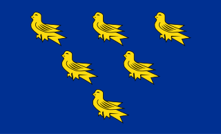
A heraldic shield has been associated with the historic county of Sussex since the seventeenth century. The device, displaying six martlets or heraldic swallows on a shield, later formed the basis of the flag of Sussex and the armorial bearings granted to the county councils of East and West Sussex.
East Sussex County Council is the upper tier local authority for the non-metropolitan county of East Sussex in England.
Sussex is a historic county and cultural region in the south of England corresponding roughly in area to the ancient Kingdom of Sussex. It is bounded on the north by Surrey, north-east by Kent, south by the English Channel, and west by Hampshire, and is divided for local government into West Sussex and East Sussex and the city of Brighton and Hove. The city of Brighton & Hove was created a unitary authority in 1997, and was granted City status in 2000. Until then Chichester had been Sussex's only city. By convention, Chichester is Sussex's capital city and Lewes is Sussex's county town.
The Rape of Bramber is one of the rapes, the traditional sub-divisions unique to the historic county of Sussex in England. It is the smallest Sussex rape by area. Bramber is a former barony whose original seat was the castle of Bramber and its village, overlooking the river Adur.
The Rape of Lewes is one of the rapes, the traditional sub-divisions unique to the historic county of Sussex in England.
Healthcare in Sussex is the responsibility of NHS Sussex, an integrated care system and the NHS Sussex Partnership NHS Foundation Trust.
Religion in Sussex has been dominated over the last 1,400 years by Christianity. Like the rest of England, the established church in Sussex is the Church of England, although other Christian traditions exist. After Christianity, the religion with the most adherents is Islam, followed by Hinduism, Buddhism, Judaism and Sikhism.
The history of Christianity in Sussex includes all aspects of the Christianity in the region that is now Sussex from its introduction to the present day. Christianity is the most commonly practised religion in Sussex.
Sussex in the High Middle Ages includes the history of Sussex from the Norman Conquest in 1066 until the death of King John, considered by some to be the last of the Angevin kings of England, in 1216. It was during the Norman period that Sussex achieved its greatest importance in comparison with other English counties. Throughout the High Middle Ages, Sussex was on the main route between England and Normandy, and the lands of the Anglo-Norman nobility in what is now western France. The growth in Sussex's population, the importance of its ports and the increased colonisation of the Weald were all part of changes as significant to Sussex as those brought by the neolithic period, by the Romans and the Saxons. Sussex also experienced the most radical and thorough reorganisation of land in England, as the Normans divided the county into five tracts of lands called rapes. Although Sussex may have been divided into rapes earlier in its history, under the Normans they were clearly administrative and fiscal units. Before the Norman Conquest Sussex had the greatest concentration of lands belonging to the family of Earl Godwin. To protect against rebellion or invasion, the scattered Saxon estates in Sussex were consolidated into the rapes as part of William the Conqueror's 'Channel march'.
References
↑ Horsfield. The History, Antiquities and Topography of the County of Sussex. Volume II. Appendix pp. 23–75.
↑ John Godfrey. "Local Government in the 19th and 20th Century". In An Historical Atlas of Sussex. pp. 126–127.
↑ Turner, George James (1911). "Rape (division)". In Chisholm, Hugh (ed.). Encyclopædia Britannica. Vol.22 (11thed.). Cambridge University Press. p.900; see lines ten to twelve. It is possible that the rapes represent the shires of the ancient kingdom of Sussex, especially as in the 12th century they had sheriffs of their own.
Grehan, John; Mace, Martin (2012). Battleground Sussex. Casemate Publishers. ISBN978-1848846616.
Hare, Chris (1995). A History of the Sussex People. Worthing: Southern Heritage Books. ISBN978-0-9527097-0-1.
Herrup, Cynthia B. (1989). The Common Peace: Participation and he Criminal Law in Seventeenth-Century England. Cambridge University Press. ISBN978-0521375870.
Lapidge, Michael; Blair, John; Keynes, Simon; Scragg, Donald (2013). The Wiley Blackwell Encyclopedia of Anglo-Saxon England. Wiley. ISBN9780470656327.
Lowerson, John (1980). A Short History of Sussex. Folkestone: Dawson Publishing. ISBN0-7129-0948-6.
Semple, Sarah (2013). Perceptions of the Prehistoric in Anglo-Saxon England: Religion, Ritual and Rulership in the Landscape. Oxford: Oxford University Press. ISBN978-0199683109.
Stubbs, William (1874). A Constitutional History of England in its Origin and Development, Volume 1. Clarendon Press.
This page is based on this Wikipedia article Text is available under the CC BY-SA 4.0 license; additional terms may apply. Images, videos and audio are available under their respective licenses.