
Sussex is a cultural region of England on the nation's south coast. The region is characterised by its various types of steep sharp chalk hills landscapes known as downland or collectively as the Weald, part of the region's landscape is in the South Downs National Park.

West Sussex is a ceremonial county in South East England. It is bordered by Surrey to the north, East Sussex to the east, the English Channel to the south, and Hampshire to the west. The largest settlement is Crawley, and the county town is the city of Chichester.

A rape is a traditional territorial sub-division of the county of Sussex in England, formerly used for various administrative purposes. Their origin is unknown, but they appear to predate the Norman Conquest. Historically the rapes formed the basis of local government in Sussex.
Sussex, from the Old English 'Sūþsēaxe', is a historic county in South East England.

Earnley is a village and a civil and ecclesiastical parish in the Chichester District of West Sussex, England. It is located four miles (6.4 km) south-west of Chichester, and lies on the south coast of England. The parish includes the settlements of Almodington and Batchmere.

Poling is a village and civil parish in the Arun District of West Sussex, England, 2 miles (3.2 km) southeast of Arundel on a minor road south of the A27. About 25% of the parish is wooded foothill slopes of the South Downs which is the area north of the A27 here.
Walberton is a village and civil parish in the Arun District of West Sussex, England, 5 miles (8 km) north-west of Littlehampton, and south of the A27 road. The land rises from 33–115 feet (10–35 m) above sea level, a quarter of the height of Nore Hill, the nearest foothill of the South Downs, which is to the north of the parish. The parish includes the smaller village of Binsted to the east and the larger neighbourhood of Fontwell, less than two-thirds of a mile (1 km) to the north-west. Walberton has a medieval church next to its clustered centre. Binsted's medieval church retains an original setting of village houses dispersed over farm fields.

Yapton is a village and civil parish in the Arun District of West Sussex, England. It is centred three miles (4.8 km) north east of Bognor Regis at the intersection of the B2132 and B2233 roads.

The Rape of Bramber is one of the rapes, the traditional sub-divisions unique to the historic county of Sussex in England. It is the smallest Sussex rape by area. Bramber is a former barony whose original seat was the castle of Bramber and its village, overlooking the river Adur.

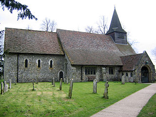
St Mary's Church is an Anglican church in the village of Walberton in the district of Arun, one of seven local government districts in the English county of West Sussex. Its 11th-century origins are now mostly hidden behind the results of extensive restoration work undertaken since the 18th century; but some Saxon-era fragments remain, and reused Roman building materials can still be seen in the walls. The extensive collection of 18th-century gravestones in the churchyard includes some especially macabre examples. The church is protected as a Grade I Listed building.

The present Angmering Baptist Church and its predecessor building, known as Church of Christ, are respectively the current and former Baptist places of worship in Angmering, a village in the Arun district of West Sussex, England. Baptist worship in the area can be traced back to 1846, when the "strangely towered" Church of Christ was founded and built. After the Gothic-style chapel became unsuitable for modern requirements, the congregation acquired a nearby barn and converted it into a new church, after which the old building was sold for residential conversion. The church has been designated a Grade II listed building.

The Rape of Chichester is one of the rapes, the traditional sub-divisions unique to the historic county of Sussex in England. The most westerly of the Sussex rapes, the rape of Chichester is a former barony, originally centred on Chichester Castle in the city of Chichester.

The Rape of Lewes is one of the rapes, the traditional sub-divisions unique to the historic county of Sussex in England.

The Rape of Pevensey is one of the rapes, the traditional sub-divisions unique to the historic county of Sussex in England. With an area of 228,930 acres (926.4 km2) it is the largest of the Sussex rapes.

The Rape of Hastings is one of the rapes, the traditional sub-divisions unique to the historic county of Sussex in England.
The history of local government in Sussex is unique and complex. Founded as a kingdom in the 5th century, Sussex was annexed by the kingdom of Wessex in the 9th century, which after further developments became the Kingdom of England. It currently corresponds to two counties, East Sussex and West Sussex.

Arundel and District Hospital is a health facility in Chichester Road, Arundel, West Sussex, England. It is managed by the Sussex Community NHS Foundation Trust.

Yapton Free Church is an Evangelical church in the village of Yapton in West Sussex, England. The "pretty flint building" dates from 1861, when it was built for a group of Congregational worshippers who had been active in the area for several years. Growth in membership during the 20th century meant that by the 1990s some services and activities were held in larger premises elsewhere, but the chapel remains registered as a place of worship. The church is denominationally independent but is associated with a worldwide cross-denomination network of churches called Partners in Harvest. The church building has been listed at Grade II by Historic England for its architectural and historical importance.