Wynnedale, Indiana

Last updated

Wynnedale, Indiana
Knollton Road, Wynnedale, Indiana.jpg
Marion County Indiana Incorporated and Unincorporated areas Wynnedale Highlighted 1885742.svg
Location in Marion County, Indiana
Coordinates: 39°49′57″N86°12′01″W / 39.83250°N 86.20028°W / 39.83250; -86.20028
Country United States
State Indiana
County Marion
Township Washington
Area
[1]
  Total0.16 sq mi (0.41 km2)
  Land0.16 sq mi (0.41 km2)
  Water0.00 sq mi (0.00 km2)
Elevation
[2]
742 ft (226 m)
Population
 (2020) [3]
  Total215
  Density1,352.20/sq mi (520.63/km2)
Time zone UTC-5 (Eastern (EST))
  Summer (DST) UTC-4 (EDT)
ZIP Code
46228
Area code 317
FIPS code 18-85742 [4]
GNIS feature ID2397757 [2]
Website www.wynnedale.org

Wynnedale is a town in Washington Township, Marion County, Indiana, United States. The population was 215 at the 2020 census. [3] It has existed as an "included town" since 1970, when it was incorporated into Indianapolis as part of Unigov. It is part of Indianapolis, but retains a functioning town government under IC 36-3-1-11. [5]

Contents

Geography

Sign welcoming people to Wynnedale Welcome to Wynnedale.jpg
Sign welcoming people to Wynnedale

Wynnedale is located 5 miles (8 km) northwest of downtown Indianapolis. [6] It is bordered to the east by the town of Spring Hill.

According to the U.S. Census Bureau, Wynnedale has a total area of 0.16 square miles (0.41 km2), all land. [1]

Demographics

Historical population
CensusPop.Note
1940 60
1950 7525.0%
1960 174132.0%
1970 124−28.7%
1980 289133.1%
1990 269−6.9%
2000 2752.2%
2010 231−16.0%
2020 215−6.9%
U.S. Decennial Census [7]

2010 census

As of the census [8] of 2010, there were 231 people, 96 households, and 71 families living in the town. The population density was 1,443.8 inhabitants per square mile (557.5/km2). There were 99 housing units at an average density of 618.8 per square mile (238.9/km2). The racial makeup of the town was 61.0% White, 35.9% African American, 1.3% Asian, 0.4% from other races, and 1.3% from two or more races. Hispanic or Latino of any race were 0.9% of the population.

There were 96 households, of which 26.0% had children under the age of 18 living with them, 67.7% were married couples living together, 6.3% had a female householder with no husband present, and 26.0% were non-families. 21.9% of all households were made up of individuals, and 13.5% had someone living alone who was 65 years of age or older. The average household size was 2.41 and the average family size was 2.83.

The median age in the town was 52.4 years. 19.9% of residents were under the age of 18; 1.3% were between the ages of 18 and 24; 14.2% were from 25 to 44; 39% were from 45 to 64; and 25.5% were 65 years of age or older. The gender makeup of the town was 48.1% male and 51.9% female.

2000 census

As of the census [4] of 2000, there were 275 people, 108 households, and 84 families living in the town. The population density was 1,643.6 inhabitants per square mile (634.6/km2). There were 112 housing units at an average density of 669.4 per square mile (258.5/km2). The racial makeup of the town was 64.73% White, 33.09% African American, 0.36% Native American, 0.36% Asian, 1.45% from other races. Hispanic or Latino of any race were 1.45% of the population.

There were 108 households, out of which 31.5% had children under the age of 18 living with them, 67.6% were married couples living together, 7.4% had a female householder with no husband present, and 22.2% were non-families. 20.4% of all households were made up of individuals, and 8.3% had someone living alone who was 65 years of age or older. The average household size was 2.55 and the average family size was 2.82.

In the town, the population was spread out, with 21.1% under the age of 18, 3.6% from 18 to 24, 22.2% from 25 to 44, 32.7% from 45 to 64, and 20.4% who were 65 years of age or older. The median age was 48 years. For every 100 females, there were 111.5 males. For every 100 females age 18 and over, there were 104.7 males.

The median income for a household in the town was $93,778, and the median income for a family was $101,931. Males had a median income of $80,969 versus $32,344 for females. The per capita income for the town was $50,323. None of the families and 0.9% of the population were living below the poverty line, including no under eighteens and 4.5% of those over 64.

Related Research Articles

<span class="mw-page-title-main">Jamestown, Indiana</span> Town in Indiana, United States

Jamestown is a town in Jackson Township, Boone County and Eel River Township, Hendricks County, Indiana, United States. The population was 958 at the 2010 census.

<span class="mw-page-title-main">Michigantown, Indiana</span> Town in Indiana, United States

Michigantown is a town in Michigan Township, Clinton County, Indiana, United States. The population was 467 at the 2010 census. The town was named for the Michigan Road, an early thoroughfare through the area.

<span class="mw-page-title-main">Mulberry, Indiana</span> Town in Indiana, United States

Mulberry is a town in Madison Township, Clinton County, Indiana, United States. The population was 1,231 at the 2020 census. The town was named for a mulberry tree which grew at the point where it was founded.

<span class="mw-page-title-main">Cumberland, Indiana</span> Town in Indiana, United States

Cumberland is a town in Hancock and Marion counties, Indiana, United States. The population was 5,954 at the 2020 census, up from 5,169 in 2010.

<span class="mw-page-title-main">Wilkinson, Indiana</span> Town in Indiana, United States

Wilkinson is a town in Brown Township, Hancock County, Indiana, United States. The population was 449 at the 2010 census.

<span class="mw-page-title-main">Edgewood, Indiana</span> Town in Indiana, United States

Edgewood is a town in Anderson Township, Madison County, Indiana, United States. It is part of the Indianapolis–Carmel–Anderson metropolitan statistical area. The population was 2,053 at the 2020 census.

<span class="mw-page-title-main">Markleville, Indiana</span> Town in Indiana, United States

Markleville is a town in Adams Township, Madison County, Indiana, United States. It is part of the Indianapolis–Carmel–Anderson metropolitan statistical area. The population was 484 at the 2020 census.

<span class="mw-page-title-main">River Forest, Indiana</span> Town in Indiana, United States

River Forest is a town in Anderson Township, Madison County, Indiana, United States. It is part of the Indianapolis–Carmel–Anderson metropolitan statistical area. The population was 26 at the 2020 census.

<span class="mw-page-title-main">Southport, Indiana</span> City in Indiana, United States

Southport is an excluded city in Marion County, Indiana, United States. The population was 2,123 at the 2020 census, up from 1,712 in 2010.

<span class="mw-page-title-main">New Market, Indiana</span> Town in Indiana, United States

New Market is a town in Montgomery County, Indiana, in the United States. The population was 559 at the 2020 census, down from 636 in 2010.

<span class="mw-page-title-main">Bethany, Indiana</span> Town in Indiana, United States

Bethany is a town in Clay Township, Morgan County, in the U.S. state of Indiana. The population was 95 at the 2020 census.

<span class="mw-page-title-main">Montezuma, Indiana</span> Town in Indiana, United States

Montezuma is a town in Reserve Township, Parke County, in the U.S. state of Indiana. The population was 1,022 at the 2010 census. It is located approximately 66 miles west of the state capital Indianapolis.

<span class="mw-page-title-main">Bainbridge, Indiana</span> Town in Indiana, United States

Bainbridge is a town in Monroe Township, Putnam County, in the U.S. state of Indiana. The population was 746 at the 2010 census.

<span class="mw-page-title-main">Meridian Hills, Indiana</span> Town in Indiana, United States

Meridian Hills is a town in Washington Township, Marion County, Indiana, about 8 miles (13 km) north of downtown Indianapolis. It had a population of 1,774 at the 2020 census, up from 1,616 in 2010.

<span class="mw-page-title-main">North Crows Nest, Indiana</span> Town in Indiana, United States

North Crows Nest is a town in Washington Township, Marion County, Indiana, United States. It is approximately 7 miles (11 km) north of downtown Indianapolis. The population was 44 at the 2020 census. It has existed as an "included town" since 1970, when it was incorporated into Indianapolis as part of Unigov. It is part of Indianapolis, but retains town governmental powers under IC 36-3-1-11.

<span class="mw-page-title-main">Spring Hill, Indiana</span> Town in Indiana, United States

Spring Hill is a town in Marion County, Indiana, United States. The population was 95 at the 2020 census. It has existed as an "included town" since 1970, when it was incorporated into Indianapolis as part of Unigov. It is part of Indianapolis, but retains town governmental powers under IC 36-3-1-11.

<span class="mw-page-title-main">Warren Park, Indiana</span> Town in Indiana, United States

Warren Park is a town in Warren Township, Marion County, Indiana, United States. The population was 1,490 at the 2020 census. It has existed as an "included town" since 1970, when it was incorporated into Indianapolis as part of Unigov. It is part of Indianapolis, but retains a functioning town government under IC 36-3-1-11.

<span class="mw-page-title-main">Williams Creek, Indiana</span> Town in Indiana, United States

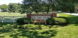
Williams Creek is a town in Washington Township, Marion County, Indiana, United States. It is located about 9 miles (14 km) north of downtown Indianapolis. The population was 430 at the 2020 census. It has existed as an "included town" since 1970, when it was incorporated into Indianapolis as part of Unigov. It is part of Indianapolis, but retains a functioning town government under IC 36-3-1-11.

<span class="mw-page-title-main">Crows Nest, Indiana</span> Town in Indiana, United States

Crows Nest is a town in Washington Township, Marion County, Indiana, United States, approximately 7 miles (11 km) north of downtown Indianapolis. The population was 67 at the 2020 census. It has existed as an "included town" since 1970, when it was incorporated into Indianapolis as part of Unigov. It is part of Indianapolis, but retains a functioning town government under IC 36-3-1-11.

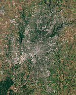
Indianapolis (balance) is a statistical entity defined by the United States Census Bureau to represent the portion of the city of Indianapolis, Indiana, that is not within the "included towns". As of the 2020 census the balance had a total population of 887,642.

References

  1. 1 2 "2022 U.S. Gazetteer Files: Indiana". United States Census Bureau. Retrieved April 14, 2023.
  2. 1 2 U.S. Geological Survey Geographic Names Information System: Wynnedale, Indiana
  3. 1 2 "P1. Race – Wynnedale town, Indiana: 2020 DEC Redistricting Data (PL 94-171)". U.S. Census Bureau. Retrieved April 14, 2023.
  4. 1 2 "U.S. Census website". United States Census Bureau . Retrieved January 31, 2008.
  5. Indiana Code 36-3-1
  6. "US Gazetteer files: 2010, 2000, and 1990". United States Census Bureau. February 12, 2011. Retrieved April 23, 2011.
  7. "Census of Population and Housing". Census.gov. Retrieved June 4, 2015.
  8. "U.S. Census website". United States Census Bureau . Retrieved December 11, 2012.