
Kinney County is a county located in the U.S. state of Texas. As of the 2020 census, its population was 3,129. Its county seat is Brackettville. The county was created in 1850 and later organized in 1874. It is named for Henry Lawrence Kinney, an early settler.
Laredo is a city in and the county seat of Webb County, Texas, United States, on the north bank of the Rio Grande in South Texas, across from Nuevo Laredo, Tamaulipas, Mexico. Founded in 1755, Laredo grew from a village to the capital of the short-lived Republic of the Rio Grande to the largest inland port on the Mexican border. Laredo's economy is primarily based on international trade with Mexico, and as a major hub for three areas of transportation: land, rail, and air cargo. The city is on the southern end of I-35, which connects manufacturers in northern Mexico through Interstate 35 as a major route for trade throughout the U.S. It has four international bridges and one railway bridge.
Zapata is a census-designated place (CDP) in and the county seat of Zapata County, Texas, United States. The population was 5,089 at the 2010 census. As an unincorporated community, Zapata has no municipal government but like all 254 Texas counties has four elected county commissioners chosen by single-member districts and a countywide elected administrative judge.

Santos Benavides was a Confederate colonel during the American Civil War. Benavides was the highest-ranking Tejano soldier in the Confederate military.
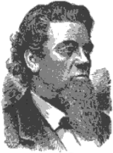
Richard King was a riverboat captain, Confederate, entrepreneur, and most notably, the founder of the King Ranch in South Texas, which at the time of his death in 1885 encompassed over 825,000 acres (3,340 km2).

The Republic of the Rio Grande was one of a series of independence movements in Mexico against the unitary government dominated by Antonio López de Santa Anna, including the Republic of Texas, and the second Republic of Yucatán. Insurgents fighting against the Centralist Republic of Mexico sought to establish the Republic of the Rio Grande as an independent nation in Northern Mexico. The rebellion lasted from 17 January to 6 November 1840.

The Cortina Troubles is the generic name for the First Cortina War, from 1859 to 1860, and the Second Cortina War, in 1861, in which paramilitary forces led by the Mexican rancher and local leader Juan Cortina, confronted elements of the United States Army, the Confederate States Army, the Texas Rangers, and the local militias of Brownsville, Texas, and Matamoros, Tamaulipas.

The Texas Mexican Railway was a short line railroad in the U.S. state of Texas operating between Corpus Christi and the Texas Mexican Railway International Bridge in Laredo, Texas. It is often referred to as the Tex-Mex, or TexMex Railway.
Santo Tomás was a coal-mining town near Laredo in west central Webb County, Texas, United States. The town was founded in 1801 by Antonio Gonzales and was named in honor of Saint Thomas. During the colonial era the land was used primarily for ranching. Pure quality cannel coal was found and extracted in 1873. In June 1882, the narrow-gauge Rio Grande and Pecos Railroad was built to transport the coal. By 1900, the town grew and had a population of approximately 1,000. By 1920, all the mines closed and the population of Santo Tomás decreased to 18. Today, Santo Tomás is a ghost town near the Colombia-Solidarity International Bridge.

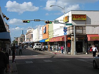
Downtown Laredo is the second main business district in Laredo, Texas. Downtown Laredo is the starting point for Interstate Highway 35 and State Highway 359. It is home to all of Laredo's high-rise buildings. Laredo's and Webb County's main government buildings are located in Downtown Laredo. Most of Webb County's National Register of Historic Places are in this area.
Chacon Creek is a small stream of water located in Webb County, Texas, US, which runs through Laredo. The creek is formed 6 miles from Webb and runs southwest for 20 miles until it connects to the Rio Grande. Chacon was dammed in 1951 in east Laredo to form Lake Casa Blanca, a 1,680 acres (6.8 km2) lake. The terrain surrounding the creek is mostly clay. The vegetation surrounding the creek is mostly made up of mesquite, cacti and grasses. Chacon Creek is cross by several highways in Laredo, including United States Route 59, Texas State Highway Loop 20, Texas State Highway Spur 400, Texas State Highway 359 and United States Route 83.
The Battle of Laredo was fought during the American Civil War. Laredo, Texas was a main route to export cotton to Mexico on behalf of the Confederate States. On March 18, 1864, Major Alfred F. Holt led a Union force from Brownsville, Texas, to destroy 5,000 bales of cotton stacked at the San Agustín Plaza. Colonel Santos Benavides commanded 42 Confederate soldiers and repelled three Union attacks at Zacate Creek. Colonel Santos Benavides secured passage of the 5,000 cotton bales into Mexico.
San Idelfonso Creek is a small stream of water located in Webb County, Texas which runs through Laredo, Texas. The creek is formed within east Laredo and runs southwest for 8 miles until connecting to the Rio Grande. San Ildefonso Creek was dammed in east Laredo to form San Ildefonso Creek Lake, the second largest Lake in Laredo. The terrain surrounding the creek is mostly clay and sandy loams. The vegetation surrounding the creek is mostly made up of mesquite, cacti, chaparral, hardwoods and grasses. San Idelfonso Creek crosses two major highways in Laredo, Texas among them are: Texas State Highway 359 and United States Route 83
Sombrerillito Creek is a small stream of water located in Webb County, Texas which runs through Laredo, Texas. The creek is formed 13 miles north of Laredo and runs southwest for 16 miles until connecting to the Rio Grande. Sombrerillito Creek was dammed in northwest Laredo to form Sombrerillito Creek Lake, the third largest lake in Laredo. The terrain surrounding the creek is mostly clay and sandy loams. The vegetation surrounding the creek is mostly made up of mesquite, cacti, chaparral, hardwoods and grasses. Sombrerillito Creek crosses one major highway in Laredo, Texas among them are: Farm to Market Road 1472.
Santa Isabel Creek is a small stream of water located in Webb County, Texas which runs through Laredo, Texas. The creek is formed 32 miles from Callaghan, Texas and runs southwest for 33 mi (53 km) until the creek connects to the Rio Grande. The terrain surrounding the creek is mostly clay. The vegetation surrounding the creek is mostly made up of mesquite, cacti, and grasses. Santa Isabel Creek crosses Three major highways in Laredo, Texas among them are: Farm to Market Road 1472, Texas State Highway 255, and United States Route 83.
San Ygnacio Creek is a small stream of water located in Webb County, Texas which runs through Laredo, Texas. The creek is formed 11 miles northwest of Laredo, Texas and runs southwest for 12 mi (19 km) until the creek connects to the Lake Casa Blanca. The terrain surrounding the creek is mostly clay. The vegetation surrounding the creek is mostly made up of mesquite, cacti, and grasses. San Ygnacio Creek does not cross any major highway.
The United States Border Patrol operates 71 traffic checkpoints, including 33 permanent traffic checkpoints, near the Mexico–United States border. The stated primary purpose of these inspection stations is to deter illegal immigration and smuggling activities. After the September 11 attacks in 2001, they took on the additional role of terrorism deterrence. These checkpoints are located between 25 and 75 miles of the Mexico–United States border along major U.S. highways; near the southern border of the contiguous United States. Their situation at interior locations allow them to deter illegal activities that may have bypassed official border crossings along the frontier. The checkpoints are divided among nine Border Patrol sectors. There are a number of these checkpoints near the northern border of the contiguous U.S. as well, within 100 miles (160 km) of the Canada–U.S. border.
The San Antonio–El Paso Road, also known as the Lower Emigrant Road or Military Road, was an economically important trade route between the Texas cities of San Antonio and El Paso between 1849 and 1882. Mail, freight, and passengers traveled by horse and wagon along this road across the Edwards Plateau and dangerous Trans-Pecos region of West Texas.

El Azteca is one of the oldest and most intact residential neighborhoods in Laredo, Texas, with buildings dating from the 1870s representing nearly every major architectural type and style that has appeared on the border since that time.

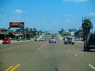
Interstate 69W (I-69W) is a relatively short north–south Interstate Highway running through South Texas in the United States. The freeway begins northeast of the middle of World Trade International Bridge in Laredo and ends at I-35. In the future, I-69W will head northeast for 180 miles (290 km) before terminating near Victoria as both I-69E and I-69W merge to form I-69. For its entire length, I-69W runs concurrently with US Highway 59 (US 59).


